 Explore Maharashtra
Maharashtra’s Forgotten Baravs: Mapping the Lost Wells
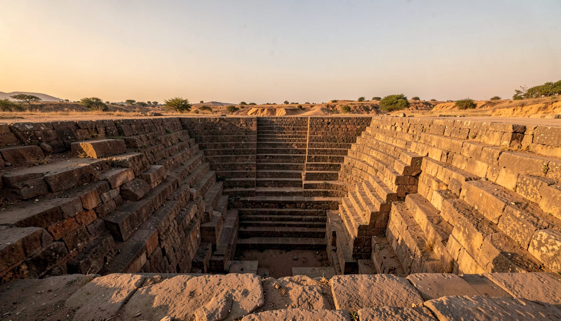
Across Maharashtra, old baravs are disappearing into farms, village lanes, urban expansion and scrubland. Some survive as recognisable masonry wells, while others remain only as broken steps, stone-lined depressions or names preserved in local memory. Unlike famous vavs and baolis promoted through tourism campaigns, many of these water structures have never been properly recorded.
Mapping them is more than a search for picturesque ruins. A barav reveals how communities collected water, organised settlements and adapted to long dry seasons. Through field photography, architectural sketches, satellite imagery and conversations with residents, forgotten wells can be placed back into the cultural and environmental history of the Deccan.
Reading Maharashtra’s Barav Landscape
The word barav is used in Maharashtra for a stepped or masonry-lined well, although local terminology varies. Baoli, bavdi, vav, kund and other regional names may describe structures with similar functions but different forms. Some wells descend through broad flights of steps; others use narrow stairways, retaining walls, galleries or small shrines. Their design often reflects the geology of the site as much as the wealth of the patron.
A barav was usually part of a wider water system. It might sit beside a temple, market route, settlement edge or agricultural field, receiving runoff from surrounding ground. A study of medieval water management helps place these structures within a larger history in which water access, public life and religious patronage were closely connected.
The Deccan plateau adds particular complexity to the search. Basalt bedrock, seasonal streams and monsoon-fed aquifers shape where wells could be built and how long they retained water. A structure that appears dry today may once have connected with a deeper groundwater level, while a silted entrance can conceal several metres of surviving masonry.
Why So Many Wells Became Invisible
Modern water infrastructure changed the role of the barav. Bore wells, piped supplies, farm dams and concrete tanks offered more convenient access, but they also reduced the need to maintain older public wells. Once a village no longer depended on a stepped descent for drinking water, vegetation and rubbish could quickly fill the lower levels.
Urban growth has created another layer of loss. Around Pune, Nashik, Aurangabad and smaller expanding towns, historic wells may be absorbed by roads, housing plots or industrial sites. A stone platform can be mistaken for ordinary rubble, particularly when later construction has removed decorative features. In agricultural districts, a barav may survive in a field but be excluded from official heritage records because it is considered too modest or too altered.
The hidden wells of Pune show why documentation must look beyond celebrated monuments. Even within a rapidly changing metropolitan region, overlooked wells can retain evidence of local craftsmanship, water engineering and community use. Their condition may be poor, but their placement often preserves a valuable record of how older neighbourhoods developed.
Building A Reliable Field Map
A useful inventory begins with coordinates, photographs and a consistent description of each site. Researchers can record the entrance orientation, number of visible steps, masonry type, water level, drainage channels, nearby shrines and signs of recent use. Drone imagery may reveal the relationship between a barav, field boundaries and seasonal watercourses, while satellite images can help compare the site across decades.
Written sources are only one part of the process. Old cadastral maps, gazetteers, temple records and revenue documents can provide clues, but spellings change and place names are frequently repeated. A village called Baravwadi or Baoli may indicate a water structure, yet the name alone cannot confirm its location. Local people may know the site by a family name, a former landlord’s name or a phrase that never appears on a map.
Fieldwork also requires careful judgement. A collapsed well should not be entered without checking for unstable edges, snakes, contaminated water and concealed openings. Photographers need permission when a structure lies on private farmland or within a temple compound. Recording a site respectfully matters as much as capturing its architecture, especially where residents still associate the well with family stories, rituals or difficult memories.
What Australia Can Learn From The Search
For an Australian audience, the barav story has clear relevance in a country shaped by drought, unreliable rainfall and contested water resources. People in regional Victoria or South Australia are familiar with dams, tanks, bores and dry creek beds, while residents of Sydney, Melbourne and Brisbane regularly hear about restrictions, catchment levels and the cost of keeping landscapes green. These experiences make an old Indian water structure easier to understand as infrastructure rather than an isolated ruin.
There are also practical parallels in heritage administration. An Australian council may maintain a heritage register, signage and a public planning record, yet small sites can still be missed when they lack a famous name or an active community group. In Maharashtra, a digital map with photographs and oral histories could perform a similar role, giving local authorities, schools and residents evidence before a road widening project or new subdivision removes the last traces.
The comparison should remain careful. Indigenous Australian knowledge systems have their own histories, custodianship frameworks and cultural protocols, and they should not be treated as interchangeable with South Asian stepwell traditions. The useful connection lies in recognising that water places carry social meaning as well as practical value. A heritage exhibition in Melbourne, a local-history programme in Bendigo or a university project in Perth could present baravs alongside broader conversations about water, climate and place without flattening those differences.
For Australian visitors, heritage tourism also works differently from a quick stop at a major monument. People may plan a road trip around regional galleries, National Trust properties, farmers’ markets or council-run walking trails. A carefully mapped barav route in Maharashtra could support local guides, photographers and small businesses, much as heritage trails around rural New South Wales or the Adelaide Hills connect architecture with food, landscape and community stories.
Turning Documentation Into Preservation
A map becomes valuable when it leads to action. Clear records can support applications for conservation funding, condition assessments and protective planning controls. They can also help communities decide which sites need urgent clearing, fencing, drainage repair or structural advice. Not every barav should be restored to an imagined original appearance; in some cases, stabilising surviving masonry and explaining the site may be the most responsible approach.
Interpretation should make the structure legible without inventing facts. A sign can explain how people descended to the water, who may have funded the construction and how the site related to nearby roads or temples, while clearly identifying uncertainty. Architectural drawings are especially useful where vegetation or damage makes the form difficult to read. Before-and-after photography can show seasonal changes and demonstrate why maintenance matters.
The abandoned wells documented in a Delhi field report offer a reminder that neglect is itself part of a monument’s story. Weeds, plastic, graffiti and stagnant water are not merely visual problems; they indicate a breakdown in ownership, access and public purpose. Maharashtra’s lesser-known baravs deserve records that capture both their original ingenuity and their present condition.
The most enduring work will involve residents as partners. A schoolchild may know a shortcut to a buried well, an elder may remember when its steps were cleared, and a farmer may understand where monsoon water once collected. Inviting communities to share undocumented locations can expand the map while returning knowledge to the people who live beside these sites. With patient research, original photography and responsible public access, lost wells can become visible again—not as romantic ruins, but as evidence of Maharashtra’s long relationship with water.
Get in Touch
Have information about a stepwell that is not yet on our map? We would be glad to document it and give you full credit. Whether it is a Barav, Kund, Vihir, or any other form of stepwell, every contribution helps preserve India's water heritage.
Call or message us with details about the location, and we will follow up.
#9372496819
Send a Message
What People Say
"The Maharashtra Stepwells campaign has brought attention to structures that were nearly forgotten. The architectural documentation and drone photography are invaluable resources for researchers and students alike."
"Collaborating with the Indian Stepwells team gave our architecture students hands-on exposure to traditional water-harvesting structures. The presentations were insightful and inspiring."
"I shared details of a stepwell near my village that was not on any map. The team visited, documented it beautifully, and credited me. It felt wonderful to contribute."