 Explore Maharashtra
Field Notes: Documenting a Rare Stepwell in Satara District
The road into rural Satara District narrows after the last busy market town, passing sugar-cane fields, basalt outcrops and clusters of houses shaded by neem and mango trees. Somewhere beyond the familiar routes lies a stepwell that rarely appears in architectural surveys. It is neither a grand tourist monument nor a clearly signposted historic attraction. Its value rests in its survival, its local memory and the clues preserved in stone.
Documenting such a structure requires more than taking attractive photographs. The work combines measured observation, oral history, architectural drawing, landscape reading and careful recording of present damage. A stepwell is a water-conservation system, a social space and a record of changing settlement patterns. Each of these aspects must be considered before the site can be understood.
For an Australian audience, the comparison is immediate. Water tanks, drought-conscious gardens and community concern for creeks are familiar parts of life in cities such as Melbourne, Brisbane and Adelaide. A stepwell extends that practical relationship with water into architecture, making conservation visible through every stair, landing and retaining wall.
Reaching the site beyond the mapped roads
The first field visit began with imperfect directions. A village name, a reference to an old shrine and a memory of “stone steps near the fields” were more useful than online mapping. In Maharashtra, undocumented water structures are often absent from official tourist material, while their locations remain known to farmers, temple caretakers or older residents.
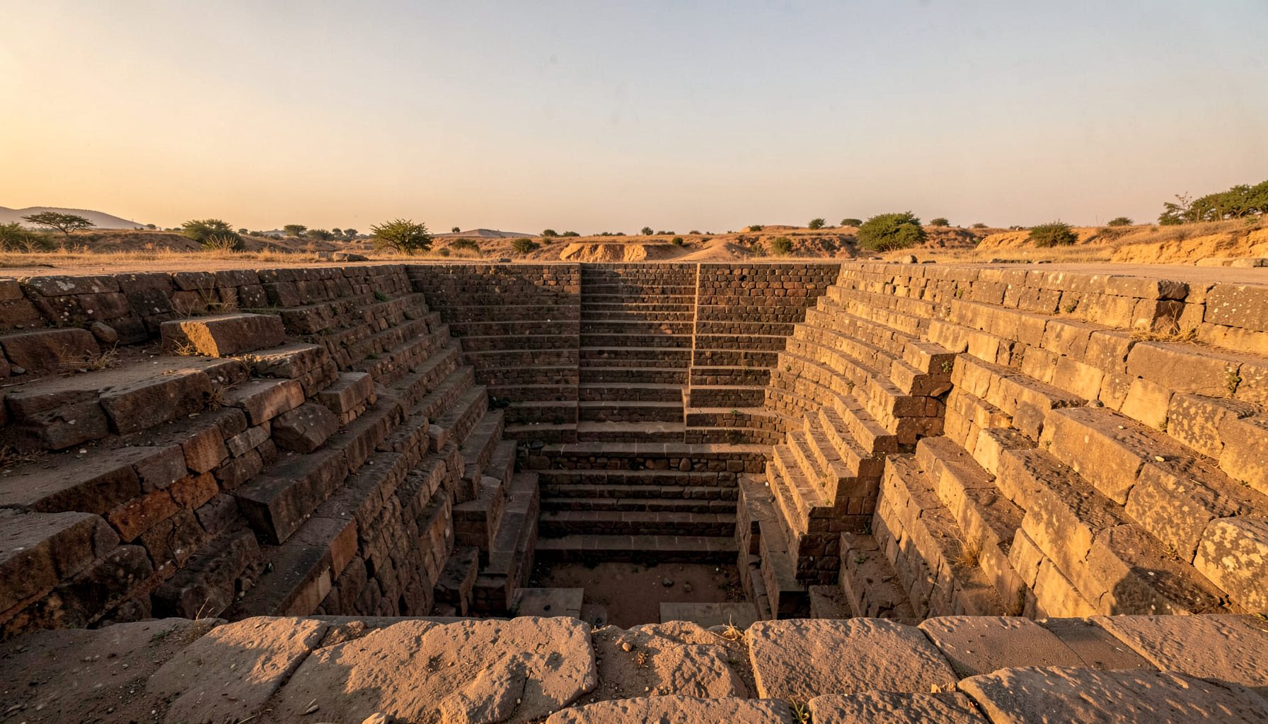
Approaching the site on foot revealed why it had escaped wider attention. Vegetation concealed the upper edge, and a later boundary wall interrupted the original setting. The stepwell sat below the level of the surrounding ground, partly protected from view by a stand of trees. From a distance, it looked like a dry depression. Only the dressed basalt blocks around the entrance disclosed its architectural purpose.
This kind of arrival is common in heritage fieldwork. A location can be technically recorded yet still remain difficult to interpret. Road access, seasonal crops, private land and changing village paths all affect how a researcher encounters a monument. The first notes therefore included access conditions, nearby buildings, drainage routes and signs of current use, rather than focusing only on the visible masonry.
Reading basalt, steps and shadow
The structure is modest in scale, but its construction is precise. Dark volcanic stone forms the retaining walls and stair flights, with joints that have softened under monsoon weather. The descent is arranged through a sequence of levels rather than a single uninterrupted staircase. Each landing would have offered a pause, a place to draw water and a shaded threshold between the village surface and the reservoir below.
The plan suggests an adaptation to local terrain. Unlike the ornate sandstone vavs of Gujarat, this Satara stepwell appears to rely on restrained geometry and durable material. Its architectural language belongs to a landscape of Deccan plateaux, seasonal rainfall and hard rock. Comparing it with stepwells of the Konkan Coast helps clarify how water structures change across Maharashtra, from basalt uplands to humid coastal settlements.
Photography was taken from fixed points before any close detail work began. Wide images recorded the relationship between the well and its surroundings, while vertical frames documented the stair alignment. Close photographs focused on tool marks, displaced blocks, plant roots, plaster traces and areas where water had eroded the lower courses. A scale bar and a north arrow were included whenever possible.
Notes for a reliable field record
A field notebook must distinguish between what is visible, what is reported and what remains uncertain. Local descriptions may preserve names and uses that do not appear in written sources, but memories can differ across generations. Recording those differences is more responsible than forcing every account into a single definitive story.
The following observations formed the core of the first survey:
- The structure is positioned below the surrounding agricultural ground, with a narrow approach from the settlement side.
- Basalt masonry survives along the principal stair and at least two lower retaining walls.
- Silt, leaf litter and invasive growth obscure the lowest section during the dry-season visit.
- No surviving inscription was confirmed, although several reused blocks deserve closer study.
- Residents associate the site with older water collection, but its date and original patron remain uncertain.
Measured sketches were prepared alongside photographs because dimensions communicate relationships that images can hide. The width of the stair, the spacing between landings and the height of retaining walls help compare the site with other bawdis, baolis, kunds and baravs. A drone image, taken only where permissions and conditions allowed, can reveal the buried outline of channels or the connection between the well and nearby fields.
The survey also follows the principle that an undocumented monument should not be exposed carelessly. Clearing vegetation or removing debris can damage evidence. Before any intervention, the site needs a condition assessment, a record of ownership and a conversation with people who live nearby.
Water, work and social memory
A stepwell was rarely only a technical device. Its stairs created a route to water, but they also shaped routine encounters. Women collecting water, travellers resting in shade, children passing through and villagers maintaining the structure all contributed to its social history. The article on community life around baolis offers a useful framework for reading these places as gathering spaces rather than isolated monuments.
In Satara District, oral accounts connected the well with agricultural work and seasonal scarcity. The reservoir may have supported household use at a time when settlement patterns, wells and irrigation arrangements differed from those of the present. Later borewells and piped supply reduced the stepwell’s practical role, while silt and neglect made descent difficult.
These changes are familiar to Australians who have watched dams, tanks and urban waterways move from essential infrastructure to heritage landscape. A rainwater tank in suburban Adelaide or a creek reserve in Melbourne can carry practical and emotional meaning even when it no longer performs its original function. The Satara stepwell similarly records a community’s long relationship with water, labour and adaptation.
Comparing methods across heritage work
Field documentation benefits from looking beyond one region. Reports on abandoned Delhi baolis show how neglect can be read through rubbish, invasive plants, damaged edges and altered access. Those signs are not merely visual distractions; they reveal how a monument’s relationship with its neighbourhood has changed.
A useful comparison also comes from volunteer-led heritage recording outside India. Local heritage initiatives in North Rhine-Westphalia demonstrate how community groups can preserve local memory through small archives, public events and shared documentation. The same principle applies to a rural stepwell: a few carefully recorded interviews may preserve information that formal inventories have missed.
Australian heritage practice provides another relevant reference point. In Victoria, the Heritage Act 2017 supports the protection of significant places, while Aboriginal heritage is addressed through the Aboriginal Heritage Act 2006 and its associated cultural heritage processes. Requirements differ across states and territories, yet the wider lesson is consistent: documentation, permissions and community consultation should precede physical work. A photographic survey is not automatically permission to clear, repair or publicise a vulnerable site.
From field notes to public record
The Satara survey will become more useful when the separate forms of evidence are brought together. Photographs show condition, sketches explain structure, drone imagery clarifies setting and interviews preserve names or memories. None is complete alone. Combined, they create a record that can support education, future conservation planning and responsible heritage interpretation.
The next stage is to compare the structure with other Maharashtra examples without flattening local differences. A database entry should include the site’s approximate location, access notes, construction material, plan, water relationship, present condition and sources of information. Sensitive details may need to remain restricted if publication could encourage vandalism, souvenir collecting or unregulated development.
Public presentation should be grounded in clarity rather than spectacle. The site is not simply a picturesque ruin. It is evidence of engineering knowledge, seasonal planning and community organisation. Australians accustomed to weekend farmers’ markets, local history rooms and council walking trails will recognise the value of making regional heritage accessible through small, trustworthy stories rather than only through major monuments.
A broader archive can also connect this stepwell with other forms of vernacular memory. Records such as Dead Ireland show how place-based research can gather fragments of local history into a resource that remains useful to families, researchers and communities. For Satara, the immediate priority is a durable record made with local consent, clear attribution and enough detail to guide future study without putting the structure at risk.
The finished field file will therefore contain more than a gallery of images. It will hold a measured drawing, a condition record, landscape photographs, interview summaries and notes on uncertainty. That careful incompleteness is valuable. It leaves room for new evidence, local corrections and future researchers who may return after the monsoon, when the same steps and stones reveal another aspect of the monument.
Get in Touch
Have information about a stepwell that is not yet on our map? We would be glad to document it and give you full credit. Whether it is a Barav, Kund, Vihir, or any other form of stepwell, every contribution helps preserve India's water heritage.
Call or message us with details about the location, and we will follow up.
#9372496819
Send a Message
What People Say
"The Maharashtra Stepwells campaign has brought attention to structures that were nearly forgotten. The architectural documentation and drone photography are invaluable resources for researchers and students alike."
"Collaborating with the Indian Stepwells team gave our architecture students hands-on exposure to traditional water-harvesting structures. The presentations were insightful and inspiring."
"I shared details of a stepwell near my village that was not on any map. The team visited, documented it beautifully, and credited me. It felt wonderful to contribute."