 Explore Maharashtra
Water, Gold and the Stepwells of Kolar
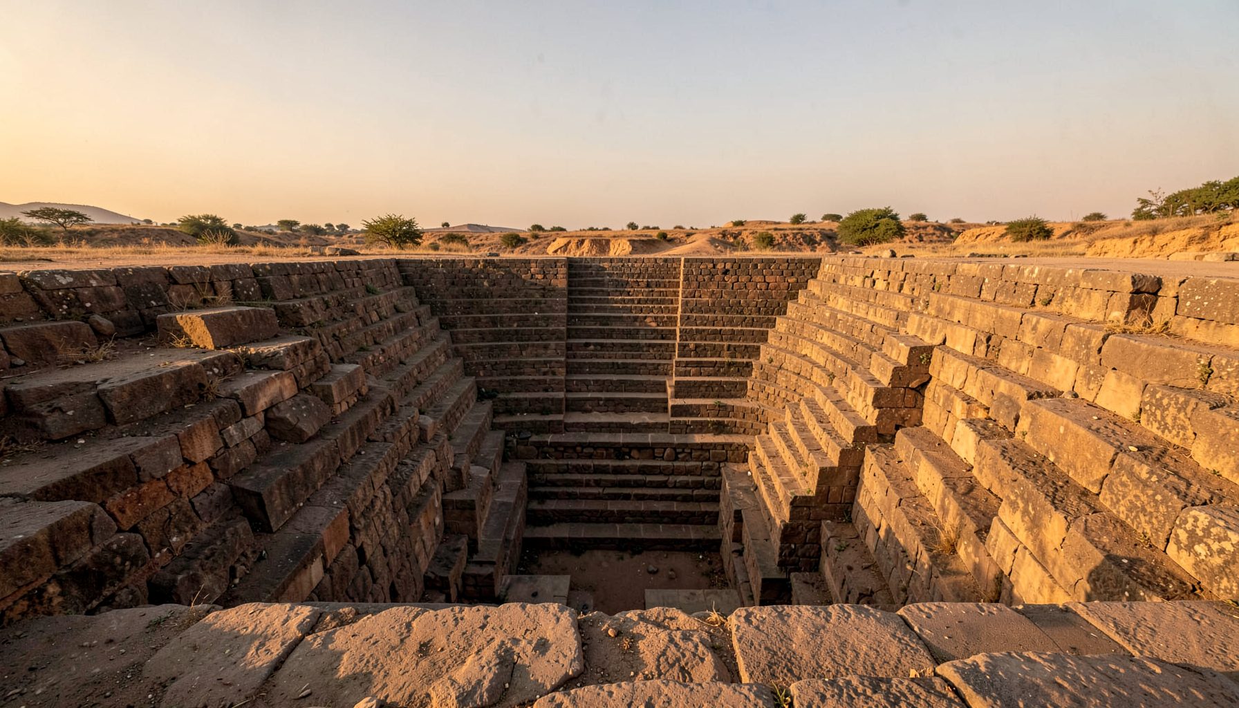
The stepwells of the Kolar Gold Fields—a mining town's water source—reveal a history beneath the better-known story of gold. Around Kolar in Karnataka, extraction created an industrial settlement of offices, workers' quarters, hospitals, clubs and transport lines. Such a town needed constant water. Before the shafts went deep, communities depended on wells, tanks and access points to groundwater. These structures record how people managed a finite resource while building an industrial town.
Kolar lies on the Deccan Plateau, where rainfall is sharply seasonal. Its historic water system combined household wells, large village tanks, temple reservoirs and stepped wells for storage and recharge. Terms overlap: a kund can mean a tank or reservoir, while baoli, bavi and bawdi can describe a stepped or enclosed well, so careful description matters more than a single label.
Gold mining reorganised that inherited system. Commercial extraction began in the early twentieth century; the field later became one of the world's deepest gold mines, with workings approaching three kilometres below the surface. Under Mysore administration, settlement expanded, demand surged, and pumping water from shafts changed subsurface drainage. Wells serving a compact town were absorbed into a crowded industrial landscape. Some were capped, built over or buried beneath spoil; others continued in use as water levels and community relationships changed.
The surviving stepwells are infrastructure and evidence. Their positions can reveal older village edges, worker routes and links between sacred space, public gathering and labour. They complicate a story in which human history begins with the first shaft. At Kolar, pre-mining custom, colonial-era expansion, mine engineering and post-mining memory occupy the same ground.
Gold, water and the shape of a mining town
A stepwell creates a relationship between ground, water and people. Descending steps make the water table visible, while landings and corridors support conversation, ritual and routine tasks. In a hot mining town, a dependable well could organise a neighbourhood more effectively than a distant river. It supplied drinking water, gardens, animals and cleaning, and created a public place where news travelled.
At KGF, those functions belong to a layered landscape. Some wells may predate the mining boom; others may have served worker settlements or replaced older sources as groundwater conditions changed. They should not be confused with the mine's pumped industrial supply. Their value lies in the civic water system around which town and neighbourhood life developed.
Photography can show this layered story without turning it into a picturesque legend. The attention given to the Rosses Point doorway in Ireland, where twelve carved apostles occupy a church entrance, offers a parallel: recording handiwork around a major historical place can reveal the people who cared for it. The same principle applies to worn steps, repaired plaster, pipes and buckets at Kolar's wells.
Reading a fragmentary water landscape
The surviving picture is fragmentary. Some wells are masonry monuments; others survive as depressions, cisterns, altered platforms or entries in old plans. Kolar's historic kunds and larger tanks belong to the same water-care system even when they are not stepwells in the strict sense. Comparing them shows how a settlement could combine a deep well for reliable supply with a broad tank for storage, animals and shared use.
Documentation must separate observation from inference. A structure's condition may conceal an older phase, and the date of a nearby mine office does not date the well beside it. Record local spellings, including Kannada and English variants, because digital indexing flattens distinct places into one label. Maps, archaeological reports and family accounts can then test each identification and reveal access rules, labour arrangements and ownership that masonry conceals.
Digital searching is only a starting point. A broad keyword search may surface unexpected adult results beside genuine heritage material, showing how little relevance ranking can guarantee. Field visits, archival maps and conversations with residents remain more reliable than a search snippet. A location should enter the archive only after its form and setting have been checked on the ground.
Monsoon fieldwork and changing visibility
The monsoon transforms a stepwell. Dry-season photography shows masonry, tool marks, niches and the relation between the well and surrounding lanes; rains reveal how water collects and moves. Reflections can clarify submerged geometry, but also conceal worn surfaces. Surplus water may close access, soften steps and turn an archaeological image into a record of a working neighbourhood.
Photographers should work with local conditions rather than treat the monsoon as picturesque. The practical advice in monsoon photography guidance is relevant: protect equipment, prepare for sudden rain, keep footing on wet stone and ask before entering restricted or working areas. Drone imagery can add a plan view, but authorisation, safety and community privacy come first.
Recording should continue after the clouds clear. A water-level note, an access sketch, a photograph of later repairs and a note about present use can tell more about continuity than one dramatic image. For Kolar, compare mining plans with pre- and post-mine photographs to work out whether a structure was neglected, repurposed or still serving a community after closure.
Why the story resonates with Australian visitors
For Australian visitors, Kolar's mining history sits beside familiar stories from Broken Hill and Kalgoorlie. Both developed around hard rock, imported labour and extreme inland climates, although their histories and responsibilities to Traditional Owners are distinct. A sound comparison names Paakantyi Country in Broken Hill and Wongatha Noongar Country in Kalgoorlie; it never turns Aboriginal custodianship into a decorative parallel.
Vocabulary can bridge the distance. Australians say bore for a groundwater shaft and tank for a stored reservoir, so a guide might explain that a kund functions as a community tank and a baoli as a stepped well. Place names should be spoken as locals use them, with Kannada forms where possible. In Kolar, KGF is heard as the letters K-G-F, while the district keeps its Kannada name.
Australian heritage audiences often encounter such material through memberships, print sales, guided walks, workshops and small exhibitions rather than mass tourism. A model exists in the effort to document Maharashtra’s forgotten baravs, where mapping lost wells can recover village knowledge. For KGF, the equivalent focus would connect mining records to older neighbourhood histories rather than isolate every well as a monument.
- Broken Hill and Kalgoorlie offer Australian points of comparison for remote mining settlements, heat, dust and reliance on groundwater.
- Darwin's wet season provides a climate reference for the monsoon, although its coastal humidity and rainfall pattern differ from the Deccan.
- The familiar terms bore and tank can bridge technical descriptions, while kund, baoli and bawdi remain essential local names.
- Camera clubs and local museums can supply photographers, oral historians and audiences, echoing the partnership model used by independent heritage publishers.
Building a living archive for Kolar
Preservation begins with identification, but should not stop at putting a well on a map. A structure in active use needs maintenance and clean water; a capped well needs archaeological care; one inside a compound needs negotiated access. These differences matter as much as a handsome elevation or drone image.
Local knowledge can keep the project grounded. Residents may know a kund by an occupational name, remember where people queued for water or recognise pipes absent from drawings. Such memories should be recorded with consent, checked against evidence and credited to their holders. Shared findings can restore neglected structures to the town's story rather than present researchers as its sole interpreters.
- Map every known kund, baoli, bavi and bawdi, recording location, condition, ownership, water use and exact local name.
- Compare old maps, land records, mine surveys and family photographs before assigning a construction date.
- Photograph with scale and context, sketch the section, record water levels, and note repairs or utility changes.
- Share accessible copies with communities and researchers, preserve oral histories, and seek conservation advice before intervention.
The archive could combine survey data with photographs, sketches, historic maps and audio. Each entry can separate the structure's age, the period of a repair and the date of a photograph. That transparent chronology would make it useful to conservation bodies, local government, museums and residents, giving the Kolar Gold Fields a water history as substantial as its mining history.
Get in Touch
Have information about a stepwell that is not yet on our map? We would be glad to document it and give you full credit. Whether it is a Barav, Kund, Vihir, or any other form of stepwell, every contribution helps preserve India's water heritage.
Call or message us with details about the location, and we will follow up.
#9372496819
Send a Message
What People Say
"The Maharashtra Stepwells campaign has brought attention to structures that were nearly forgotten. The architectural documentation and drone photography are invaluable resources for researchers and students alike."
"Collaborating with the Indian Stepwells team gave our architecture students hands-on exposure to traditional water-harvesting structures. The presentations were insightful and inspiring."
"I shared details of a stepwell near my village that was not on any map. The team visited, documented it beautifully, and credited me. It felt wonderful to contribute."