 Explore Maharashtra
The Stepwell That Doubles as a Bus Stop in Rural Maharashtra
In rural Maharashtra, a stepwell can be more than a relic beside an old road. It may remain part of village life: a shaded place to wait, meet, rest, load supplies or catch the bus. A stone platform, parapet or entrance pavilion can quietly become transport infrastructure, even when the original water system is no longer functioning.
This unusual afterlife reveals why bawdis, baolis, vavs, kunds and baravs need to be understood as living heritage. Their value is architectural, environmental and social at once. A structure used every day may have a better chance of survival than one fenced off and forgotten, provided practical use does not erase the details that make its history legible.
A Water Structure Along A Working Road
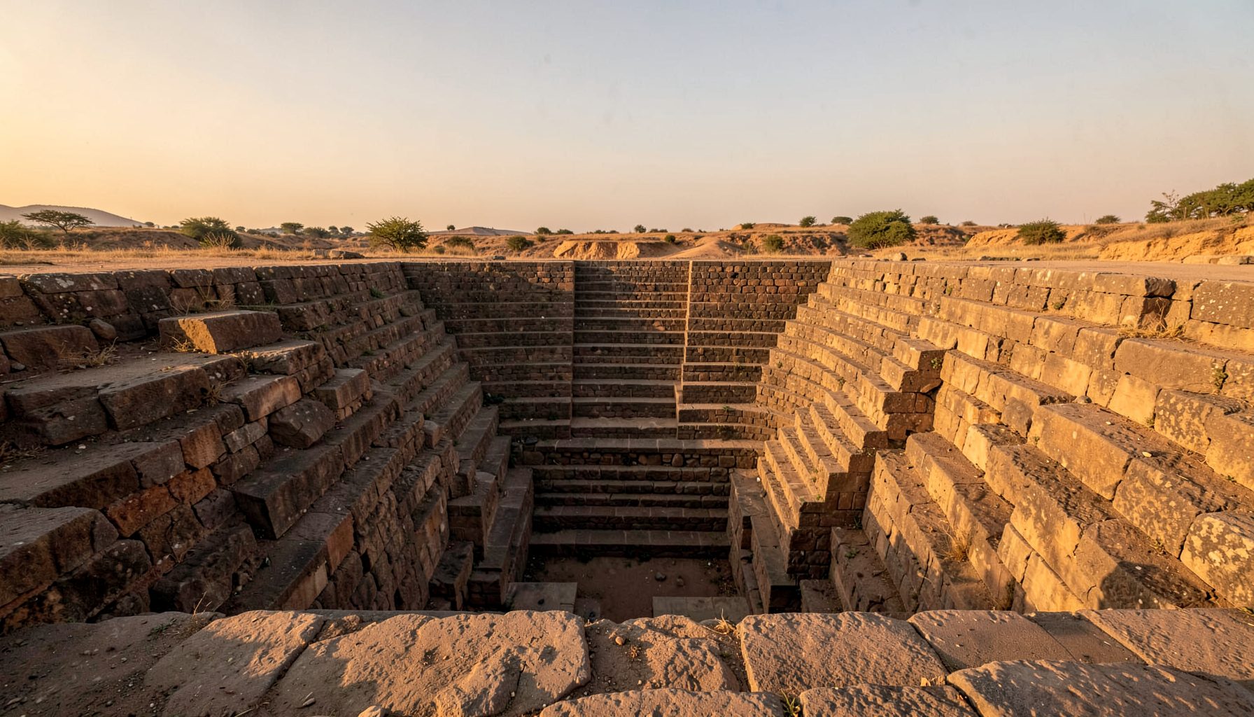
The stepwell in this story belongs to the broad family of baravs found across Maharashtra. Built to collect groundwater and provide access through descending flights of stairs, these wells were often positioned near settlements, temples, market routes and agricultural paths. Their design offered shade, cooler air and a dependable water source through the dry season.
Today, a rural bus route changes the rhythm of the place. Passengers arrive before sunrise, schoolchildren gather with bags, and older residents wait beneath masonry that was designed for a very different kind of movement. The bus may stop beside the entrance rather than at a formal shelter. A low wall becomes a seat, while the deep stairway remains partly hidden behind weeds, silt or a locked grille.
For a traveller used to a marked stop outside a regional town in Victoria or New South Wales, the arrangement can seem improvised. In Maharashtra, however, roadside life often grows around whatever shade, elevation or shelter is already available. The result is an informal interchange between historic architecture and contemporary mobility.
When Everyday Use Protects Heritage
Regular use can help preserve a stepwell because people notice damage quickly. A broken coping stone, unsafe edge or blocked approach affects commuters as well as heritage visitors. Local residents may sweep the platform, repair a small section of paving or place a simple shade cloth nearby. These modest acts can keep a monument visible when formal conservation funding is limited.
Yet usefulness can also conceal vulnerability. Cement ramps may cover carved stone, advertisement boards can obscure inscriptions, and rubbish may collect in the dry basin. Motorcycles, buses and informal stalls introduce vibration, smoke and pressure around fragile masonry. If the water chamber is still connected to the local aquifer, pollutants from the road can also affect groundwater quality.
The adaptive reuse of historic places is not automatically harmful. A thoughtful comparison can be found in this account of a stepwell school, where a former water structure gained a new civic purpose. The key issue is whether a new use respects the original form and keeps its story available to the public.
Reading The Bus Stop As A Cultural Landscape
A stepwell bus stop should be read as a whole landscape rather than an isolated object. The approach road, nearby shrine, trees, farm tracks, tea stall and seasonal drainage may all explain why the well was built where it stands. Aerial images can reveal alignments that are difficult to see from ground level, while sketches record levels, stair geometry and surviving ornament.
This wider view matters in Maharashtra, where many water structures have lost their original names or are known by several local names. A village might call the same place a barav, a well, a kund or simply the old water place. Oral accounts can identify former water levels, festivals, cleaning practices and the routes used by women collecting water.
Documentation also needs an ethical sense of place. Heritage recording should not flatten local experience into a picturesque photograph, nor should it treat every ruin as an attractive backdrop. The discipline required to preserve difficult and layered memories can be seen in regional memory work, where local history is connected to wider events through careful research and public responsibility.
What Australian Visitors May Notice
For Australians, the most immediate comparison may be a roadside shelter in the bush: a functional place that acquires meaning through repetition. A bus stop outside Bendigo, Toowoomba or Wagga Wagga may be modest, practical and maintained by several agencies, with its significance understood through everyday use rather than grand architecture. The Maharashtra example adds depth, stonework and centuries of water engineering to that familiar civic role.
There is also a useful connection with Australian water history. Tank stands, stock routes, irrigation channels and outback wells show how infrastructure can shape settlement patterns. In a dry region of Maharashtra, the stepwell carries a similar lesson: water access was planned socially, not treated as a private convenience. Its stairs made groundwater reachable across changing seasons and for different users.
Australian heritage audiences are also accustomed to the tension between access and protection. A local council may balance a heritage register, disability access, school excursions, tourism signage and public safety at the same time. The same conversation applies here. A rural stop needs shade, seating and safe movement, but conservation decisions should avoid disguising the original structure as a generic bus shelter.
Recording A Place Before It Changes
A useful survey begins with basic evidence. Record the structure from every side, measure the visible plan, photograph masonry joints and note the condition of stairs, retaining walls, coping stones and drainage. Record bus movements, pedestrian paths and current uses without disrupting them. A simple site diary can be as valuable as a dramatic drone image.
Local names and memories should be captured alongside architectural data. Who cleans the site? When did the bus begin stopping there? Was the well once used for cattle, irrigation, religious gatherings or domestic water? Has the road shifted? Answers may come from shopkeepers, drivers, farmers, students and elders whose knowledge is absent from official records.
Digital publication can then connect a small rural structure with a wider audience. The Indian Stepwells archive brings together field photography, architectural sketches and research that help readers recognise patterns across regions. For Maharashtra, mapping work on forgotten baravs shows why even partial evidence is important: a location, image or local term may become the starting point for future conservation.
Practical Principles For Shared Use
The best approach is usually low-impact and reversible. A bus stop can remain a bus stop without adding heavy structures to historic masonry. Clear boundaries, discreet seating and a small sign explaining the well’s history may provide more benefit than a large redevelopment project. Safety improvements should be designed around the monument, not imposed over it.
Any proposal should involve the people who rely on the site. Transport officials, village councils, school staff, heritage specialists and residents may identify different priorities. A local conversation can prevent a well-intentioned upgrade from blocking access, damaging a water channel or removing a place that commuters already trust.
- Map the stepwell, road edge, drainage and pedestrian routes before altering the site.
- Use removable shade, seating and signage wherever practical.
- Keep original stonework visible, ventilated and free from unnecessary paint or cement.
- Consult bus drivers, residents, schools and local custodians about daily needs.
- Test water quality before presenting the structure as an active water source.
- Create a maintenance record with photographs, dates and responsible contacts.
A small interpretive panel could explain the terms barav, bawdi, baoli, vav and kund, while also naming the local word used by the village. It might show a drawing of the original water system and note how the bus stop emerged. For Australian visitors, this kind of interpretation would feel familiar: like a roadside heritage marker, but connected to a place still woven into daily travel.
A Future Built Around Care
The stepwell’s continued use offers a more nuanced model than either abandonment or museum-style isolation. Its bus-stop function keeps it visible, but visibility alone is not conservation. The structure needs regular inspection, careful drainage, controlled repairs and a record of changes. If a new shelter is required, it should stand clear of the historic fabric and use materials that do not compete with the stone.
There is also potential for local education and responsible tourism. A nearby school could document seasonal water conditions, while photographers and researchers could share images that support a village archive. Visitors should arrive with respect for commuters and residents, remembering that this is a working public place rather than a staged attraction.
A rural Maharashtra stepwell that shelters bus passengers tells a larger story about adaptation. Water architecture survives here because it remains useful, but its deeper meaning comes from the connection between design, climate, memory and community. Preserving that connection allows an ordinary wait for the next bus to reveal an extraordinary history.
Get in Touch
Have information about a stepwell that is not yet on our map? We would be glad to document it and give you full credit. Whether it is a Barav, Kund, Vihir, or any other form of stepwell, every contribution helps preserve India's water heritage.
Call or message us with details about the location, and we will follow up.
#9372496819
Send a Message
What People Say
"The Maharashtra Stepwells campaign has brought attention to structures that were nearly forgotten. The architectural documentation and drone photography are invaluable resources for researchers and students alike."
"Collaborating with the Indian Stepwells team gave our architecture students hands-on exposure to traditional water-harvesting structures. The presentations were insightful and inspiring."
"I shared details of a stepwell near my village that was not on any map. The team visited, documented it beautifully, and credited me. It felt wonderful to contribute."