 Explore Maharashtra
Drone Imagery Reveals the Scale of Chand Baori
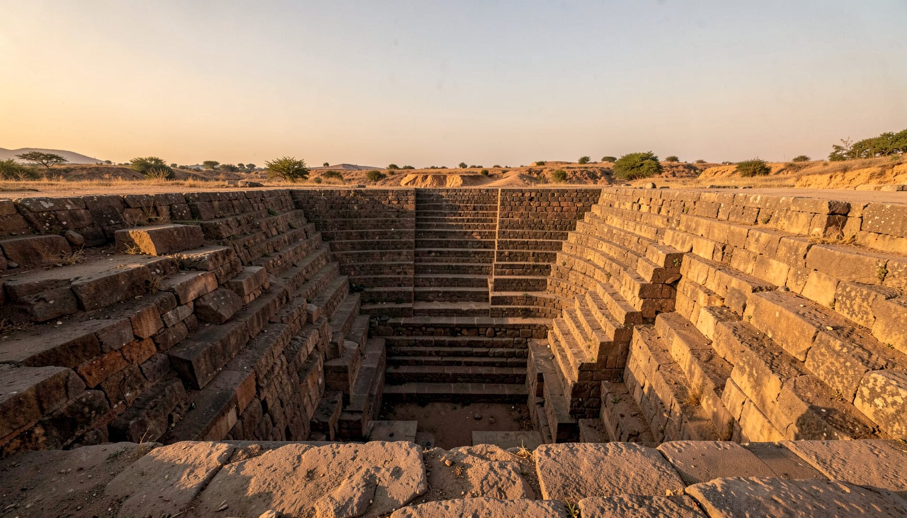
Perched in the quiet village of Abhaneri in Rajasthan, Chand Baori has long drawn visitors who descend its 13 stories of sandstone steps to the green-black water far below. Constructed in the eighth or ninth century, the inverted-pyramid well plunges roughly 30 metres into the earth and holds 3,500 narrow steps arranged in a precise criss-cross pattern. For generations, travellers, scholars, and pilgrims have written about its depth, but it took the slow drift of a drone above the site to give the world a real sense of its scale.
The aerial surveys completed in recent seasons have reshaped how heritage researchers understand the structure. What once appeared in photographs as a deep rectangular pool now reads, from above, as a vast geometric composition that extends well beyond the visible well shaft. For Australian readers familiar with the wide, dry expanses of the outback and the red-soil landscapes near Broken Hill, the bird's-eye view of Chand Baori offers a kindred sense of open terrain punctuated by an extraordinary human-made monument.
Origins and architectural DNA
Chand Baori sits within a wider tradition of subcontinental water architecture that spans arid Gujarat, the Deccan plateau, and the dry interior of Rajasthan. The well is traditionally attributed to King Chanda of the Nikumbha dynasty, with the surrounding Harshat Mata temple built by his descendant Raja Chandradev. Built during a period when monsoon reliability was declining and groundwater management was a matter of survival, the structure served not only as a water source but as a gathering point for surrounding villages. Its proportions reflect a careful balance between ritual purity, hydraulic efficiency, and craftsmanship.
The geometry of the well is its most studied feature. Three sides plunge down as stepped landings, while the fourth wall rises vertically and contains the dark galleries of the royal palace. From ground level the eye cannot trace every landing or flight of steps, which is why old travellers often described Chand Baori as an underground maze. Heritage researchers at institutions such as the University of Melbourne's architecture faculty have long pointed to the well in their studies of pre-modern hydraulic engineering, comparing its design logic to rainwater harvesting systems documented in the rock-cut cisterns near Adelaide's dry interior regions.
The materials are mostly locally quarried sandstone, dressed and laid without mortar at the load-bearing joints. Lime plaster, where it survives, traces the channels that once directed overflow toward nearby gardens and agricultural plots. Restorers who visited the site alongside the drone team noted surface erosion on the western face that had previously been hidden from ground-level surveyors.
How the drone survey was conducted
The aerial documentation at Chand Baori used a combination of high-resolution still photography and structured photogrammetry. Drones flew pre-programmed grids above the site during the cooler morning hours, when shadows raked across the steps and revealed the geometry more clearly than midday sun would. Surveyors flew at multiple altitudes, from a tight 15-metre sweep across the well mouth to a broader 80-metre pass that captured the temple complex and surrounding village rooftops. Each flight captured hundreds of overlapping frames that were later stitched into measurable three-dimensional models.
Such methodology is familiar to Australian heritage practitioners working across sites like the rust-red gorges of Karijini National Park or the timber bridges of Tasmania's east coast, where similar photogrammetric surveys support conservation reports. The Civil Aviation Safety Authority regulates recreational and commercial drone use in Australia, and Indian operators navigate their own DGCA framework, but the survey principles remain closely aligned across the two countries. GPS-tagged ground control points were placed around the well's perimeter, allowing the final models to be accurate within a few centimetres.
The drone team worked in close coordination with the Archaeological Survey of India, local village elders, and visiting researchers. Flights were paused during festival days when crowds gathered near the well, and safety zones were established to keep the aircraft away from the temple's carved pillars. The resulting archive now sits with the documentation team and is being prepared for open academic release later in the year.
Geometry, symmetry, and scale from above
From the air, Chand Baori resolves into a series of nested rectangles that taper toward a small square at the base. The criss-cross pattern of the flights creates a woven lattice that is hard to appreciate from the bottom of the well. The drone imagery makes it possible to count landings, identify concealed chambers, and measure the true footprint of the monument for the first time with any precision. Researchers have identified subtle asymmetries that suggest the well was built in distinct phases, with later additions extending the eastern landing and reinforcing the north wall.
The aerial study also revealed features that ground surveys had missed entirely. A second, smaller stepwell lies just to the south of Chand Baori, partially obscured by collapsed masonry and modern construction. A series of low stone walls, once channels for channelled monsoon runoff, fan out across the surrounding plain and link the well to outlying fields. Patterns documented here rhyme with those explored in symmetry in Gujarat's vavs, where similar criss-cross staircases and proportional systems have survived in towns such as Adalaj and Champaner.
The aerial perspective also captures the relationship between the well and its temple. From above, the Harshat Mata temple reads as a courtyard complex whose axis aligns with the well's central staircase, suggesting that ritual movement between the two was carefully choreographed. Drones positioned over the temple roof documented carved ceiling panels that are barely visible from ground level and are now being cross-referenced with sculptural fragments held in regional museums.
Chand Baori in a wider heritage context
India holds thousands of historic stepwells, but few combine the depth, age, and architectural ambition of Chand Baori. Bawdis in the Deccan, kunds in the Thar, and vavs across Gujarat each carry regional variants of the form, but Chand Baori stands as one of the deepest and most intricately decorated. Its presence in international film and travel media has made it a touchstone for public understanding of Indian water heritage, and the new drone imagery will sharpen that recognition.
For Australians planning heritage-themed travel, the well offers a counterpoint to familiar sites such as the industrial-era pumping stations of Melbourne's Maribyrnong or the stone cisterns of Sydney's colonial gardens. Photography exhibitions at venues like Sydney's Australian Centre for Photography have begun to include Indian water architecture, and several galleries in Brisbane and Perth have hosted travel-photography shows that touched on Rajasthan's monuments. Travellers seeking out Chand Baori often combine it with visits to Jaipur, Pushkar, and the Abhaneri temple complex itself.
Researchers exploring lesser-documented wells in Maharashtra will find a useful parallel study in The Hidden Stepwells of Pune: A Photographic Journey, which applies a similar blend of ground photography and aerial survey to a different regional tradition. Together, these projects are building a national picture of stepwell architecture that exceeds anything previously attempted, with drone surveys promising to accelerate the work in years to come.
Conservation lessons from the aerial record
The drone imagery carries practical lessons for conservation planning. By mapping surface erosion with precision, the survey team can target restoration work on the most vulnerable landings rather than treating the well as a uniform whole. The high-resolution record also serves as a baseline against which future change can be measured, whether from natural weathering, tourist foot traffic, or local development pressures.
Indian heritage authorities have begun integrating drone surveys into broader conservation strategies, and several state governments now require aerial documentation as part of any major restoration proposal. Community participation remains vital, and villagers in Abhaneri have contributed oral histories that help interpret features visible only from above. Funding models are also evolving, with international heritage grants, philanthropic trusts, and cultural-tourism revenue each playing a role.
Looking ahead, the team behind the Chand Baori survey is training local guides in basic drone operation so that monitoring can continue between major fieldwork seasons. Similar pilots in Tamil Nadu, Karnataka, and Gujarat are already underway. As the archive grows, scholars in cities as far from Abhaneri as Sydney, Canberra, and Perth will be able to study Chand Baori through interactive three-dimensional models, contributing their own analyses and helping keep the monument's story alive for new generations.
Recommendations for visitors and researchers
- Visit Chand Baori in the cooler months between October and February, when morning light rakes across the steps and the well is most photogenic from the surrounding rooftops.
- Carry a wide-angle lens and a small drone if your local regulations permit it, and always check with site authorities before flying near heritage structures.
- Pair a visit to Chand Baori with the Harshat Mata temple to understand the ritual geography that the drone imagery has begun to reveal.
- Read the related field studies on Gujarat's vavs and Pune's hidden stepwells before your trip to ground your photography in architectural context.
- Engage respectfully with village guides, who often hold detailed knowledge of the well's lesser-known chambers and seasonal rituals.
- Support organisations working on stepwell documentation through donations, image licensing, or by sharing field photographs with regional archives.
- Consider scheduling time in Jaipur or Delhi afterward to compare Chand Baori with the larger stepwell traditions documented along the trade routes of Rajasthan.
Get in Touch
Have information about a stepwell that is not yet on our map? We would be glad to document it and give you full credit. Whether it is a Barav, Kund, Vihir, or any other form of stepwell, every contribution helps preserve India's water heritage.
Call or message us with details about the location, and we will follow up.
#9372496819
Send a Message
What People Say
"The Maharashtra Stepwells campaign has brought attention to structures that were nearly forgotten. The architectural documentation and drone photography are invaluable resources for researchers and students alike."
"Collaborating with the Indian Stepwells team gave our architecture students hands-on exposure to traditional water-harvesting structures. The presentations were insightful and inspiring."
"I shared details of a stepwell near my village that was not on any map. The team visited, documented it beautifully, and credited me. It felt wonderful to contribute."