 Explore Maharashtra
Fatehpur Sikri Baoli: Water for a palace
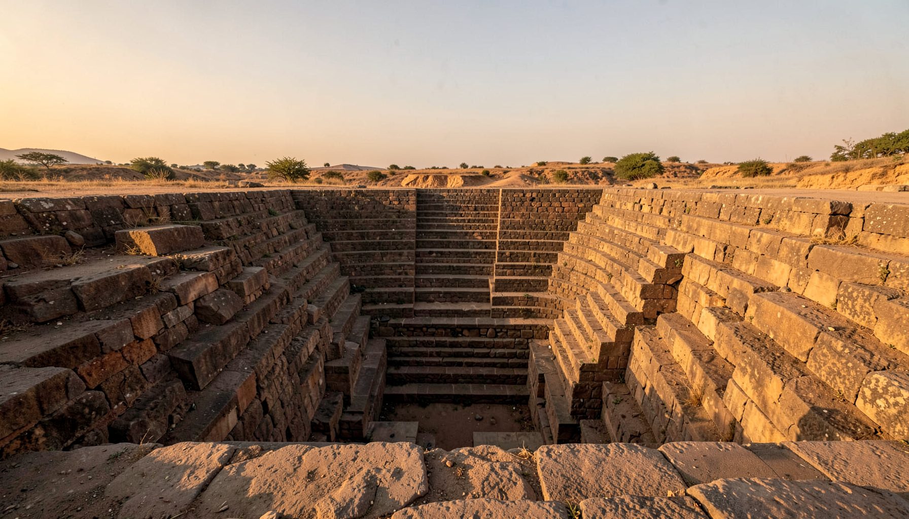
At first glance, the Fatehpur Sikri Baoli is a descending composition of sandstone steps, carved niches and shadowed landings. Its visual drama often leads visitors to see it as a palace monument rather than a working piece of infrastructure. Yet the structure was designed around water: to collect seasonal rain, hold it below ground and make a fluctuating resource available through architecture. In the imperial city established by Akbar in 1571, it formed part of a larger system serving the palace and nearby community.
A stepwell is a deep well reached by stairs, and in semi-arid north India it could become a civic reservoir during the monsoon and a dependable source through the dry months. The Fatehpur Sikri Baoli was not an isolated ornament; it sat within a landscape of wells, tanks, channels, gardens and service spaces. Reading its ramps, plinths and drainage points reveals how Mughal planners connected water, movement, authority and daily life, while also prompting questions about who could use the supply and who maintained it.
A stepwell in the Mughal city
Fatehpur Sikri was conceived as a planned capital on a high plateau near Agra, with sandstone buildings arranged around courts, gardens and waterworks. The baoli’s depth kept the surrounding ground cool, while its stair flights gave people and animals a practical route to the water. Its monumental scale also made water collection visible, turning a necessary daily task into a shared civic ritual.
That wider relationship between architecture and survival is the subject of Indian Stepwells’ Maharashtra campaign, which surveys historic water structures and their settings. A campaign can reveal how a baoli functioned alongside homes, fields and religious spaces, rather than treating it as an isolated monument. At Fatehpur Sikri, that contextual view places the stepwell within the working capital, not outside it.
Water for the palace complex
The palace needed water for kitchens, baths, gardens, workshops, animals and the daily movement of attendants and residents. A dependable supply was therefore a form of political administration as well as household convenience. At Fatehpur Sikri, the baoli helped receive seasonal runoff and store it below the surface; associated channels, wells and tanks formed a network for moving and managing that water.
Surviving geometry and historical references to the city’s waterworks support understanding the Fatehpur Sikri Baoli as part of the supply that sustained the palace complex. Its exact operating sequence is not fully recoverable, so historians should distinguish between direct evidence and reasonable reconstruction. Even with that caution, the central point is clear: this deep water source made the occupied palace possible during dry weather and linked monumental design to practical survival.
Architecture of a shared water source
The baoli’s design works through levels. Broad flights descend toward the water, while side platforms, columns, projecting brackets and carved niches organise bodies, shade and movement. As the reservoir rose, people approached it by different stair sections; as it fell, the changing waterline became a visible measure of the season. Stone, shadow and moving water combined to moderate heat and make the reservoir feel like an inhabited room.
Decorative detail also had a practical role. Repeated motifs, niches and enclosed corners provide places to sit, wait and exchange news, while the descending geometry directs the eye and the body downward. Architectural sketches and close photography can record these relationships more clearly than a single frontal image. Drone views, used responsibly and within local permissions, can also show how the baoli sits among the palace’s courts and roofscape.
A changed water landscape
Time has transformed the relationship between monument and water. Monsoon patterns, silt accumulation, groundwater change and urban pressures affect how the baoli is read, while weathering and visitor pressure threaten its carved surfaces. The structure is no longer the imperial supply system it once was, but it remains a legible reservoir whose purpose can be reconstructed from its form and setting. Conservation must therefore consider stone, drainage and visitor flow as one connected problem.
Restoration at Fatehpur Sikri also requires restraint. Cleaning should not erase historical deposits that evidence former use, and reconstructed channels should not imply a certainty greater than the evidence allows. Interpretation can help visitors understand why a seemingly empty pit mattered so much. Signs, measured drawings and photographs can show seasonal filling, the palace’s water needs and the work required to maintain a structure that crosses both landscape and architecture.
Social boundaries and public access
A supply attached to a palace could still serve people beyond the royal household, but proximity did not guarantee equal access. Staff, soldiers, craftspeople, worshippers, vendors and animals all had different relationships to the complex. The baoli’s broad stairs suggest shared use, while thresholds, routes and channels reveal boundaries. Water was abundant enough to organise society, which also made control over it a source of power.
A broader Indian context appears in the discussion of separate tanks and caste, where access and segregation are examined across historic water systems. This comparison should not be transferred mechanically to Fatehpur Sikri, whose particular arrangements require their own archival and spatial evidence. It does, however, sharpen the question: when a stepwell supplied both a palace and a settlement, which spaces were public, privileged or restricted?
Lessons from dry places and Australian cities
The survival of stepwells in Kutch offers another way to understand architecture adapted to aridity. As Kutch stepwells show, harsh climates encourage communities to combine water storage, shade, livestock needs and careful maintenance in a single design. Their lessons are not simply technical. They show how environmental stress can shape public space, local knowledge and the continuing bond between people and a water structure.
Australian cities offer a familiar present-day context. In Melbourne and Sydney, many households install rainwater tanks, check restrictions before watering gardens and use mulch or drought-tolerant planting during dry periods. Adelaide’s hotter summers make those habits particularly visible. Water also reaches the city through the market: vendors at Melbourne’s Queen Victoria Market and Adelaide Central Market depend on reliable washing and hygiene systems, while recycled water supports urban horticulture and industrial processes.
Regulation gives these habits an institutional shape. The Murray–Darling Basin Plan governs water extraction and environmental flows across much of eastern Australia, while state water laws determine allocations and restrictions. Heritage is also divided among jurisdictions, including Victoria’s Heritage Act 2017, New South Wales’s Heritage Act 1902 and the Commonwealth Heritage Act 2017, with the Aboriginal Cultural Heritage Act 2021 protecting Indigenous cultural heritage. The differences matter: a city, catchment and community may each hold part of the authority to protect a place.
Documenting the baoli for the future
Field research can reveal a site’s purpose long after its function changes. The account of a buried ogham stone offers a useful reminder that an overlooked fragment can rewrite a local history when it is examined in context. At Fatehpur Sikri, the same principle applies to small features: worn steps, blocked channels, repaired edges and water marks may hold more evidence than a grand elevation suggests.
A strong record combines original photography with measured sketches, historical maps, oral histories and observations of seasonal water. Drone imagery can clarify the wider system, but it should support rather than replace ground-level study. Local residents and custodians may know the names, uses and changes that archival sources omit. Information about undocumented structures should be recorded with consent, location care and respect for communities, then shared with researchers and relevant heritage authorities.
Questions for a field record
- Where does water enter the baoli, and where does it leave under different seasonal conditions?
- Which stair sections, platforms and channels appear to have changed over time?
- What traces reveal earlier maintenance, repair or adaptation?
- Which oral accounts describe access, work or water shortages?
- How does the baoli relate to nearby tanks, wells, streets and service buildings?
Ways to build a public record
- Photograph details with scale, orientation and a clear record of the shooting date.
- Pair visual evidence with measured drawings and historical research.
- Use maps to compare the historic and present-day water network.
- Present photographs and oral histories in community-accessible exhibitions.
- Share verified discoveries with local custodians, researchers and conservation authorities.
The Fatehpur Sikri Baoli shows that a monument can be both a work of royal design and a piece of everyday infrastructure. Its steps, channels and changing access tell a story of climate, engineering and civic life. A careful record keeps that story available to conservators, residents, students and visitors, treating water heritage as valuable in its own right rather than as a backdrop to architecture.
Get in Touch
Have information about a stepwell that is not yet on our map? We would be glad to document it and give you full credit. Whether it is a Barav, Kund, Vihir, or any other form of stepwell, every contribution helps preserve India's water heritage.
Call or message us with details about the location, and we will follow up.
#9372496819
Send a Message
What People Say
"The Maharashtra Stepwells campaign has brought attention to structures that were nearly forgotten. The architectural documentation and drone photography are invaluable resources for researchers and students alike."
"Collaborating with the Indian Stepwells team gave our architecture students hands-on exposure to traditional water-harvesting structures. The presentations were insightful and inspiring."
"I shared details of a stepwell near my village that was not on any map. The team visited, documented it beautifully, and credited me. It felt wonderful to contribute."