 Explore Maharashtra
Stepwells of the Konkan railway corridor: A vanishing legacy
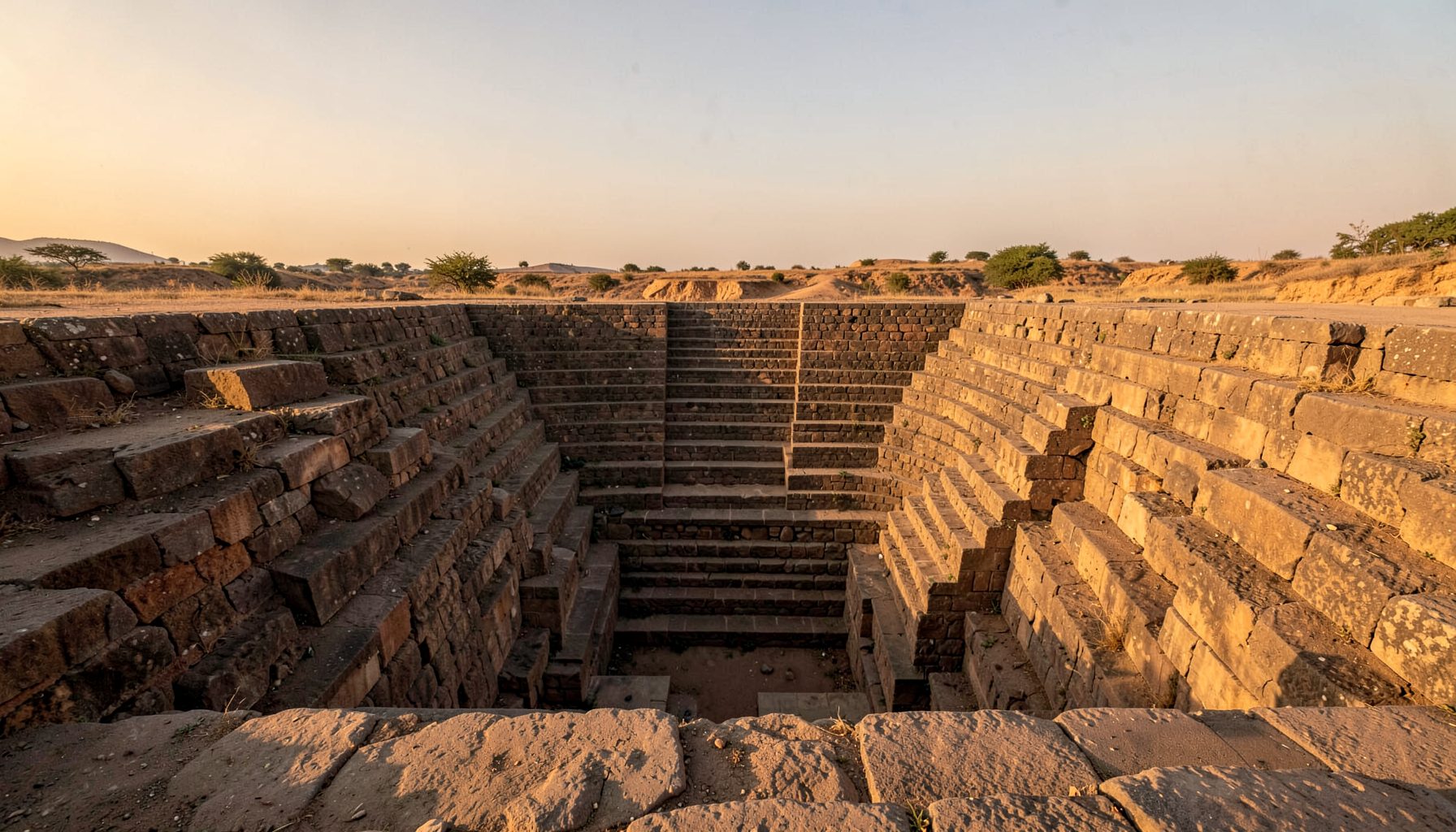
The Stepwells of the Konkan Railway Corridor: Documenting Before It’s Too Late is a field and photographic study of a landscape where modern railway engineering meets much older water-conservation traditions. Between Mumbai and the Konkan coast, settlements, farms and sacred sites once relied on stepped access to groundwater. Many bawdis, vavs and kunds now survive as fragments, often without a sign, a surveyed location or a public account of their history.
Documenting this heritage requires more than mapping a line. It means recording who uses a structure, how monsoon water moves through it, where stone has fallen and which local memories remain unrecorded. Indian Stepwells combines photography, measured sketches, drone views and field interviews to build an accessible archive for preservation, exhibitions and future research, with communities visible in how their water heritage is represented.
A railway line through an older water landscape
The present Konkan railway, which began full operation in 1998, belongs to a much older landscape of travel between Mumbai, the Sahyadri foothills and the Arabian Sea. Its alignments cross Thane, Raigad and Ratnagiri districts, linking settlements already organised around wells, tanks, roads and sacred places. Surveyors must connect modern track with older paths and lost water points, rather than treat the railway as the beginning of local history.
Railway construction can also alter the setting of a heritage structure. New embankments, cuttings and drainage works may redirect runoff, isolate an old approach or change the view from a station. Historic maps, track records and local accounts can reveal those relationships, while contemporary field observation can show where erosion or encroachment now threatens them.
The value of route-based observation can be seen in the wartime field records from Vietnam, where movement and place are documented together. The comparison is methodological, not geographic. Konkan researchers can apply the principle: understand each station, settlement and stepwell as part of a connected corridor, not a series of isolated monuments.
Reading local names and regional patterns
Local names provide the first clue to function and status. A bawdi often denotes a stepped neighbourhood well; a vav or vavli may describe a deeper reservoir; a kund may refer to a stepped tank associated with worship. These categories overlap, so a catalogue should preserve local usage instead of forcing every structure into one type. Sketches can compare corbelled supports, carved niches, landings and later repairs.
The wider Maharashtra campaign gives this corridor work a regional frame. Comparing a roadside well with an extensive tank near a market or shrine can reveal how water supply, population and ritual overlapped. The purpose is connection rather than a ranking of monuments by size, and photographs should show how each structure belonged to a working landscape.
Mapping should also distinguish a surviving stepwell from one buried beneath a road, house or altered field. Historic maps and oral histories can identify these losses, which often vanish from official lists. A careful record of absence helps explain urban growth, environmental change and the physical effects of railway building across the region.
Monsoon pressure and changing villages
A review of ancient stepwell technology helps place current climate pressure against older design principles: capture, slow, store and recharge. Those principles relied on shared rules for cleaning channels, repairing steps and managing access. They also depended on functioning catchments, making changes to drainage and groundwater use a serious threat to historic performance.
Konkan rainfall is concentrated between June and September, when short, intense bursts can fill a catchment quickly. Siltation, blocked inlets, road runoff and changing watercourses can now combine with longer dry periods. Some stepwells remain in daily use, while others have been abandoned or repurposed. Field notes should record present conditions rather than assume that a stepped structure still functions as a public well.
Water access also carries social histories. In some communities, a well has been a place for conversation, children’s routines and women’s work, as well as a source of supply. After piped water arrives, those uses may change without the stonework changing. Interviews with residents can recover practical knowledge about cleaning schedules, seasonal channels and local names, giving researchers a richer account than an empty courtyard would suggest.
What photography can and cannot prove
Wide photographs establish a stepwell’s position relative to rail embankments, village lanes and contemporary buildings. Ground-level views capture access, masonry and carving; measured sketches record geometry that a wide-angle lens can distort. Drone imagery can reveal roof plans, adjoining tanks and earthworks, but flights require permissions, safe launch points and respect for privacy and religious use.
An image is evidence, though it is not a complete survey. A steep descent does not establish a construction date, and a cut channel may be a later repair. Date claims need comparison with maps, inscriptions, materials and building details. Where those sources disagree, the archive should preserve that uncertainty rather than smooth it into a confident label.
Every record should retain original files, exact coordinates, dates, captions, weather conditions and permissions. Drawings should distinguish observed fabric from conjecture, while interviews should name the speaker and record consent. This discipline makes the collection useful for conservation: a conservator can compare changes over time, a researcher can test an old alignment, and a community can recognise the record as its own.
Why Australian comparisons matter
For Australian readers, the corridor’s railway setting has familiar echoes. Melbourne and Brisbane commuters know how a transport line can divide a neighbourhood from the landscape beyond it, while Sydney’s suburban railway makes historic cuttings and drainage channels part of the everyday cityscape. These comparisons shift attention from isolated monuments to ordinary places people pass every day.
Australian habits offer another point of contact. Many households in Melbourne and Sydney plan summer irrigation around council or water-authority rules, while rainwater tanks and drought-tolerant gardens have become familiar in suburban and regional life. The same practical concerns appear in buying contexts such as Adelaide’s Central Market and regional growers’ markets, where low-water gardening and water-efficient equipment compete for household budgets.
Legislation adds a legal comparison, though it cannot travel with the photographs. Built heritage in Victoria is protected under the Victorian Heritage Act 2017, while New South Wales uses the Heritage Act 1977 and the State Heritage Inventory; water management and council approvals add further layers. Indian fieldwork must follow Indian permissions and conservation requirements. Australian experience can inform archival practice and public interpretation without displacing local authority or community leadership.
A field protocol for urgent documentation
Urgency should sharpen standards, not replace them. Desk research can identify candidate sites from maps and local references, but a reliable assessment needs a visit, permission from the landowner and attention to safety near tracks and deep water. A dry-season visit reveals access and masonry; a monsoon-season visit, where safe, shows how water enters, moves and leaves a site.
The archive should receive corrections as readily as discoveries. Residents and custodians may know a well by another name, recognise a blocked approach or hold photographs explaining a lost feature. Indian Stepwells invites such contributions through share field observations, turning community knowledge into documented research material rather than an ornamental addition.
Survey priorities
- Record the site’s permissions, access rights and local custodian before entering water or moving stone.
- Capture fixed-point photographs in every accessible direction, using scale markers and a site diagram.
- Measure depth, platform levels, stair geometry, visible inlets and repair phases without disturbing deposits.
- Map the relationship to railway alignments, footpaths, tanks, shrines, channels and nearby construction.
- Log weather, water conditions, vegetation, safety risks and fresh flood or collapse damage.
Evidence to preserve
- Save original image files with location, date, direction, photographer and consent metadata.
- Keep measured sketches beside photographs, marking uncertainty instead of guessing a construction date.
- Transcribe oral accounts with permission and record how the speaker chose the wording.
- Catalogue archival maps, railway records and earlier reports, including their source and known gaps.
- Agree with residents where sensitive material should be stored and who may access it.
The railway may carry visitors through the region, but the stepwells preserve a deeper civic history of shared water, negotiated access and memory held in stone. Their future will be decided where those records meet local stewardship. Precise documentation cannot substitute for conservation, yet it can give communities and advocates a stronger basis for protecting it.
Get in Touch
Have information about a stepwell that is not yet on our map? We would be glad to document it and give you full credit. Whether it is a Barav, Kund, Vihir, or any other form of stepwell, every contribution helps preserve India's water heritage.
Call or message us with details about the location, and we will follow up.
#9372496819
Send a Message
What People Say
"The Maharashtra Stepwells campaign has brought attention to structures that were nearly forgotten. The architectural documentation and drone photography are invaluable resources for researchers and students alike."
"Collaborating with the Indian Stepwells team gave our architecture students hands-on exposure to traditional water-harvesting structures. The presentations were insightful and inspiring."
"I shared details of a stepwell near my village that was not on any map. The team visited, documented it beautifully, and credited me. It felt wonderful to contribute."