 Explore Maharashtra
Stepwells of the Godavari delta: water, memory and neglect
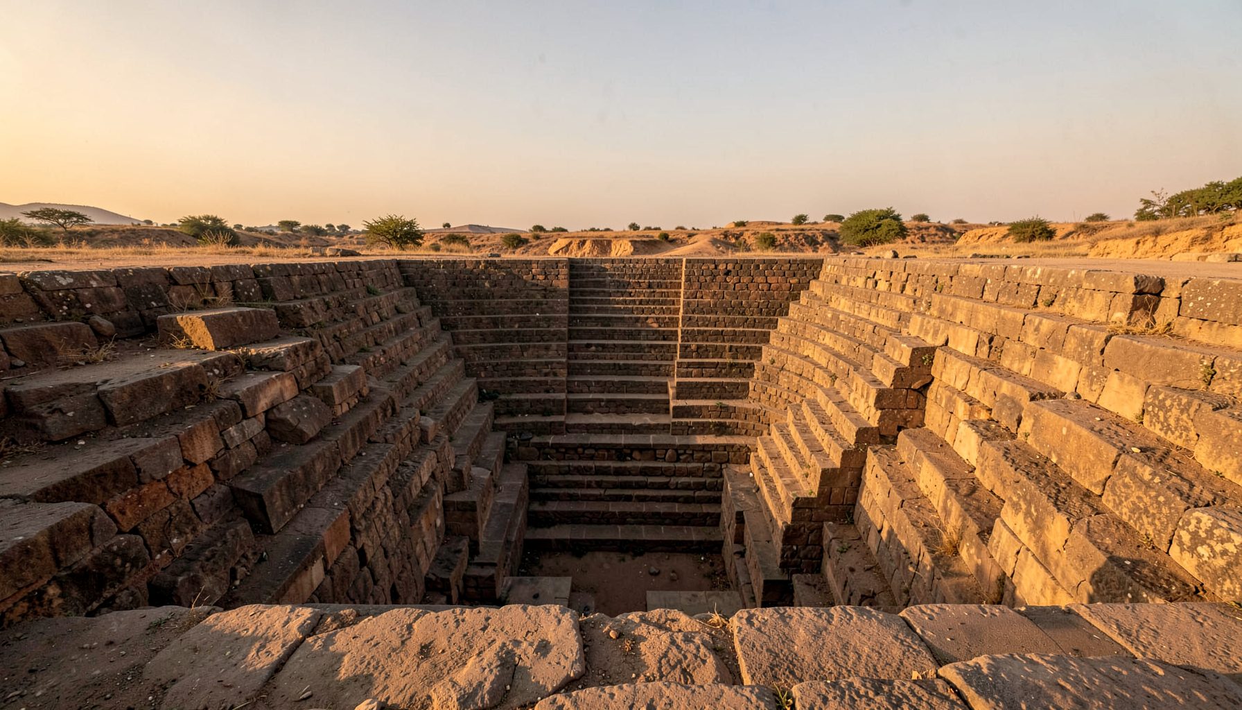
The Stepwells of the Godavari Delta: A Rich but Neglected Site is more than a regional landmark. Across Maharashtra’s lower river landscape, historic kunds, bawdis, baolis and vavs preserve generations of ingenuity in rainwater harvesting, groundwater management and climate-sensitive architecture. Their stepped passages, chambers and water courts once connected daily life with the monsoon, while their stonework records skills passed between communities for centuries.
Many remain outside formal heritage lists, and some survive only through local memory. Yet their architectural richness is matched by an equally significant story of changing water access, environmental pressure and public neglect. Original photography, measured sketches, field notes and oral testimony can reveal how these structures functioned and why their conservation deserves greater attention.
A river landscape written in stone
The Godavari delta is shaped by extraordinary seasonal variation. Monsoon rain fills streams and floodplains, while tidal channels distribute water toward the Arabian Sea. In drier months, wells and stepwells become essential links between villages and groundwater. This alternation between abundance and scarcity encouraged water-harvesting architecture adapted to local soils, settlement patterns and rainfall.
Their forms vary with the terrain. Deep masonry tanks descend through flights of steps; roofed galleries provide cooler access to water; open kunds hold larger volumes; and modest village bawdis serve nearby communities. Basalt, laterite and lime mortar were combined according to local availability. In lower, wetter reaches, deep structures and shaded corridors helped manage heat and flooding.
These were also social landscapes. A well could be a workplace, meeting place, resting point and neighbourhood landmark. Architecture shaped encounters between people and water, sometimes reflecting strict customs about access and use. Protecting only the visible monument, however, removes the community relationships that give it meaning.
Many forms along the Godavari landscape
Upstream in the wider Godavari basin, Gangapur Kund near Parner demonstrates the scale possible in Maharashtra. Broad flights of masonry steps lead into a deep tank, and the monument is often described as one of the state’s largest historic kunds. Its architecture belongs to a regional water tradition extending across the Deccan, where communities built elaborate reservoirs before modern pipe networks became available.
Closer to the lower basin and coastal settlements, local names such as vav, baoli, bawdi and kund continue to appear in oral records and village maps. These terms do not always correspond neatly to a single architectural category; they may reflect a structure’s shape, use, water source or local language. A reliable survey therefore records names as well as dimensions.
Further west, Jodhpur’s shaded stepwell oasis shows how a dry climate can concentrate spectacular public water architecture. The contrast with the Godavari region is instructive: Rajasthani stepwells emphasise shade and monumental geometry, while deltaic examples often merge more closely with floodplains, vegetation and dispersed village life.
Why careful documentation is urgent
Neglect often begins with altered water. Pumping from tube wells, intensified groundwater extraction and changes to drainage have transformed relationships that once sustained stepwells. Silt, invasive plants and damaged masonry follow, while roads, expanding settlements and untreated runoff can isolate a structure from the community that used it.
The independent, photograph-led method set out in the project’s field approach treats each site as architecture, ecology and community history rather than picturesque scenery. That distinction matters. A structure may look intact in a wide-angle photograph yet have unsafe steps, blocked outlets, contaminated water or no locally understood name.
A useful record combines visual and documentary evidence: elevations, access routes, seasonal water levels, vegetation, repair materials and changing land use. Drone imagery can reveal spatial relationships, but it cannot replace being present at ground level. Local observations often explain what a plan cannot, especially where paths, channels and property boundaries have shifted.
Water tanks as social memory
Stepwells were civic rooms before they were monuments. People collected water, washed animals, performed ritual ablutions, rested in shade and exchanged news. In many societies, customs determined who could gather at a well and when, making architecture inseparable from questions of dignity, authority and belonging.
A parallel from another cultural landscape comes from Waterford’s Quaker burial customs, where restrained graves expressed a commitment to plainness and collective remembrance. Although burial grounds and water tanks serve different purposes, both demonstrate that landscapes can hold shared values without elaborate display. Their meaning lies in use, conduct and memory.
That memory is often held by residents rather than institutions. A retired farmer may remember an older water route; a potter may know the name of a vanished tank; a school group may possess old photographs. Oral histories can identify vanished structures and explain changing access. Combined with physical survey, they produce a richer account than an inventory of monuments alone.
Australian parallels for water-sensitive heritage
For Australian readers, the most immediate connection is water anxiety. Sydney’s reservoirs and catchments illustrate the political importance of secure water supplies, while Melbourne’s water-conscious gardening and community plots show how conservation becomes part of ordinary domestic life. Adelaide’s long relationship with the River Torrens offers another model: a city shaped by the tension between a dry climate and the promise of a reliable civic water system.
Seasonal experience is reversed, with Australian summer arriving while the Maharashtra monsoon retreats. In Brisbane, wet-season mango production moves through growers’ markets and local produce stalls, linking water, food and regional trade. Australian historical societies, volunteer survey groups and camera clubs also offer a familiar model for community-led heritage recording, though the purpose must remain tied to the place being documented.
Useful parallels for Australian field teams include:
- Mapping how water structures connect residential areas, farms, religious spaces and public gathering places
- Recording shade, ventilation and thermal comfort alongside architectural form
- Tracing relationships between wells, food production and seasonal markets
- Cooperating with local historical societies and resident photographers without displacing local authority
These comparisons sharpen observation without turning Indian structures into scenery or replicas. Their significance remains rooted in local use, environmental adaptation and community memory.
From survey to community stewardship
Preservation should begin with recognition as well as repair. Indian Stepwells encourages local communities to identify undocumented stepwells, and that invitation is grounded in a practical truth: residents often know the location, name and history of places missing from official records. Their knowledge can guide priorities and prevent restoration from erasing later, less formal layers of use.
A field record should be clear enough for future researchers and accessible enough for local custodians. Detailed photographs need orientation, dates and captions, while sketches should explain levels, construction and relationships that a photograph alone may obscure. Notes on water conditions and structural safety are equally valuable.
A practical field record should include:
- Exact location, local names, access conditions and the names of people consulted
- Overall views, details of steps, outlets, chambers, masonry and surviving water
- Seasonal water behaviour, ecological conditions, damage and previous repairs
- A clear distinction between verified evidence, historical information and unresolved questions
Taken together, these records can reveal a stepwell as a working part of a living water system. For the Godavari delta, documentation is the first stage of stewardship: a way to preserve not only ancient stone, but also the knowledge and community relationships that made each structure matter.
Get in Touch
Have information about a stepwell that is not yet on our map? We would be glad to document it and give you full credit. Whether it is a Barav, Kund, Vihir, or any other form of stepwell, every contribution helps preserve India's water heritage.
Call or message us with details about the location, and we will follow up.
#9372496819
Send a Message
What People Say
"The Maharashtra Stepwells campaign has brought attention to structures that were nearly forgotten. The architectural documentation and drone photography are invaluable resources for researchers and students alike."
"Collaborating with the Indian Stepwells team gave our architecture students hands-on exposure to traditional water-harvesting structures. The presentations were insightful and inspiring."
"I shared details of a stepwell near my village that was not on any map. The team visited, documented it beautifully, and credited me. It felt wonderful to contribute."