 Explore Maharashtra
The Stepwells Of The Chola Heartland: An Overlooked Legacy
When people picture an Indian stepwell, they often imagine the deep, geometric vavs of Gujarat or the baolis of Rajasthan. Those monuments are spectacular, carefully framed by flights of stairs and galleries. In the Chola heartland of Tamil Nadu, however, water architecture usually appears through a broader and less easily classified family of structures: temple tanks, stepped reservoirs, stone-lined wells, bathing ghats, irrigation ponds and sunken access points beside village water bodies.
This landscape developed across the fertile Kaveri delta and the wider Tamil country from the early medieval period onwards. Chola rulers, temple authorities, merchant groups and village assemblies all participated in systems that stored, moved and shared water. The result was not a single, recognisable style of stepwell, but a network of hydraulic places woven into agriculture, worship, settlement and seasonal life.
For an Australian audience, the comparison is especially useful. A rainwater tank, town reservoir or irrigation channel is rarely judged only as an object; its value lies in the system around it. The same is true of a South Indian stepped tank. Its masonry matters, yet so do catchment paths, sluices, festival use, groundwater levels, shade trees and the communities that maintain or remember it.
The Chola legacy therefore deserves attention as a water-conservation tradition rather than as a search for famous monuments alone. Some structures may be grand temple tanks, while others are modest wells obscured by vegetation, road widening or later construction. Together, they reveal how engineering and ritual shaped the everyday geography of the Tamil region.
Water Architecture In The Kaveri Delta
The Chola core covered much of present-day Tamil Nadu, with Thanjavur, Kumbakonam, Gangaikonda Cholapuram and the lower Kaveri basin forming important political and cultural centres. Seasonal monsoon rainfall made storage essential. Rivers, canals, tanks and wells helped convert an unpredictable supply into dependable irrigation for rice cultivation, gardens and domestic use.
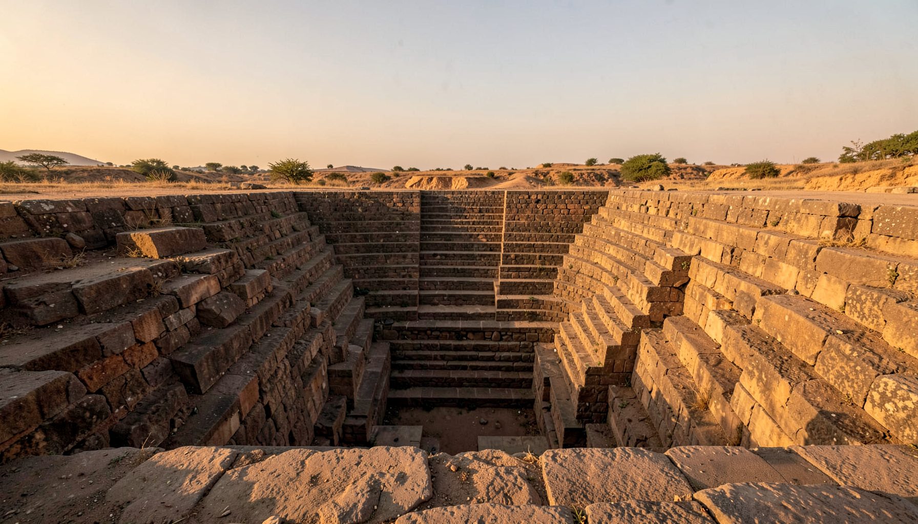
Many water structures associated with Chola-period settlements were connected to temples. A temple tank could provide water for ritual bathing, processions and festivals, while also serving as a groundwater recharge zone and a civic gathering place. Broad flights of steps allowed people to reach changing water levels. Pavilions, retaining walls, shrines and stone embankments gave these sites an architectural presence similar to a stepwell, even when they were open tanks rather than deep, enclosed wells.
The Tamil word kulam may refer to a pond or tank, while terms such as eri describe larger irrigation reservoirs. A pushkarini or temple tank belongs to a sacred setting, although local terminology varies. Treating every stepped water structure as a western Indian baoli can hide these distinctions. The important question is how the structure worked within its landscape.
Why The Southern Stepwell Story Is Harder To See
The most famous Chola monuments are temples, inscriptions and sculptures, so water infrastructure often receives less attention in popular heritage writing. Tanks can also appear visually plain after repairs, cement rendering or the removal of original steps. In a photograph taken during a dry season, a large reservoir may look like an empty pit rather than a sophisticated hydraulic machine.
Historical continuity creates another difficulty. A tank may contain Chola foundations, Nayaka additions, colonial repairs and modern concrete interventions. Dating a single wall or staircase without examining inscriptions, masonry patterns, water channels and local oral history can lead to false certainty. A careful record should distinguish what is visible from what is inferred.
This is where independent heritage documentation becomes valuable. A project such as mapping lost wells demonstrates how overlooked water structures can be located through field visits, historic maps, satellite imagery and community knowledge. Similar methods could bring more attention to Tamil Nadu’s lesser-known tanks and stepped wells.
Reading A Chola Water Site
A useful field visit begins beyond the staircase. Researchers can trace where rainwater enters, identify feeder channels, inspect spillways and note the relationship between the tank and nearby fields. The settlement’s elevation, soil, vegetation and access roads may explain why a particular structure was placed there. Drone imagery can reveal embankments and geometric alignments that are difficult to read from ground level.
In Australia, people are accustomed to checking dam levels, water restrictions and catchment conditions through council or state services. That practical habit offers a helpful way to approach historic Indian water systems: ask what the structure collected, who controlled it, when it filled and how overflow was managed. Sydney’s stormwater channels, Adelaide’s water-sensitive urban design and Melbourne’s rain gardens show that water infrastructure can be both technical and publicly visible.
Documentation should also be cautious about access. A temple tank may remain an active sacred place, and a village well may sit on private or community-managed land. Permission, modest clothing, respectful photography and consultation with local residents are more important than obtaining a dramatic image. For researchers comparing different evidence traditions, a concise battle account can even illustrate a wider archival principle: eyewitness material, maps and later interpretations must be separated rather than blended into one unquestioned story.
Clues For Identifying A Historic Stepped Water Structure
An apparently ordinary tank or well may preserve important evidence. The following clues do not prove a Chola date by themselves, but they help guide a closer survey:
- Granite steps with consistent proportions, worn edges or carefully fitted joints
- Stone revetments that differ from later brick, concrete or cement repairs
- Inscriptions, sculptural fragments, donor panels or reused temple masonry
- Channels, sluices and overflow points aligned with fields or settlement streets
- Oral traditions connected with festivals, processions, bathing or village assemblies
A site’s relationship with a temple should be recorded without assuming that every nearby tank was built at the same time. Some reservoirs were enlarged repeatedly, and some sacred tanks may occupy older water-harvesting locations. Comparing stonework, plans, inscriptions and historical imagery can establish a more reliable sequence.
The distinction between survival and visibility also matters. A stepped ghat may be buried below silt, while a modern road may have cut through its feeder channel. In agricultural districts, a tank’s functioning embankment may be more historically significant than an attractive but isolated staircase. Heritage value belongs to the whole water system.
What A Field Record Should Capture
Good documentation combines photographs with measurements and written observations. A useful record might include:
- Coordinates, orientation, dimensions and the date and season of the visit
- A sketch plan showing steps, platforms, channels, shrines and access routes
- Masonry details, construction materials, repairs and signs of water damage
- Current use, ownership, maintenance practices and local names
- Interviews with residents, temple staff, farmers and municipal or panchayat workers
Photography should cover the ordinary as well as the monumental: algae lines, blocked drains, discarded pipes, tree roots and patched steps can reveal how a site has changed. A short video can record the sound of water, the movement of people and the scale of the surrounding landscape, provided filming does not disrupt worship or private activity.
Digital presentation also needs judgement. Heritage websites, social media galleries and even unrelated entertainment platforms compete for attention, so clear captions and source notes are essential. A page about free video slots belongs to a different online category, but the contrast makes the point: visual appeal should never be allowed to blur the difference between documented evidence and promotional content.
Preservation Between Temple, Village And State
Preservation is rarely a matter of repairing stone alone. A tank may need desilting, a functioning inlet, control of invasive vegetation and protection from sewage or solid waste. If local users still depend on it, a conservation plan must support practical needs rather than turn a living water place into a fenced display.
Legal protection varies across India, and local authorities, temple administrations and community institutions may have overlapping responsibilities. Australian readers may recognise a comparable tension under frameworks such as the NSW Heritage Act 1977 or the Environment Protection and Biodiversity Conservation Act 1999: listing can raise awareness, but effective care still depends on funding, management and public consent.
Research and public interpretation can help shift attention towards these less celebrated monuments. The Maharashtra campaign offers a model for combining photography, fieldwork and awareness around regional water heritage. A comparable effort in the Chola heartland could link major temple towns with smaller villages, documenting tanks that do not appear in standard tourist itineraries.
For visitors from Australia, this is also a reminder to look beyond the heritage market’s most recognisable images. A restored stepwell may attract tour groups and photographers, while a neglected tank may retain greater evidence of working water management. Supporting responsible guides, local researchers, conservation organisations and community-led interpretation can help ensure that attention benefits the places being documented. The Chola water landscape is not a vanished curiosity; it is a dispersed archive whose surviving stones, channels and memories still deserve careful reading.
Get in Touch
Have information about a stepwell that is not yet on our map? We would be glad to document it and give you full credit. Whether it is a Barav, Kund, Vihir, or any other form of stepwell, every contribution helps preserve India's water heritage.
Call or message us with details about the location, and we will follow up.
#9372496819
Send a Message
What People Say
"The Maharashtra Stepwells campaign has brought attention to structures that were nearly forgotten. The architectural documentation and drone photography are invaluable resources for researchers and students alike."
"Collaborating with the Indian Stepwells team gave our architecture students hands-on exposure to traditional water-harvesting structures. The presentations were insightful and inspiring."
"I shared details of a stepwell near my village that was not on any map. The team visited, documented it beautifully, and credited me. It felt wonderful to contribute."