 Explore Maharashtra
The Stepwells of the Chambal Valley: A Remote Expedition
The Chambal Valley is usually pictured as a landscape of ravines, river bends and dry scrub rather than as a centre of architectural heritage. Yet across the wider Chambal region, old baolis, bawdis, kunds and village wells reveal how communities once managed heat, monsoon uncertainty and long journeys between settlements. Some are prominent masonry monuments; others survive as eroded stairways beside farms, temples or abandoned tracks.
For visitors from Australia, the landscape can feel both unfamiliar and strangely recognisable. Anyone who has watched water restrictions shape daily life in Melbourne, Sydney or regional New South Wales will understand why a carefully engineered water structure mattered so deeply. A remote expedition into this valley is therefore more than a search for picturesque ruins. It is an attempt to read hydrology, architecture, memory and current land use together.
Following water through the ravines
The Chambal River flows through Madhya Pradesh, Rajasthan and Uttar Pradesh, cutting a broad corridor through deeply incised ravines. Seasonal streams, sandy banks and uneven roads make travel slow, particularly after rain. A stepwell survey cannot rely on a simple list of monuments because many structures are known by local names, family associations or directions such as “behind the old shrine”.
The most useful starting point is the water system itself. A baoli may sit near a former caravan route, while a kund could be associated with ritual bathing or a temple complex. The staircase, retaining walls and underground chambers often indicate how water levels changed through the year. Measuring orientation, access points and the relationship between the structure and nearby drainage can reveal more than a quick photograph from the entrance.
The valley’s remoteness also affects preservation. Dense vegetation can hide a descent, while collapsed edges may be dangerous for researchers and livestock. In several locations, modern bore wells and concrete tanks have replaced older communal systems. The surviving stepwell may therefore appear isolated, even though it once formed part of a much larger settlement landscape.
Reading a stepwell as architecture
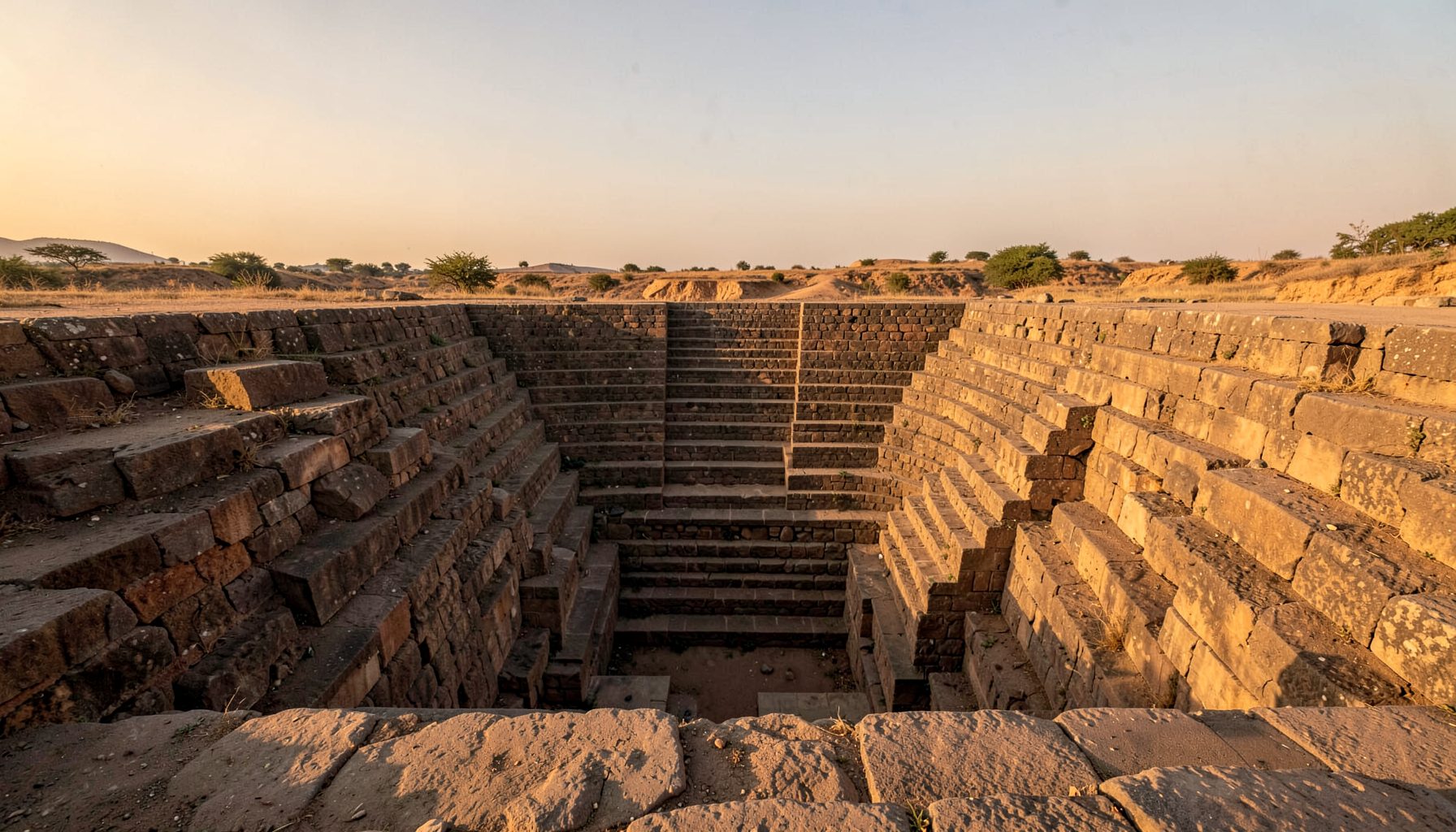
A stepwell is a designed experience of descent. Repeated flights of stairs reduce the distance between the visitor and the water, while landings provide shade and spaces for rest, conversation or religious observance. Pillars, brackets, carved niches and retaining masonry can help identify regional influences, construction phases and later repairs.
In the Chambal Valley, field notes should distinguish original fabric from additions made in cement or brick. A repaired parapet may carry practical value for local users, while a damaged carved panel can provide evidence about the structure’s age and status. Drone imagery is useful for understanding the plan, but it should complement ground photography rather than replace close observation of tool marks, joints and erosion.
The photographer’s position matters as well. A wide image can establish the stepwell’s setting among ravines and fields, while a low-angle view can communicate the geometry of the descent. Sketches are especially valuable where shadows conceal details or where vegetation makes a complete photograph impossible. The aim is to create a record that can be checked, compared and understood years after the expedition.
A journey shaped by local knowledge
Remote heritage work depends on relationships. Farmers, temple caretakers, schoolteachers and village elders may know of structures that do not appear in tourism brochures or online maps. Their information can lead researchers to a forgotten baoli, clarify a local name or explain why a particular staircase is still used during part of the year.
This approach has a useful parallel in Australia, where community-led documentation often works alongside formal heritage registers and local historical societies. A survey near Sydney or regional Victoria must consider landholder permission, cultural sensitivities and the requirements of legislation such as the Heritage Act 1977 in New South Wales or the Aboriginal Heritage Act 2006 in Victoria. The same principle applies in India: access is negotiated, local custodians are acknowledged and sensitive information is not casually published.
Digital publication should preserve that care. The Indian Stepwells project places photography and field research within a wider effort to educate the public and encourage information about undocumented water structures. A Chambal expedition can contribute to this kind of open record while still withholding precise locations where exposure could invite vandalism, unregulated tourism or theft.
Recording change in a dry landscape
The condition of a stepwell is inseparable from changing water practices. A structure may be dry because rainfall has shifted, groundwater has fallen, or a nearby channel has been blocked. It may also be neglected because a hand pump or borewell offers faster access. Recording these factors prevents the monument from being treated as an isolated architectural object.
Australian readers may recognise the tension. Household rainwater tanks, public water restrictions and everyday habits such as shorter showers make water conservation visible in cities and towns. The Australian market also shapes how heritage is encountered: weekend markets and local festivals can support community fundraising, yet increased visitor traffic can place pressure on fragile sites. In the Chambal, a small village fair or pilgrimage may similarly provide income while creating waste, trampling and unmanaged access.
Field teams should record rubbish, vegetation growth, recent construction, water quality and evidence of active use. Photographs taken from the same points on repeated visits can show whether walls are settling or stairs are being cleared. GPS data, sketches and interviews create a stronger archive when combined, especially where official records are incomplete.
The digital environment requires equal attention. Heritage researchers should separate reliable field evidence from promotional material and unrelated commercial content; even a page discussing a loyalty bonus belongs to a different information category from a surveyed monument. Clear source evaluation helps readers understand which claims come from observation, oral history, archival material or interpretation.
Planning a careful expedition
A remote survey requires more preparation than a conventional sightseeing trip. Roads may be unmarked, mobile coverage inconsistent and shade limited. The expedition should include sufficient water, sun protection, first-aid supplies, offline maps, spare batteries and a plan for communicating with a local contact. Travel schedules need generous margins because a short distance across ravine country can consume most of a day.
Drone use must be handled responsibly. In Australia, operators are familiar with CASA requirements governing airspace, safety and privacy; visitors bringing that mindset to India should also check current Indian rules, permissions and local restrictions before launch. A drone should never be flown over people, religious activity or private compounds without consent. Ground-level images often provide the most respectful and informative record.
A useful field protocol can keep the work consistent:
- Confirm access and photography permissions with local custodians before entering.
- Record the structure’s local name, approximate location, setting and apparent function.
- Photograph entrances, stair flights, landings, water chambers, drainage and damage.
- Make a quick measured sketch showing orientation, levels and significant architectural details.
- Interview more than one informed person and note differing accounts rather than forcing agreement.
- Back up images, notes and GPS data each evening in separate locations.
- Share results with local communities and avoid publishing sensitive details without discussion.
The mystery of a hidden passage can be especially compelling, as shown by the account of Bhongir’s secret tunnel. Such features should be approached with restraint: an intriguing story is a reason to investigate carefully, not an invitation to enter unstable chambers or turn a living site into an adventure attraction.
A remote expedition through the Chambal Valley can reveal how water architecture survives beyond the familiar monuments of Gujarat or Rajasthan. Its value lies in patient observation: following paths, listening to local accounts, comparing masonry and documenting the pressures that shape each site today. The resulting archive can help transform overlooked wells into recognised parts of India’s environmental and cultural history, while keeping the people and landscapes connected to them at the centre of the record.
Get in Touch
Have information about a stepwell that is not yet on our map? We would be glad to document it and give you full credit. Whether it is a Barav, Kund, Vihir, or any other form of stepwell, every contribution helps preserve India's water heritage.
Call or message us with details about the location, and we will follow up.
#9372496819
Send a Message
What People Say
"The Maharashtra Stepwells campaign has brought attention to structures that were nearly forgotten. The architectural documentation and drone photography are invaluable resources for researchers and students alike."
"Collaborating with the Indian Stepwells team gave our architecture students hands-on exposure to traditional water-harvesting structures. The presentations were insightful and inspiring."
"I shared details of a stepwell near my village that was not on any map. The team visited, documented it beautifully, and credited me. It felt wonderful to contribute."