 Explore Maharashtra
Bhongir’s hidden water passage and the mystery beneath the fort
Bhongir rises from the Telangana plain as a single, dark granite hill, its fortifications wrapped around an almost otherworldly outcrop. From a distance, the fort looks like a natural stronghold. Closer inspection reveals gates, steep stone steps, rock-cut chambers, cisterns and defensive walls shaped around the hill’s difficult contours. Learn more about A Comparison Of Stepwell Types Baoli Vav Kund And Barav.html.
Local stories add another layer to this landscape: a concealed tunnel running beneath or through the fort. Some versions describe an escape route for rulers, while others connect it with distant strongholds or hidden chambers. The tale has endured because Bhongir is full of spaces that are hard to read at a glance—blocked passages, shadowed clefts and water structures cut directly into the rock.
The idea of a secret tunnel is especially compelling in a place built around water security. A hill fort could withstand attack only if it stored drinking water, managed runoff and protected access to its cisterns. What appears to be a mysterious passage may therefore relate to drainage, maintenance, storage or movement within the fort rather than a dramatic underground road.
For Australian readers used to seeing heritage interpreted through National Trust listings, council signage or a well-marked walk near Sydney and Melbourne, Bhongir offers a different experience. The evidence is fragmented, oral history remains important, and the boundary between a documented feature and a popular legend needs to be handled carefully.
A granite fortress above the Deccan plain
Bhongir, also written Bhuvanagiri, stands in present-day Telangana, east of Hyderabad. The fort occupies a massive isolated hill whose slopes rise abruptly from the surrounding countryside. Its position provided an exceptional defensive advantage: approaching armies could be seen across the open plain, while the narrow ascent forced visitors through controlled gateways and steep routes.
The stronghold is generally associated with the Western Chalukya ruler Tribhuvanamalla Vikramaditya VI, who ruled in the late eleventh and early twelfth centuries. Later dynasties and regional powers altered, repaired and reused the site. As with many Indian forts, the surviving fabric is layered rather than attributable to a single building phase.
The climb reveals how architecture follows geology. Steps are cut into or laid across the granite, walls cling to ridges, and openings are positioned to control movement. The hill’s natural cavities could be adapted into shelters, lookout points or water-holding spaces. These features make it difficult to identify the original purpose of every hollow or narrow opening from surface observation alone.
What the tunnel story may be hiding
Bhongir’s tunnel legend belongs to a wider South Asian tradition of underground routes linking palaces, forts, temples and water installations. Some such passages were genuine, particularly short routes used for drainage, service access or escape. Others became enlarged in popular memory, transforming a practical corridor into a passage running for kilometres beneath the landscape.
A proposed connection with Golconda Fort is often repeated in discussions of Bhongir, although the distance and terrain make a direct, continuous tunnel difficult to accept without strong archaeological evidence. A more plausible explanation could involve a short internal passage, a concealed stairway or a blocked channel whose original function has been forgotten.
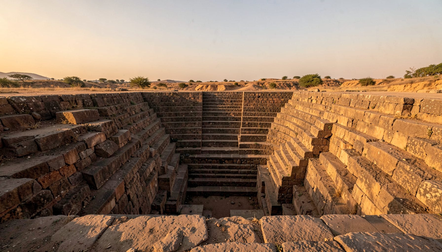
The water system deserves equal attention. Stepwells, rock-cut tanks and cisterns were designed to capture monsoon rainfall and retain it through the dry season. Readers wanting a useful comparison of the terms can explore this guide to baoli, vav, kund and barav, because a fort cistern is not automatically a stepwell in the architectural sense.
Clues that can separate structure from legend
- A passage aligned with a cistern, drain or catchment surface
- Masonry changes showing later repairs or blocked entrances
- Ventilation shafts, handholds or steps indicating regular use
- Water-worn surfaces suggesting drainage rather than secret travel
- Oral accounts that name the feature consistently across generations
A careful field record should distinguish what can be seen from what has been inferred. A narrow opening may be called a tunnel by local visitors, yet its dimensions, slope and relationship to the hill could indicate a culvert or storage feature. Photography, measured sketches, drone imagery and archival maps can gradually test those interpretations.
Why hidden spaces matter in heritage research
Mystery attracts attention, but it can also flatten history. When a fort is marketed only as the site of a secret passage, its water engineering, labour systems and changing political use may disappear behind a dramatic headline. Bhongir is more valuable when the legend becomes a starting point for investigation rather than the final explanation.
This approach has parallels in heritage work beyond India. Accounts of concealed burial places, erased institutions and unmarked sites can reveal how communities remember difficult histories. The discussion of unmarked graves in Dublin shows why documentation must include absence, silence and contested memory, not just impressive surviving buildings.
For an Australian audience, the comparison may resonate with Aboriginal cultural sites, convict-era remains and places where official signage tells only part of the story. A heritage walk around The Rocks in Sydney, an old goldfield in Victoria or a regional cemetery in South Australia can raise similar questions: who recorded the site, whose account was excluded, and what evidence remains in the landscape?
The same principle applies to online publishing. Readers may discover a heritage story while browsing entirely different subjects, including guides for Australian casino players. Clear captions, source notes and restrained language can turn that unexpected visit into an encounter with serious cultural research rather than another exaggerated travel claim.
Reading Bhongir through its water architecture
The most productive way to approach the tunnel mystery is to study the entire hydraulic landscape. A fort on an isolated granite hill needed more than walls and weapons. Rainfall had to be directed into tanks, drinking water protected from contamination, and overflow controlled so that heavy monsoon storms did not damage paths or foundations.
This is where Bhongir can be compared with stepwells in Rajasthan, Gujarat and Maharashtra while still being recognised as a distinct fort environment. A formal vav or baoli usually creates a monumental descent towards groundwater or stored water. A hill-fort cistern may be smaller, more irregular and cut into living rock, yet it reflects the same broad principle: survival depends on designing for seasonal scarcity.
Features worth documenting on site
- The direction of channels leading towards rock-cut tanks
- Sediment lines that indicate historic water levels
- Tool marks on steps, walls and carved basins
- Covered or shaded sections that may have protected stored water
- The relationship between gates, living quarters and reservoirs
Australian visitors may find the seasonal logic familiar even though the materials and climate differ. Water restrictions in Melbourne, drought planning around regional New South Wales and the careful management of catchments in Western Australia all demonstrate that water infrastructure shapes settlement. Bhongir makes that principle visible in stone, at a scale where defence and water conservation are inseparable.
Visiting, recording and sharing the evidence
A responsible visit begins with the assumption that the hill is a living heritage site, not an adventure set. Loose masonry, steep surfaces and unprotected edges can make the ascent hazardous. Heat is also a serious consideration, particularly outside the cooler months. Visitors accustomed to a bright Melbourne arvo or a walk around Brisbane should remember that exposed granite can intensify the Telangana sun, while shade and water may be limited.
The best documentation combines wide images with close details. A drone photograph can show how the fort, slopes and nearby settlement relate to one another, while a hand sketch may capture a blocked opening more clearly than a distant image. Notes should include the date, approximate location, light conditions, local names and whether an observation came from direct inspection or a spoken account.
Questions for a careful field record
- Is the feature accessible, blocked or partly collapsed?
- Does its route follow the natural slope of the hill?
- Are there signs of water flow, smoke, foot traffic or masonry repair?
- Who shared the story, and are there different versions locally?
- Has an archaeological report, map or conservation survey mentioned it?
Documentation becomes stronger when local knowledge is credited rather than treated as an obstacle to expert research. Residents, guides and caretakers may know names for tanks, gates and paths that do not appear in tourist brochures. Their memories can identify overlooked features, while measured observation can test how those stories relate to the physical site.
The Indian Stepwells project welcomes information about undocumented water structures and related heritage locations through its research contact page. Bhongir’s hidden passage may eventually be clarified by a conservation survey, geological study or newly located archival reference. Until then, the mystery has value precisely because it encourages closer attention to the fort’s stonework, water systems and living memories.
Get in Touch
Have information about a stepwell that is not yet on our map? We would be glad to document it and give you full credit. Whether it is a Barav, Kund, Vihir, or any other form of stepwell, every contribution helps preserve India's water heritage.
Call or message us with details about the location, and we will follow up.
#9372496819
Send a Message
What People Say
"The Maharashtra Stepwells campaign has brought attention to structures that were nearly forgotten. The architectural documentation and drone photography are invaluable resources for researchers and students alike."
"Collaborating with the Indian Stepwells team gave our architecture students hands-on exposure to traditional water-harvesting structures. The presentations were insightful and inspiring."
"I shared details of a stepwell near my village that was not on any map. The team visited, documented it beautifully, and credited me. It felt wonderful to contribute."