 Explore Maharashtra
Stepwells of the Banas River basin: a heritage trail
The stepwells of the Banas River basin form a heritage trail through Rajasthan’s Aravalli country. They are not isolated monuments but parts of a system that moved monsoon rain from uplands to fields, settlements and travellers. Their architecture records how communities shared water, marked faith and valued shade in a seasonal climate.
Visiting them changes the scale of a journey. A deep baoli beside a temple, a modest village kund and a long flight of steps can share a civic landscape while serving different needs. The trail links familiar sites with lesser-recorded structures and asks visitors to see architecture, ecology and community memory as one story.
Following the river’s logic
The Banas rises near Khamnor in the Aravalli hills, flows past Rajsamand and through Tonk district, and meets the Chambal. Its basin includes the Banganga corridor, where many celebrated stepwells stand. The distinction matters: Chand Baori and Harshat Mata near Abhaneri belong to the Banganga system, not the Banas main channel.
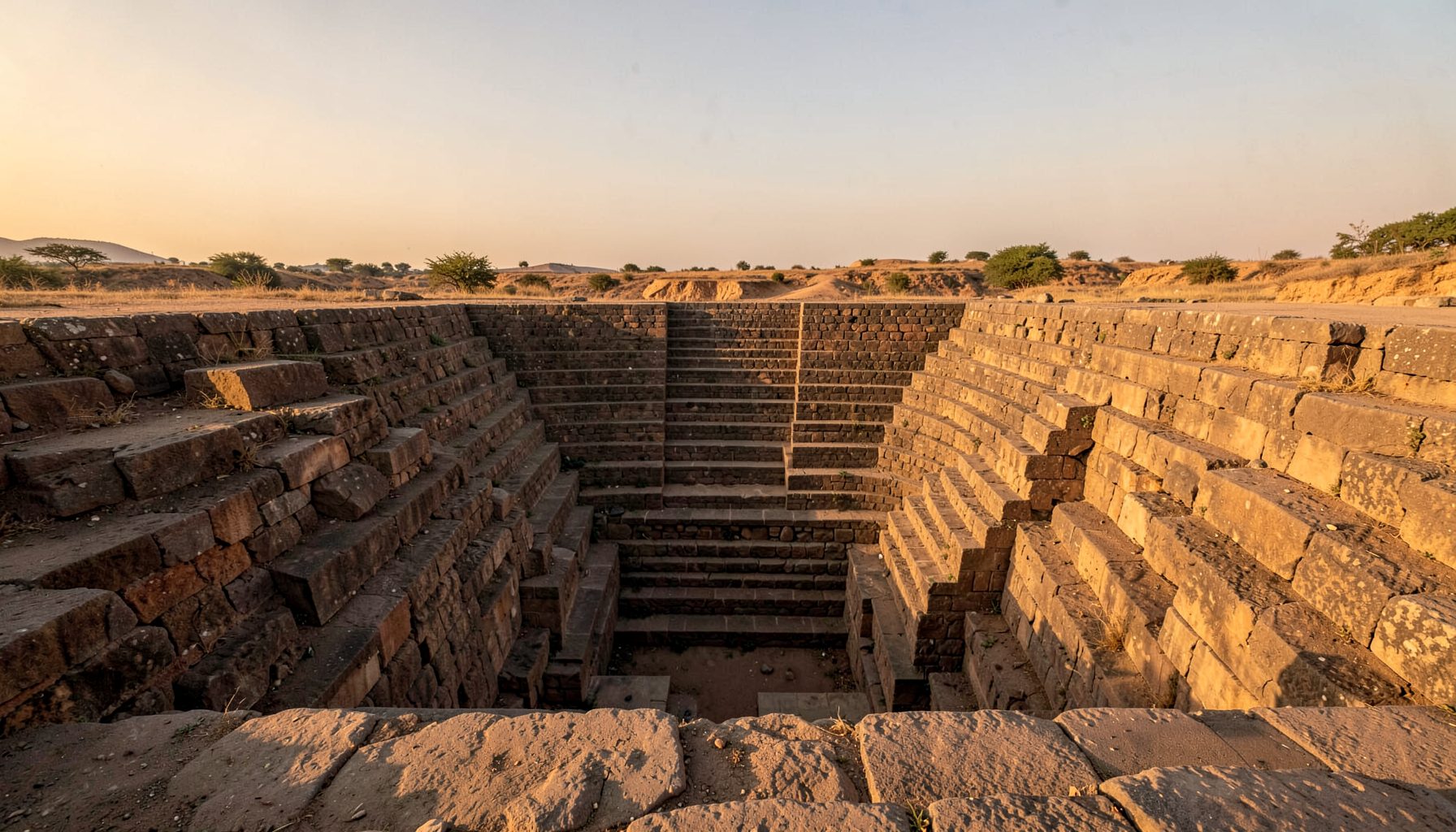
A stepwell is infrastructure and a subterranean public place. A shaft reaches groundwater, while flights, landings and corridors provide access below ground level. Tanks stored seasonal water; stepped wells also caught runoff and enabled maintenance. As temperature fell and daylight narrowed, these spaces offered coolness, conversation and a protected relationship with water.
Names change across the region. Bawri, baoli, vav, kund and barav describe pools, wells or stepwells in different languages and traditions. The Maharashtra fieldwork campaign shows the value of comparing terms carefully. Basin boundaries and local histories should guide a Banas trail rather than be erased by one national label.
Planning a responsible trail
Most of the basin is best visited from October to March, with January and February offering comfortable days and generally settled conditions for photography. The monsoon can be dramatic, but heavy rain makes access risky and briefly fills tanks. Local advice should determine whether a site is safe on the day.
Melbourne’s tram-centred travel, Sydney’s sandstone reservoirs and Canberra’s rain tanks and watering restrictions offer Australian points of reference. At Adelaide’s Central Market, many stalls accept cards while smaller sellers may prefer cash, a reminder to carry both rupees and small notes. Australian bushwalk habits also make water, sun protection and a heat plan familiar priorities.
A responsible itinerary uses local drivers, guides and village stays, asks before photographing people, and avoids working water infrastructure. Permission for drone photography should never override community etiquette or site restrictions. A temple keeper, resident or custodian may explain how a structure is used today.
Stops and themes along the route
- Kumbhalgarh and Khamnor: begin with the upper basin, where river course, temple landscape and seasonal water management establish context.
- Bhainsrorgarh and upper Banganga: trace the tributary that connects the Abhaneri monuments to the wider Banas drainage.
- Harshat Mata: study the meeting of temple, stepwell and village through its galleries and sculptural programme.
- Chand Baori: compare monumental descent with smaller community wells encountered along the route.
- Tonk and lower Banas: treat villages and less-recorded tanks as research stops, verified through local guidance.
Practical references for Australian visitors
- Timing: allow two full days for the Abhaneri corridor so changing light and conditions do not force a rushed visit.
- Transport: use reputable local transport from Jaipur or Ajmer; do not assume rural roads are accessible year-round.
- Money: keep cash for guides, fees, village shops and remote stalls; check card acceptance before leaving town.
- Customs: dress modestly near shrines, remove shoes where requested and never handle ritual objects without invitation.
- Field conduct: carry out litter, avoid blocking steps and respect groundwater, sanctums and residents’ privacy.
Reading form and function
The deepest wells are easy to classify by outline, but their details reward slower looking. A kund may be a square masonry tank, a baoli may have arched galleries, and a vav may be reached by a sloping flight. Some stand beside temples; others sit within residential lanes. Their apparent simplicity can conceal careful hydraulic and structural work.
Look for where water was controlled: inlet channels, silt traps, outlet culverts, drainage lines and access landings. Carved brackets sometimes represent deities, animals, musicians or plants. Such images made an invisible system visible, turning engineering into a civic narrative. Repetition and variation in the carving can reveal phases of repair.
Stepwells were not simply utilitarian. They supported ritual bathing, festivals and conversation, and historically gave women and other groups a significant place to gather. Present-day use may be quieter, but the space still shapes memory and neighbourhood life. Documentation should record the celebrated façade and everyday paths around it.
The Abhaneri and Banganga corridor
Harshat Mata is one of the corridor’s most complete early modern ensembles. Its temple complex and pillared stepwell are generally associated with Sawai Vishnu Singh in the sixteenth century. Carved brackets and pillars create a continuous visual field, while water and shade extend the sacred precinct into the settlement. Restoration should retain this relationship, not isolate one beautiful stair.
Chand Baori presents a different experience. Often dated to the early medieval period, though precise dating remains debated, it descends through ordered landings edged by carved pillars. Its depth makes changing air and sound as important as geometry. Visitors can read it as an engineered well, a processional route and a social chamber at once.
The pair should be seen together, alongside less monumental tanks and wells that supported nearby residents. This layered view counters a common heritage-travel habit: concentrating on the photogenic while overlooking the network that made survival possible. It also gives local guides a richer subject for discussing landscape, craft and changing water use.
Comparing regional water architecture
A southern comparison comes through Deccani elegance in stone, which traces Hyderabad’s courtly stepwell tradition. Flights, pillared terraces and garden settings can make water architecture feel palatial. In Rajasthan, impressions often come instead from geometric depth, sculptured brackets and direct contact with a village, shrine or steppe.
Comparisons are useful when they clarify rather than confuse. Deccan examples grew within a different court culture, climate and urban setting; Banas structures emerged through several regional histories. Shared elements such as shade, terraced access and carved imagery suggest common problems and design knowledge, not a single blueprint carried from place to place.
The same caution applies to terms such as “stepwell” and “baoli”. An English label may describe a shape while missing who built it, maintained it and governed its use. A trail can acknowledge these differences by keeping local names visible and linking each structure to its watershed. Regional campaigns can broaden the conversation, but they should not blur a Banas itinerary into a generic Indian checklist.
Restoration without erasure
Conservation in the Banas basin must address silt, damaged steps, altered drainage, groundwater change and uncontrolled visitation. Cleaning a tank without understanding its water paths can destroy historic fabric or worsen seepage. Repairs should use compatible materials, retain evidence of earlier phases and remain reversible where possible.
Communities are part of the conservation record. Oral histories can identify former landings, seasonal practices and lost structures that drawings cannot supply. They can reveal how a site is used for worship, meetings or everyday passage. This knowledge does not replace material conservation; it gives the work a clearer social purpose.
The account of the Quaker graveyard restoration offers a useful parallel. Its attention to a neglected Irish burial ground shows how documenting and caring for a place can preserve meaning as well as remains. A stepwell gains similar depth when conservation is framed as continuing custodianship, not the freezing of a historical moment.
Building a living archive
A strong field record combines measured drawings, positioned photographs, material notes and resident observations. Repeated photographs can reveal slow change, while sketches record dimensions and construction logic a single image may conceal. Drone views can clarify a tank’s relationship to streets, fields and waterways, provided they are lawful and do not disturb worship or homes.
Small finds deserve exact attention. A resource devoted to Neolithic precious beads illustrates how material, dimensions and findspot can turn an ornament into evidence of exchange and identity. The same principle applies here: a coin, shard, tool or carved fragment should remain in place and be reported to the appropriate authority, with its context photographed and recorded.
The final layer is shared memory. Dates, family histories, changes in water access and names for vanished wells can fill gaps in the official record. Residents, custodians and local researchers hold parts of that knowledge. Recording their accounts alongside physical evidence lets the trail remain accurate while honouring living traditions. The result is not a frozen map of monuments, but a continuing account of how people have made water, place and memory endure.
Get in Touch
Have information about a stepwell that is not yet on our map? We would be glad to document it and give you full credit. Whether it is a Barav, Kund, Vihir, or any other form of stepwell, every contribution helps preserve India's water heritage.
Call or message us with details about the location, and we will follow up.
#9372496819
Send a Message
What People Say
"The Maharashtra Stepwells campaign has brought attention to structures that were nearly forgotten. The architectural documentation and drone photography are invaluable resources for researchers and students alike."
"Collaborating with the Indian Stepwells team gave our architecture students hands-on exposure to traditional water-harvesting structures. The presentations were insightful and inspiring."
"I shared details of a stepwell near my village that was not on any map. The team visited, documented it beautifully, and credited me. It felt wonderful to contribute."