 Explore Maharashtra
The Stepwells of Bijapur: Adil Shahi Waterworks
Bijapur, now officially Vijayapura, stands in the dry northern Deccan of Karnataka, where hot seasons, uncertain rainfall and porous black soil made water storage a civic priority. Under the Adil Shahi sultans, the city developed a practical network of wells, tanks, channels and reservoirs alongside its famous domes, mosques and fortified walls. These structures were designed for daily use, ceremonial life and the survival of a growing capital.
The stepwells of Bijapur are often less elaborately ornamented than the celebrated vavs of Gujarat, yet they reveal a sophisticated understanding of climate and urban planning. Their masonry, stairways, retaining walls and surrounding gateways show how engineering was integrated into the life of the city. For visitors from Australia, where Adelaide’s dry summers and Melbourne’s water restrictions make water security a familiar subject, Bijapur offers a historic example of infrastructure treated as architecture.
A Deccan City Shaped By Water
The Adil Shahi dynasty ruled Bijapur from the late fifteenth century until the Mughal annexation of 1686. During this period, the city became a major centre of politics, trade, military power and artistic production. Its population needed reliable water for households, gardens, animals, religious institutions and visiting armies. Rainfall arrived seasonally, so the city’s survival depended on capturing and conserving it well beyond the monsoon.
The resulting hydraulic landscape included baolis and bawdis, masonry-lined wells, large reservoirs, underground channels and catchment systems. Local terminology varies across India: a baoli may refer to a stepped well, while a bawdi or barav can describe related forms of descending water architecture. In Bijapur, some structures are best understood as urban tanks with steps rather than the deep, pavilion-filled wells associated with Gujarat or Rajasthan.
This regional variation is important. A comparison with Paramara water architecture shows how different dynasties adapted similar ideas to local geology, rainfall and settlement patterns. Bijapur’s waterworks belong to a broader Indian tradition, but their scale and setting reflect the particular needs of a fortified Deccan capital.
Taj Bawdi And The Urban Tank
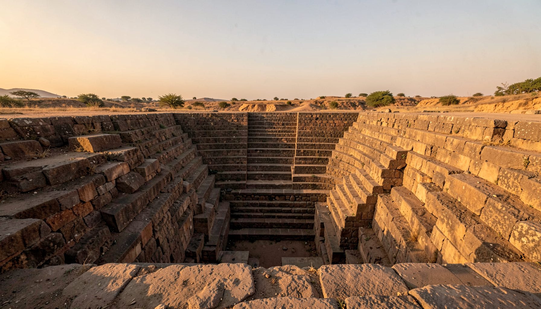
Taj Bawdi is the best-known stepped water structure in Bijapur. It was constructed in 1620 during the reign of Ibrahim Adil Shah II and commemorated Taj Sultana, the wife of his close associate Malik Sandal. The name means Taj’s well, and the monument combines a large rectangular reservoir with a substantial entrance structure on its northern side.
The broad steps allowed people to descend towards the water as its level changed through the year. The gateway, with its arched openings and upper pavilion, gave the utilitarian site a formal architectural presence. Taj Bawdi was situated near a busy part of the city, making it useful to residents while also expressing the dynasty’s ability to provide public amenities.
Its commemorative purpose adds another layer to the site. Water infrastructure could carry personal memory, dynastic prestige and religious merit at the same time. This is comparable to the way a civic structure can become a place of remembrance, as seen in Kilkenny memorial history, where a monument connects public landscape with the story of an individual. At Taj Bawdi, memory is embedded in the daily act of collecting water.
Reservoirs, Wells And Hidden Channels
Taj Bawdi was part of a wider network rather than an isolated masterpiece. Bijapur’s other historic water structures include Chand Bawdi, Bukhari Bawdi and Kamal Bawdi, along with larger reservoirs such as Begum Talab. Their forms differ, but together they indicate a layered water-supply system that served neighbourhoods, gardens, palaces and religious buildings.
Begum Talab, located south of the old city, is associated with the Adil Shahi period and is traditionally linked with the supply of water to Bijapur. Historical accounts describe channels and conduits carrying water towards the urban centre. Some routes were subterranean, protecting water from evaporation and reducing the risk of contamination. The surviving evidence is incomplete, which makes field documentation especially valuable.
A stepped well should therefore be read as one part of a catchment and distribution system. The stairs provided access, while the tank stored water; feeder channels brought rainwater or diverted supplies, and nearby streets connected the structure to households and institutions. Mapping these relationships can reveal more about the city than studying a single monument in isolation.
Architecture, Climate And Everyday Use
The construction of Bijapur’s waterworks depended on durable local masonry, carefully graded steps and thick walls capable of withstanding changing water pressure. The descending geometry also moderated access during drought, when the water surface fell far below the surrounding ground. Shaded edges and deep masonry created cooler spaces during punishing summer weather, although practical comfort was secondary to reliable supply.
The structures supported a wide range of users. Residents collected water, travellers rested nearby, animals were watered and religious communities relied on wells and tanks for ritual purposes. The social life of a bawdi could be informal and busy, with conversations, waiting, washing and exchange taking place around the same resource. Its architecture organised movement between street level and water level.
For an Australian audience, the comparison with a suburban rainwater tank is useful but limited. A tank at a Brisbane house or a water-saving garden in Adelaide is usually private or small-scale; a Bijapur bawdi was civic, monumental and shared. It made water visible as a public responsibility. Even the everyday Australian phrase “save water” gains historical depth when viewed beside a structure built to preserve every seasonal drop.
Digital presentation also affects how these places are understood. A strong heritage website can use measured drawings, drone views and close photographs to explain relationships that are difficult to see from ground level. It must compete for online attention with every kind of content, from travel advertising to a jackpot feature, making clear captions and reliable historical context essential.
Recording A Living Heritage
Many Bijapur water structures no longer perform their original role. Silt, rubbish, damaged steps, invasive vegetation and altered drainage can obscure their design. Urban expansion may sever the connection between a bawdi and its former catchment. A monument can remain visually impressive while the water system that gave it meaning disappears from public awareness.
Documentation should record more than façades. A useful survey includes location, dimensions, construction details, water levels, access routes, associated shrines, local names and oral histories. Old maps, archival photographs and satellite imagery can be compared with present conditions. Local residents may know a neglected well by a name absent from official records, or remember seasonal water use that is not visible in the masonry.
Community participation is particularly important in preservation. The principles of enabling remembrance demonstrate how public memory benefits from careful research, multiple voices and accessible interpretation. Applied to Bijapur, this means treating residents, caretakers, historians, photographers and conservation professionals as contributors to a shared record rather than presenting the city as a frozen museum.
For heritage travellers from Australia, Bijapur rewards a slower itinerary than a quick monument checklist. A visit can connect the Gol Gumbaz and Ibrahim Rauza with the less celebrated wells, reservoirs and channels that sustained them. School groups, architectural photographers and self-drive travellers moving through Karnataka can help create demand for responsible interpretation, provided visits respect local use and fragile masonry.
The Adil Shahi waterworks deserve attention because they unite engineering, memory and urban life. Their steps mark changing water levels, their gateways frame civic identity and their reservoirs preserve evidence of a society that planned around scarcity. Recording them carefully helps ensure that Bijapur’s historic landscape is understood as a functioning water city, not simply a collection of grand stone monuments.
Get in Touch
Have information about a stepwell that is not yet on our map? We would be glad to document it and give you full credit. Whether it is a Barav, Kund, Vihir, or any other form of stepwell, every contribution helps preserve India's water heritage.
Call or message us with details about the location, and we will follow up.
#9372496819
Send a Message
What People Say
"The Maharashtra Stepwells campaign has brought attention to structures that were nearly forgotten. The architectural documentation and drone photography are invaluable resources for researchers and students alike."
"Collaborating with the Indian Stepwells team gave our architecture students hands-on exposure to traditional water-harvesting structures. The presentations were insightful and inspiring."
"I shared details of a stepwell near my village that was not on any map. The team visited, documented it beautifully, and credited me. It felt wonderful to contribute."