 Explore Maharashtra
Bidar’s Water Architecture and Bahmani Ingenuity
On the northern plateau of Karnataka, Bidar preserves a remarkable record of how medieval cities found, stored and shared water. Its red laterite walls, basalt foundations, underground channels, cisterns and stepped access points reveal a practical architecture shaped by a dry climate and a sophisticated court culture. Water was never an afterthought here: it influenced the location of palaces, mosques, gardens, neighbourhoods and defensive walls.
The city reached its political importance under the Bahmani Sultanate, which made Bidar its capital in the fifteenth century. The surviving waterworks are often discussed through the famous karez network, yet the wider landscape also includes baolis, wells, tanks and stepped reservoirs. Together, these features form an interconnected heritage system rather than a collection of isolated monuments.
A Capital Built Around Water
Bidar stands on the Deccan plateau, where seasonal rainfall can be intense but unreliable. The challenge was to capture monsoon water, move it through difficult ground and retain it through the long dry season. Bahmani planners worked with the local geology, using slopes, underground channels and masonry-lined chambers to bring water closer to homes and royal compounds.
The city’s fort and urban settlements required dependable supplies for drinking, ablution, cooking, gardens and livestock. A stepwell could provide a public point of access to a declining water level, while a tank or cistern offered storage. These structures also made water visible as part of civic life: people descended, collected, rested and met within carefully built spaces.
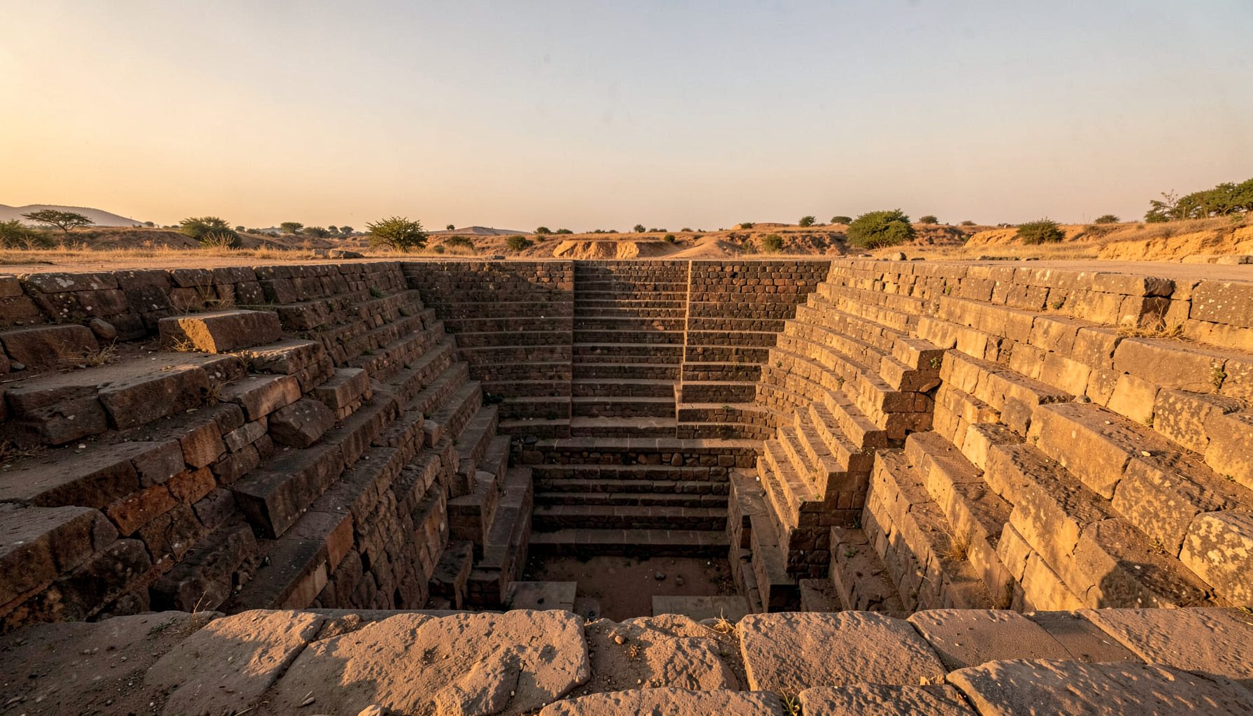
In this setting, a baoli was more than a hole in the ground. Its stairs made changing water levels accessible, and its walls offered shade as the day warmed. The vocabulary varies across India—bawdi, baoli, vav, kund and barav—but the underlying principle remains similar: architecture follows the water table.
The Karez Beneath Bidar
Bidar’s most distinctive hydraulic achievement is the karez, an underground aqueduct system associated with Persian and Central Asian engineering traditions. Vertical shafts were sunk at intervals, linked by gently sloping channels that carried groundwater towards populated areas. Workers could use the shafts during construction and later maintain the tunnels, while the covered route reduced evaporation and protected the water from contamination.
The system is commonly described as extending for many kilometres beneath and around the historic city, with branches, access shafts and collection points. Its success depended on accurate surveying. A channel that descended too sharply could erode or flood; one that lacked sufficient gradient would fail to move water. The result was a quiet piece of infrastructure hidden below the streets, but essential to the life above them.
For Australian readers, the concept has an immediate resonance. Perth’s reliance on groundwater, Adelaide’s attention to water security and the careful management of scarce supplies in regional New South Wales all show that water infrastructure can define an entire city. Bidar’s achievement belongs to a different period and technology, yet it expresses the same principle familiar in Australia: a settlement survives when its water system is understood and maintained.
Stepwells, Tanks and Fort Defences
Within Bidar’s historic precinct, water structures should be read alongside walls, gateways and palaces. Wells and reservoirs were positioned to serve people inside the fort, while protected channels helped reduce the risk of losing access during siege. Some surviving features are formal stepped wells; others are smaller access wells, masonry tanks or channels that may appear modest without archaeological context.
The stepped form allowed users to follow the water down as the level changed. Broad stairways could make a deep well safer and more practical, while landings created places to pause in shade. Stone surfaces also made cleaning and repairs easier. In a fortified capital, such details were part of resilience: a functioning water point could matter as much as a gate or tower.
This is where field documentation becomes valuable. A photograph may show a flight of worn steps, but a measured sketch can reveal its alignment, masonry phases and relationship to nearby drains. Drone imagery can show how a depression, wall and channel fit together across the wider terrain. The stepwells of Pune offer a useful comparison, because Maharashtra’s water architecture also demonstrates how local building traditions respond to geology, rainfall and settlement patterns.
Reading Bahmani Engineering Today
Bahmani engineering was neither purely monumental nor hidden in a technical sense. Its grand buildings expressed authority, while the water network provided the daily foundation for that authority. The same state that commissioned palaces and religious buildings also had to organise labour, maintenance and access to wells. Hydraulic infrastructure therefore connects political history with ordinary routines.
Bidar’s laterite and basalt landscape adds another layer to the story. Laterite can be cut into blocks and may weather distinctively, while harder basalt affects excavation and construction methods. The contrast between exposed stonework and buried channels reminds us that the city was shaped by both material conditions and imported expertise. Engineers adapted established ideas to the Deccan rather than reproducing a system without change.
Terminology can also influence conservation. A local structure may be labelled a baoli, bawli, kalyani or simply a well, depending on regional usage and the source describing it. Recording local names alongside architectural descriptions helps prevent smaller sites from disappearing under a single generic category. It also makes research more useful to residents who know a neglected water point by a name absent from official records.
Why Bidar Matters to Australian Heritage Audiences
Australian visitors often encounter heritage through practical formats: a weekend road trip, a National Trust property, a council interpretation panel or a school excursion. Bidar’s water architecture suits this way of learning because it links a visible monument to questions about climate, engineering and community use. It can be appreciated by travellers interested in Islamic architecture, photography, archaeology or sustainable design without separating those subjects from the lived history of the city.
The comparison is especially strong in places where drought and heat shape public conversation. In Melbourne, water restrictions are part of recent memory; in Perth, groundwater drawdown is an ongoing concern; across regional Victoria and inland Queensland, seasonal uncertainty affects farms and towns. Australians commonly speak of “heritage-listed” places and “water-wise” design, terms that can help frame Bidar’s stepwells as working infrastructure rather than picturesque ruins.
There is also a practical reality in the heritage market. A specialist visitor experience must compete with better-known forts and monuments, so detailed photography, clear interpretation and locally grounded guiding are important. Drone views can attract attention online, but careful documentation gives those images meaning. Exhibitions, walking tours and school resources can show how a stair, shaft or tank belongs to a larger water system.
Bidar’s surviving wells and underground channels deserve that wider reading. They record scientific knowledge, labour, religious life, urban planning and environmental adaptation in the same physical landscape. Preserving them means protecting more than stone steps: it means retaining evidence of how a Deccan capital organised survival around water.
Get in Touch
Have information about a stepwell that is not yet on our map? We would be glad to document it and give you full credit. Whether it is a Barav, Kund, Vihir, or any other form of stepwell, every contribution helps preserve India's water heritage.
Call or message us with details about the location, and we will follow up.
#9372496819
Send a Message
What People Say
"The Maharashtra Stepwells campaign has brought attention to structures that were nearly forgotten. The architectural documentation and drone photography are invaluable resources for researchers and students alike."
"Collaborating with the Indian Stepwells team gave our architecture students hands-on exposure to traditional water-harvesting structures. The presentations were insightful and inspiring."
"I shared details of a stepwell near my village that was not on any map. The team visited, documented it beautifully, and credited me. It felt wonderful to contribute."