 Explore Maharashtra
The lost stepwells of the Ghaggar River Basin
The Ghaggar River Basin holds a scattered record of water engineering built for intense summer heat and uncertain rainfall. Across Punjab, Haryana and Rajasthan, communities shaped reservoirs, channels and deep access wells that supplied water during dry months. Many survive only as altered masonry, village tanks or incomplete entries in old records.
The river is seasonal. Its upper course rises in Himachal Pradesh, crosses Punjab and Haryana, traverses Rajasthan and turns toward Pakistan, where the lower channel is commonly called the Hakra. The bed may remain dry for long stretches, and its old identification with the legendary Sarasvati remains an active historical debate rather than a settled map.
Here, “lost” means lost to reliable public knowledge. A stepwell may be buried under silt, built over by houses, reduced to a stair fragment, renamed beyond recognition, or absent from modern surveys. Some were never monumental; village wells formed the larger network sustaining farming, travel and religious life.
For Australian readers, the connection is practical and cautionary. Many Adelaide households keep rain tanks, while Melbourne and Sydney face dense development, hotter summers and intense storm runoff. The basin shows how infrastructure can become architecture and contested heritage, making careful documentation a practical lesson.
A seasonal river and an uncertain identity
Rain arrives with striking contrast. A short monsoon burst can send water racing through sandy nullahs, while the same channel may later be a dry corridor between fields. Sand and alluvium preserve traces of old flows, but present channels do not reveal where earlier streams or canals once ran.
Water shaped settlement along these routes. Farmers and pastoral communities needed dependable storage, and religious institutions often maintained tanks, wells and bathing places as charity. A stepwell could collect runoff, receive groundwater through a shaft and release water by gravity, serving several needs at once.
Today canals, highways and groundwater extraction alter drainage and village economies. The 1947 partition also divided records, communities and inherited water systems between India and Pakistan. Any survey must reconstruct a changing geography of supply, not merely locate structures.
Water held below the ground
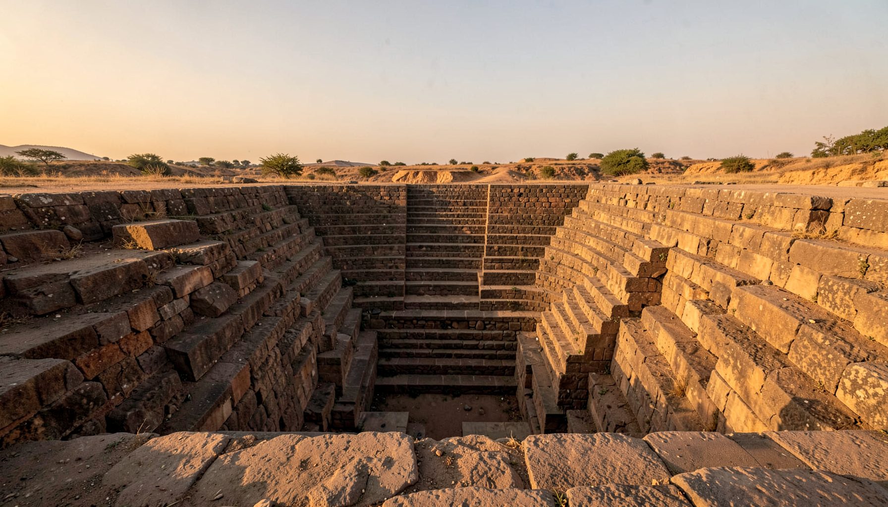
The basic stepwell is a graded descent into groundwater. Catchment channels directed runoff into a settling area, while stairs descended through cool earth toward the water table. At the deepest point, a well or shaft allowed access, and gravity moved collected water without pumps.
Labels such as bawdi, baoli, vav, kund and barav describe related forms, though local names vary. Some were capacious village cisterns; others became stepped tanks with pillared courts, arched galleries, carved niches, chabutras and pavilions. Residents’ terms often describe a place more precisely than one English category.
These structures were also climatic rooms. Deep shade moderated heat, and the journey down became social and ritual as well as practical. Surviving examples span centuries and were repeatedly repaired, so a present façade may conceal earlier phases. Architecture, hydrology and custom must be read together.
How the stepwells disappeared
Loss usually follows a sequence rather than one event. Irrigation silt can fill lower galleries; tubewells can replace the original supply; roads and expanding towns can sever access; and stone or brick may be removed for other buildings. Once a tank dries, maintenance obligation often fades.
Some sites have protection under Indian antiquities law, yet listing cannot secure a community of users. Others fall between archaeological, water-management and local-government responsibilities. A blocked drain or altered catchment may cause more damage than an obvious crack, making landscape observation as vital as architectural survey.
The Victorian discussion of symbols of broken columns offers a parallel for interpreting incomplete forms as records of interruption or deliberate change, rather than mere decay. In the basin, a stair descending into a courtyard, a row of brackets or an isolated shaft can reveal both a larger composition and the event that altered it.
Reading what remains
Finding these sites requires combined sources. Survey maps, revenue registers, archaeological schedules, gazetteers, travel accounts and family papers preserve different traces. A name recorded for a village tank may lead to a structure absent from inventories, while an old map can show a depression no longer visible.
Field evidence rewards patient observation. Stair flights, pillar bases, spillways, drain mouths and vegetation changes can expose a buried reservoir. Drone imagery can clarify the terrain without digging, while measured sketches record relationships a photograph flattens. Geophysics may help where excavation would be unjustified.
Local knowledge sharpens the record. Residents may know a tank by a shrine, grove or former household, or remember a pump, festival and path missing from maps. Interviews should retain the speaker’s terms and separate remembered history from observed fact. Consent and site sensitivity should guide publication.
Community memory and responsible tourism
Community involvement is more than collecting picturesque images. Families, temples, panchayats and local trusts may maintain tanks or control access and festivals. A plan that excludes those relationships can turn living heritage into a cleaned, closed monument separated from the people whose routines gave it meaning.
Responsible tourism can support continuity. Australia’s local heritage market includes Sydney heritage walks, Melbourne museums and galleries, regional market days and independent operators. At a stepwell, a locally guided walk that explains water management and pays local guides can be more valuable than an unsupervised photo stop.
The rural hospitality example of Casa Rural de Asturias offers a glimpse of how a rural property can support place-based interpretation, although an Indian project needs a community-defined model of ownership and benefit. Visitors should ask before crossing thresholds or photographing rituals, keep away from unstable edges and follow guidance around sacred or working spaces.
Adaptation for a hotter climate
The old engineering principles have renewed relevance. Gravity-fed collection, settling, storage and reuse can reduce demand on pumped groundwater, and developments in modern rainwater harvesting show how historic water thinking can inform present systems. Visual resemblance is not conservation, but the underlying principles are transferable.
Restoration begins with restraint. Diversion channels and silt traps may need repair before a tank is exposed, while engineers check retaining walls, stairs and foundations. Ecological surveys should look for nesting and aquatic life, and water must be tested before access. Reopening a well without these checks transfers risk to visitors.
For Australian institutions, state heritage law offers a procedural comparison, not an equivalent framework. The NSW Heritage Act 1977 and Victoria’s Heritage Act 2017 show how listing can trigger assessment and consent, while councils manage streets, drainage and public space. Indian projects must apply the relevant archaeology, water, religious and local-authority rules before choosing restoration, adaptive use or documentation.
Recommendations for responsible field documentation
A useful field record can protect a site even when repair is impossible. It should join location, condition, historical evidence and community value in a form another researcher can verify. Strong records separate what was seen, measured, heard or inferred, allowing later scholars to challenge interpretations.
The same clarity matters in an archive: image rights, sponsorship, tour terms and permissions should be disclosed beside the material. Australian consumer law reinforces that principle in promotions, while the detailed explanation of cashable bonus conditions shows how eligibility, wagering and redemption rules lose meaning when hidden. Public research archives need comparable transparency.
These practices can underpin an archive serving residents, conservators and the wider heritage community.
- Define the search area using old maps, drainage lines and settlement names before fieldwork begins.
- Triangulate archival records with oral testimony and physical evidence, keeping every source identifiable.
- Record local terms for tanks, stairs, drains and shrines, crediting knowledge holders appropriately.
- Use drones, photography and measured sketches to minimise disturbance while preserving spatial detail.
- Assess structural stability, water quality and ecology before excavation, cleaning or public access.
- Store coordinates securely and publish only what communities and site managers consider appropriate.
Taken together, this approach treats a stepwell as both engineered infrastructure and a community record. It can reveal a region’s water history while creating evidence for conservation, education and carefully managed visits, even where the safest outcome is documentation rather than reopening.
Get in Touch
Have information about a stepwell that is not yet on our map? We would be glad to document it and give you full credit. Whether it is a Barav, Kund, Vihir, or any other form of stepwell, every contribution helps preserve India's water heritage.
Call or message us with details about the location, and we will follow up.
#9372496819
Send a Message
What People Say
"The Maharashtra Stepwells campaign has brought attention to structures that were nearly forgotten. The architectural documentation and drone photography are invaluable resources for researchers and students alike."
"Collaborating with the Indian Stepwells team gave our architecture students hands-on exposure to traditional water-harvesting structures. The presentations were insightful and inspiring."
"I shared details of a stepwell near my village that was not on any map. The team visited, documented it beautifully, and credited me. It felt wonderful to contribute."