 Explore Maharashtra
The Geometry of Stepwells and the Logic of the Square
Across India, stepwells turn the practical work of collecting water into a carefully ordered architectural experience. Known as bawdis, baolis, vavs, kunds and baravs in different regions, these structures descend through stone, shadow and changing levels towards a water source below ground.
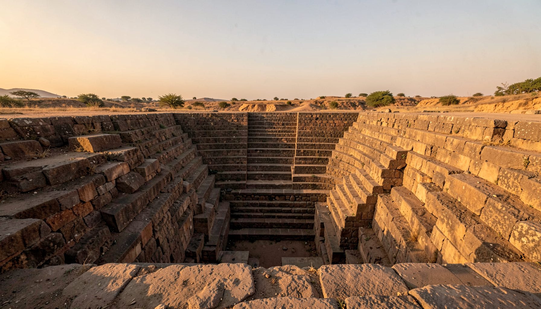
Their plans are often square or rectangular, a pattern visible from the air as clearly as it is from the lowest landing. The geometry is not simply decorative. It responds to excavation, engineering, movement, social use, climate and the need to preserve access as the water level rises and falls.
For Australian audiences familiar with dams, rainwater tanks and seasonal water restrictions, stepwells offer a different way to think about water infrastructure. They show how a utilitarian structure can become a civic space, a place of worship, a shelter from heat and a record of local craftsmanship.
Geometry begins with the water source
The central purpose of a stepwell is vertical access. A person must be able to descend safely to water that may sit several metres below ground during the dry season, then return to the surface with a filled vessel. A square or rectangular shaft gives this descent a stable, legible framework.
Straight edges are easier to set out with traditional measuring tools than complex curves. Builders could establish a central axis, mark the corners, and extend the excavation in regular stages. Each wall could be aligned with the others, allowing stone blocks, retaining courses and steps to work together as a continuous structural system.
The plan also creates a predictable relationship between the opening at the top and the reservoir below. As the water recedes, the steps remain usable. As it rises during the monsoon, lower flights disappear without disrupting the overall arrangement. Geometry becomes a practical response to seasonal fluctuation.
Why the square plan is structurally effective
A square reservoir distributes pressure in a direct and comprehensible way. The surrounding earth presses against retaining walls, while the masonry transfers loads through corners, platforms and cross-walls. Regular proportions reduce awkward unsupported spans and make repairs easier when individual stones deteriorate.
Rectangular plans offer similar advantages while allowing greater length. A long axis can organise a sequence of stairs, pavilions and landings, creating a gradual procession towards the water. In large baolis and vavs, this axis becomes an architectural narrative, moving from bright open ground into increasingly enclosed and shaded spaces.
The form also supports modular construction. Repeated bays can be added along a central line, producing a rhythm of columns, brackets and beams. This repetition is visible in many stepwells of Gujarat and Rajasthan, as well as in Maharashtra’s baravs, where the relationship between excavation and masonry is often more restrained but equally deliberate.
Rectangles, orientation and regional conditions
A rectangular stepwell can respond to the available site more effectively than a perfect square. It may fit beside a road, temple, settlement edge or natural slope, while its longer sides accommodate more steps and resting platforms. Orientation also matters: builders could use the plan to manage sunlight, shade and prevailing movement through the structure.
In hot regions, the descending route gradually changes the visitor’s experience. Surface heat gives way to cooler air, reflected light and heavier shadow. Pavilions or galleries along the long axis provide places to pause, conduct conversation or carry out ritual activity. The geometry therefore shapes comfort as much as it controls construction.
This has a useful resonance in Australia, where shaded public spaces matter in cities such as Adelaide and Perth, and where water-sensitive design is increasingly visible in parks and housing developments. A stepwell is not an underground tank in the modern engineering sense; it is a social water landscape that makes conservation visible.
Movement turns a plan into an experience
A plan drawing can make a stepwell appear static, but the structure is designed around movement. Stairs may descend from one side, two sides or several directions. Landings interrupt the vertical journey, offering changing views of the shaft, carved surfaces and sky above.
In a rectangular well, the long perspective can draw the eye towards a shrine, a pavilion or the dark surface of the reservoir. In a square kund, symmetrical flights often create a strong central focus. The repetition of treads and platforms produces visual rhythm, much like the repeated bays of a cloister or the measured spacing of a colonnade.
This is why drone photography and architectural sketches are especially valuable for heritage documentation. Aerial imagery reveals the complete geometry, while ground-level photographs record scale, texture and evidence of use. A visitor walking through the structure encounters a sequence that cannot be understood fully from either view alone.
When symmetry gives way to adaptation
Although square and rectangular plans dominate, stepwell architecture is not governed by a single formula. Some structures include irregular additions, angled approaches, circular elements or surrounding courtyards. Repairs, changes in water flow and later religious use can alter an original layout.
The apparent symmetry may also conceal practical adjustments. One staircase can be steeper because of the site, a wall can thicken where the ground is unstable, or a pavilion can be shifted to preserve an older shrine. Local materials and building traditions influence the final result as much as abstract geometry.
Maharashtra provides many examples where the surviving form is less monumental than the celebrated multi-storey vavs of western India. Some baravs are partly buried, overgrown or incorporated into village life. The forgotten baravs survey demonstrates how mapping can recover patterns that are difficult to see from a single photograph.
Reading a stepwell in the field
Fieldwork begins by treating geometry as evidence rather than assuming that every measurement reflects the original design. Researchers record the overall footprint, the width of stairways, the number of landings, the position of water and the relationship with nearby buildings. They also note later concrete work, rubbish, vegetation and signs of active community use.
For an Australian heritage audience, this approach connects with the work of local historians, National Trust groups and council heritage teams. A small water structure in a regional town may receive little attention until measured, photographed and placed within a wider landscape story. The same principle applies to an undocumented barav near a village road.
A careful record can include a hand-drawn plan, compass orientation, elevation changes, material notes and photographs taken at different times of day. It is useful to compare these with satellite imagery, old maps and oral accounts. An independent cultural publication such as The Star of Zion illustrates how specialist storytelling can give overlooked places a wider public setting.
A practical guide to observing form
When examining a stepwell, the most useful questions connect geometry with use. The aim is to understand why the structure takes its shape, not simply to label it square, rectangular or irregular.
- Identify the main axis and locate the reservoir in relation to the entrance.
- Count stair flights, landings, platforms and repeated structural bays.
- Look for changes in masonry that may indicate repairs, additions or altered water levels.
- Record shade, airflow and the direction of sunlight at different points in the descent.
- Compare the structure with nearby temples, roads, fields, settlements or drainage channels.
- Photograph both the complete footprint and the details that explain how people moved through it.
Patterns are often easiest to recognise when several sites are compared. A small village barav may share the same proportional logic as a larger monument, even when its carvings are modest and its walls have been repaired. Documentation turns these relationships into a visible body of knowledge.
Interpretation should also remain careful and grounded. Online material about games of chance, such as scratch game strategies, may use pattern and probability in a very different context; architectural documentation, by contrast, tests visual impressions against measurements, materials and historical evidence. This distinction matters when photographs circulate widely without reliable site information.
Stepwells endure in memory because their geometry makes water legible. The square and rectangle organise labour, shade, movement and storage into a form that can be measured, entered and remembered. For researchers, photographers and communities, that clarity offers a strong starting point for protecting structures whose quiet presence still shapes India’s cultural landscape.
Where a local site remains undocumented, observations can be shared through the heritage contact page, helping connect community knowledge with future surveys, photographs and preservation work.
Get in Touch
Have information about a stepwell that is not yet on our map? We would be glad to document it and give you full credit. Whether it is a Barav, Kund, Vihir, or any other form of stepwell, every contribution helps preserve India's water heritage.
Call or message us with details about the location, and we will follow up.
#9372496819
Send a Message
What People Say
"The Maharashtra Stepwells campaign has brought attention to structures that were nearly forgotten. The architectural documentation and drone photography are invaluable resources for researchers and students alike."
"Collaborating with the Indian Stepwells team gave our architecture students hands-on exposure to traditional water-harvesting structures. The presentations were insightful and inspiring."
"I shared details of a stepwell near my village that was not on any map. The team visited, documented it beautifully, and credited me. It felt wonderful to contribute."