 Explore Maharashtra
Stepwells and the Monsoon Cycle in Indian Water Architecture
Across India, rain has always been more than a weather event. The arrival, movement and retreat of the monsoon shaped settlement patterns, agricultural routines, religious practices and architectural ingenuity. Stepwells were designed around this seasonal rhythm, collecting water when rainfall was abundant and preserving it through the long, dry months that followed.
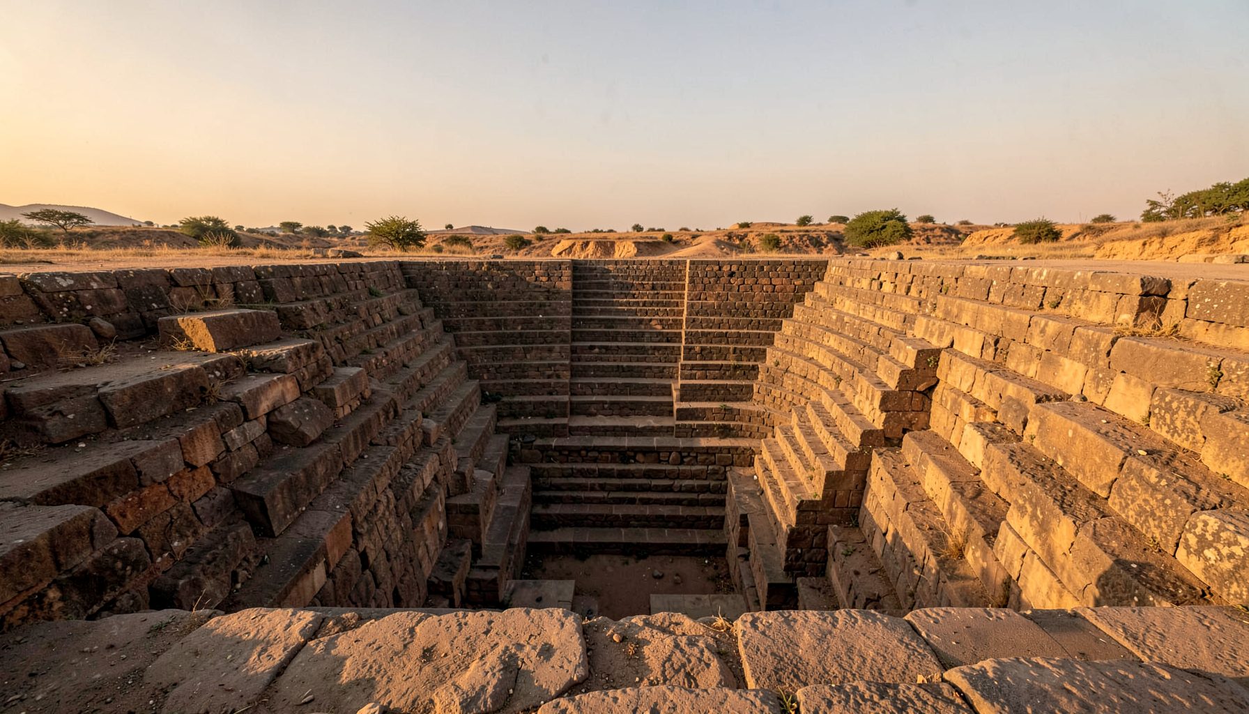
A stepwell could be called a bawdi, baoli, vav, kund or barav, depending on its region and language. Each name reflects a related tradition of descending into the earth to reach stored water. These structures were practical reservoirs, but their stairways, pavilions, columns and carved walls also made water access a civic and cultural experience.
The pattern remains especially visible in Maharashtra, where local geography produces a varied relationship between heavy monsoon rainfall and seasonal scarcity. A well may fill rapidly during intense storms, then become a gradually shrinking reserve for nearby farms, villages, travellers and animals. Its architecture records this annual change in water level.
The work documented by Indian Stepwells brings together field research, original photography, architectural sketches and drone imagery. Such records help explain how these places functioned, while inviting communities to identify undocumented wells that may otherwise disappear from public memory.
Reading Rain As Architecture
Stepwells make sense when viewed as water-management systems rather than isolated monuments. Their builders considered the slope of the land, the direction of runoff, the depth of the water table and the likely length of the dry season. Steps allowed people to follow the water downwards as the reservoir emptied, extending access well beyond the first weeks after the rains.
The monsoon cycle created several distinct phases. Before the rains, a stepwell might be dusty, shaded and quiet, with its lowest chambers still holding a small reserve. During the wet season, channels and catchment areas directed stormwater into the structure. After the monsoon, the stored water became increasingly valuable, and the lower flights of stairs became the main route to the supply.
This seasonal movement explains why many stepwells contain terraces, landings and resting places. These features helped people carry water safely at different depths. They also regulated movement, allowing animals, workers and visitors to share the space without turning the descent into a dangerous scramble.
The Monsoon Calendar In Stone
Rainfall in much of India is concentrated into a short period, so the capacity to store water determines how a community copes with the rest of the year. A well that captures runoff from a broad compound or hillside can transform a brief downpour into months of usable supply. The deep, enclosed form reduces evaporation compared with an exposed pond.
The water level also influenced the atmosphere of a stepwell. Upper galleries could remain hot and bright while lower chambers offered cool shade. As the water descended, the architecture appeared to change character: thresholds that had once been close to the surface became distant, and decorative details emerged from shadow or disappeared below it.
This relationship between water and visibility is one reason stepwells are valuable photographic subjects. A visit made after the monsoon may reveal a different building from one seen at the end of summer. For heritage photographers, the changing light, depth and reflection provide evidence of seasonal use rather than simply producing attractive images.
From Catchment To Underground Reservoir
A stepwell usually worked as part of a wider hydrological network. Paved surfaces, courtyards, embankments, drains and nearby fields directed rainwater towards the reservoir. Openings were positioned to admit water while limiting the entry of silt, leaves and other debris. In some settings, the surrounding ground helped filter water as it moved downwards.
Underground construction also moderated temperature. Cool air collected in the deeper chambers, providing relief for people travelling through hot regions. This made the structure useful beyond its role as a water source. It could serve as a meeting place, a resting station, a site for ritual activity or a shaded route between settlements.
The carved surfaces were part of this experience. Floral motifs, guardians, geometric patterns and niches gave visual order to a descent that might otherwise feel purely functional. The relationship between ornament and utility is explored in niche decoration, where small architectural details reveal how stepwell walls were designed to hold meaning as well as shade.
Maharashtra's Regional Variations
Maharashtra contains several kinds of stepwell and water tank, reflecting differences in geology, rainfall and settlement history. In the Deccan plateau, basalt formations influence excavation and groundwater movement. Some structures are compact and austere, while others have carefully built stairs, retaining walls and shrines. Their condition can vary dramatically, even between sites located only a short distance apart.
The monsoon is especially significant in areas where a few months of rainfall must support agriculture and domestic needs for the remainder of the year. A neglected drain or blocked inlet can reduce a well’s effectiveness, while erosion can damage steps and destabilise surrounding masonry. Documentation therefore needs to record the landscape around the structure, not simply its visible façade.
Modern development has altered many catchment areas. Roads, concrete compounds and construction debris can interrupt traditional water paths. In cities such as Pune and Nashik, pressure from expanding suburbs changes the relationship between historic wells and the communities that once maintained them. Field photography and measured drawings can preserve evidence of this transformation.
Water, Community And Seasonal Use
Stepwells were social infrastructure. People met while collecting water, exchanged local news and coordinated everyday work around the times when a well was most accessible. Women often carried much of the responsibility for household water collection, making the structure a place where labour, community knowledge and seasonal observation came together.
The condition of a stepwell can therefore reveal changes in local life. A site may remain architecturally impressive but lose its function when piped water arrives, traditional paths disappear or maintenance responsibilities become unclear. In other cases, villagers continue using the water during shortages, even when the structure is absent from official heritage registers.
There are useful comparisons with Australia, where rainwater tanks are familiar features of rural properties and suburban homes. Melbourne households may track rainfall and tank levels through a dry summer, while residents of Adelaide and regional South Australia often pay close attention to water efficiency. These systems differ in scale, yet they share the principle that rainfall must be captured when available and managed carefully afterwards.
Seasonal infrastructure can also shape movement across landscapes. The history of the coffin road in County Mayo shows how routes become tied to local climate, terrain and communal necessity. Stepwells similarly connect water, travel and memory, creating places where environmental conditions influence the organisation of daily life.
Field Evidence That Reveals Seasonal Change
A consistent documentation method makes it easier to compare stepwells across districts and across seasons. Photographs should show both architectural details and the surrounding catchment, while sketches can clarify levels, alignments and access routes that are difficult to read from a single image. Drone views may reveal the larger drainage pattern, especially where later development has obscured it from ground level.
Local testimony is equally important. Residents may know when a well fills, which inlet carries the strongest flow, whether water is still used for livestock or which repairs were made by earlier generations. Their knowledge can explain features that are not immediately obvious in masonry, including seasonal paths and former channels.
Useful field observations include:
- Water level recorded at different points in the year
- Inlets, overflow channels and visible silt deposits
- Shade, ventilation and access at each landing
- Current use by residents, farmers, animals or visitors
- Damage caused by vegetation, traffic, dumping or construction
These records support public education and future conservation decisions. They can also help researchers distinguish a structure built for permanent groundwater access from one designed primarily to capture monsoon runoff.
Lessons For Australian Water Thinking
Australia’s water landscape offers its own examples of seasonal adaptation. Brisbane households are familiar with intense summer storms and stormwater surges, while much of the country experiences long intervals between reliable rainfall. In Sydney, public discussion of dams, restrictions and catchment protection regularly connects urban life with distant water sources. Stepwells provide a historic example of making that connection visible within the built environment.
The Australian heritage market also shows growing interest in places that combine architecture, landscape and cultural history. Visitors may encounter heritage sites through regional walking trails, architecture programs, photography exhibitions or weekend markets near old town centres. A restored water structure can become part of this local economy when interpretation respects its community meaning rather than treating it as a decorative backdrop.
Digital publishing expands that audience, although it also competes with fast-moving online entertainment. A heritage website may sit alongside very different forms of web content, including guides to high-volatility slots, yet careful images and field notes can still encourage slower attention to place. The value lies in giving viewers enough context to understand why a structure matters.
For Australian readers, the central lesson is practical: water storage is cultural infrastructure as well as engineering. A tank, dam, wetland or historic reservoir carries stories about rainfall, labour and decisions made under pressure. India’s stepwells make those stories tangible by allowing visitors to descend through the changing levels of a seasonal water reserve.
Get in Touch
Have information about a stepwell that is not yet on our map? We would be glad to document it and give you full credit. Whether it is a Barav, Kund, Vihir, or any other form of stepwell, every contribution helps preserve India's water heritage.
Call or message us with details about the location, and we will follow up.
#9372496819
Send a Message
What People Say
"The Maharashtra Stepwells campaign has brought attention to structures that were nearly forgotten. The architectural documentation and drone photography are invaluable resources for researchers and students alike."
"Collaborating with the Indian Stepwells team gave our architecture students hands-on exposure to traditional water-harvesting structures. The presentations were insightful and inspiring."
"I shared details of a stepwell near my village that was not on any map. The team visited, documented it beautifully, and credited me. It felt wonderful to contribute."