 Explore Maharashtra
Stepwells and local calendars in agricultural water cycles
Stepwells and local calendars form a practical archive of water, work and weather. In western India, the arrival of rain, the condition of a well and the date for sowing shaped one another. A reservoir’s level could signal when irrigation became practical, while a village almanac organised labour around it. These records reveal how communities turned seasonal uncertainty into shared routines.
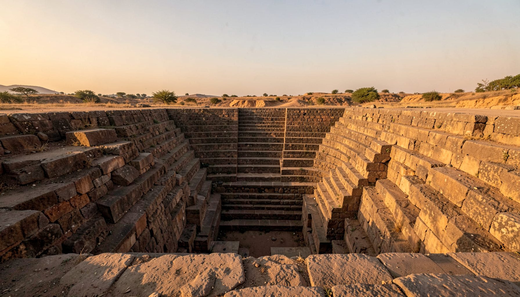
Stepwells were descending public spaces where people reached groundwater through stairs, shafts and terraces. Their regional names include bawdi, baoli, vav, kund and barav. Some stored monsoon runoff; others promoted percolation into aquifers. Many also served people, animals and nearby plots, linking civic water supply with cultivation.
The architecture is easier to understand when it is read beside living agricultural traditions. Indian Stepwells combines original photography, sketches, drone imagery and field research, with a current emphasis on Maharashtra. Its approach treats each structure as both a water system and a record of the community that maintained it.
For Australian readers, Indian stepwells offer a distant but useful comparison with irrigation districts, drought planning and seasonal work. The comparison has limits: monsoon rainfall, village custom and pre-colonial water law differed from Australian entitlements and centralised allocation. The strongest connection lies in how water levels become signals embedded in calendars, decisions and local memory.
Rain arrives, but the calendar decides
The useful starting point is timing. A strong monsoon can fill a stepwell quickly, yet the same rain may arrive too late for a crop already sown or too early for harvesting. A farmer therefore watched several indicators together: overnight rain, the colour of the catchment, the water line on masonry and the date named in a local calendar.
Stepwell levels changed through a cycle rather than sitting at one “full” mark. Water rose after rain, settled as sediment cleared the pores, and fell through evaporation, withdrawals and dry weather. The visible record could include damp stains above the current surface, worn stair edges, water-loving plants and deposits of silt or salt. Each feature records duration as well as depth.
Crop calendars made those levels actionable. Terms such as kharif and rabi are useful starting points, but district calendars and village almanacs determined actual work. Chaitra, Shravan and Bhadrapada might organise expectations across March to September, while sowing and harvesting festivals fixed the labour rhythm. Irrigation, grazing, repair work and religious observance could therefore converge on the same week.
Reading a changing water line
Field observation begins with the built edge. Surveyors photograph each accessible landing, note stains and leakage, and compare the deepest visible marks with local accounts. A staircase may be submerged for months, emerge during a dry month and carry different sediment after a storm. Such changes turn a static monument into a seasonal instrument.
Local calendars add what masonry cannot show. Elders, farmers, well keepers and pastoral families may remember when water first reached a step, which crop needed support, or which festival followed a failed monsoon. Those memories can be plotted against rainfall records, but they should be recorded with names and meanings intact rather than forced into a single national calendar.
Reading place through repeated movement also reveals public memory. A Glasnevin Cemetery walk links paths, named individuals and political memory through guided observation. The parallel here is methodological: patient walking and attention can expose relationships that an isolated object or official date conceals.
Water architecture across Saurashtra
Saurashtra contains forms suited to different settlements and water regimes. Broad flights allow easy access as a tank recedes; deep shafts protect a smaller reserve; narrow passages and overhead galleries temper heat and movement. Some complexes collect roof runoff, while others connect to channels, fields or tanks through a wider catchment network.
A regional perspective appears in the Saurashtra field survey, which examines stepwells as cultural and hydrological structures rather than isolated ruins. Comparing villages makes visible how geology, rainfall, settlement and agricultural demand shape design. A well that appears modest beside a reservoir may have supplied several households and animals over many dry months.
Maharashtra’s stepwells add another layer, from compact village bawdis to larger, stepped complexes. In areas where rabi cultivation matters, a dependable well can support winter crops after the monsoon has ended. Its value may therefore peak late in the agricultural year, when stored water is scarce but demand for irrigation, washing and livestock remains high.
An Australian comparison without false equivalence
Along the Murray–Darling Basin, water is commonly discussed through entitlements, allocations and a farm’s share of a regulated volume. In some southern Basin districts, temporary trades can move allocation between irrigators, while low reservoir readings or announced drought conditions tighten the planning horizon. Stepwells were not equivalent corporate assets, but both systems make timing part of the product.
The comparison becomes tangible around Mildura and the Sunraysia district, where grape, citrus and other horticultural farms rely on Murray water under intense summer heat. In the Campaspe and Goulburn areas around Rochester and Shepparton, irrigators plan permanent plantings and annual crops against allocations, soil moisture and rainfall. Salinity, evaporation and pump costs can matter as much as the headline volume.
Australian farm language makes this practical: “water year”, “allocation”, “entitlement” and “dry spell” recur in field days and irrigation offices. A short dry spell is monitored through probes and rainfall totals; drought signals deeper shortages. On the Adelaide Plains, market gardens supplying Adelaide must also compete with household demand, adding an urban market pressure quite different from a self-contained village well.
Seasonal knowledge is not only a European farming calendar. Across parts of the Murray–Darling region, Aboriginal seasonal calendars track flowering, animal movement, grass growth and changing weather through place-specific signs. These systems are not interchangeable with an Indian panchang, and their authority rests with knowledge holders. Both traditions nevertheless show that a calendar can encode obligations as well as months.
Field signals for water, season and stewardship
A stepwell becomes more informative when its architecture, water history and agricultural calendar are documented as one record. The most useful evidence sits at transitions: where a worn step meets damp masonry, where a spillway enters a field, or where a local crop name coincides with a remembered water level.
- Damp courses and mineral stains marking former water levels
- Worn stair landings showing repeated access at different depths
- Silt, moss, salt crust and plants indicating wetting and exposure
- Channels, spillways and silt traps linking the well to its catchment
These observations gain meaning through chronology. One high level may reflect a wet monsoon; a persistent lower line may reflect changed maintenance or heavier use. The distinction matters because an apparent rise in groundwater is not always the same as an improvement in agricultural reliability.
- Local names and dates for sowing, harvesting, grazing and watering
- Festival or almanac markers linked to the agricultural year
- Accounts of who maintained channels, steps and communal access
- Comparisons between water levels, rainfall and changes in crop choice
Local knowledge can also bring overlooked structures into the record. Researchers can contribute photographs, sketches, drone imagery and field notes through document an undocumented stepwell. At the same time, exhibitions and public interpretation can keep stepwells visible as civic infrastructure rather than picturesque remnants, with communities retaining a central role in deciding how their history is shared.
Get in Touch
Have information about a stepwell that is not yet on our map? We would be glad to document it and give you full credit. Whether it is a Barav, Kund, Vihir, or any other form of stepwell, every contribution helps preserve India's water heritage.
Call or message us with details about the location, and we will follow up.
#9372496819
Send a Message
What People Say
"The Maharashtra Stepwells campaign has brought attention to structures that were nearly forgotten. The architectural documentation and drone photography are invaluable resources for researchers and students alike."
"Collaborating with the Indian Stepwells team gave our architecture students hands-on exposure to traditional water-harvesting structures. The presentations were insightful and inspiring."
"I shared details of a stepwell near my village that was not on any map. The team visited, documented it beautifully, and credited me. It felt wonderful to contribute."