 Explore Maharashtra
Stepwells of Saurashtra: water, culture and landscape
The stepwells of Saurashtra form a dispersed heritage of water, architecture and collective memory. A cultural and hydrological survey must look beyond celebrated monuments to include neighbourhood vavs, temple kunds, baolis, bavdis and baravs: some maintained, many altered, and others surviving only in memory or scattered stonework. Across limestone, sandstone and granite zones, they record how communities managed monsoon floods, seasonal drought, groundwater salinity and reliable access to water.
Surveying them requires equal attention to names, use and absence. A shaft may look dry beside a modern borewell yet remain central to a festival, household routine or local account of ancestors. The strongest field study therefore combines archival research, original photography, measured drawings and conversations with residents, treating each structure as infrastructure, vernacular architecture and a record of place.
Water shaped the settlement pattern
Most of Saurashtra has sharply differentiated wet and dry seasons. Rainfall concentrates in the monsoon, while rivers such as the Machhu, Bhesan and Dhadar, as well as smaller streams, lose much of their flow before reaching the coast. Wells, tanks and stepwells allowed settlements to bridge that seasonal gap and draw on groundwater renewed by rain.
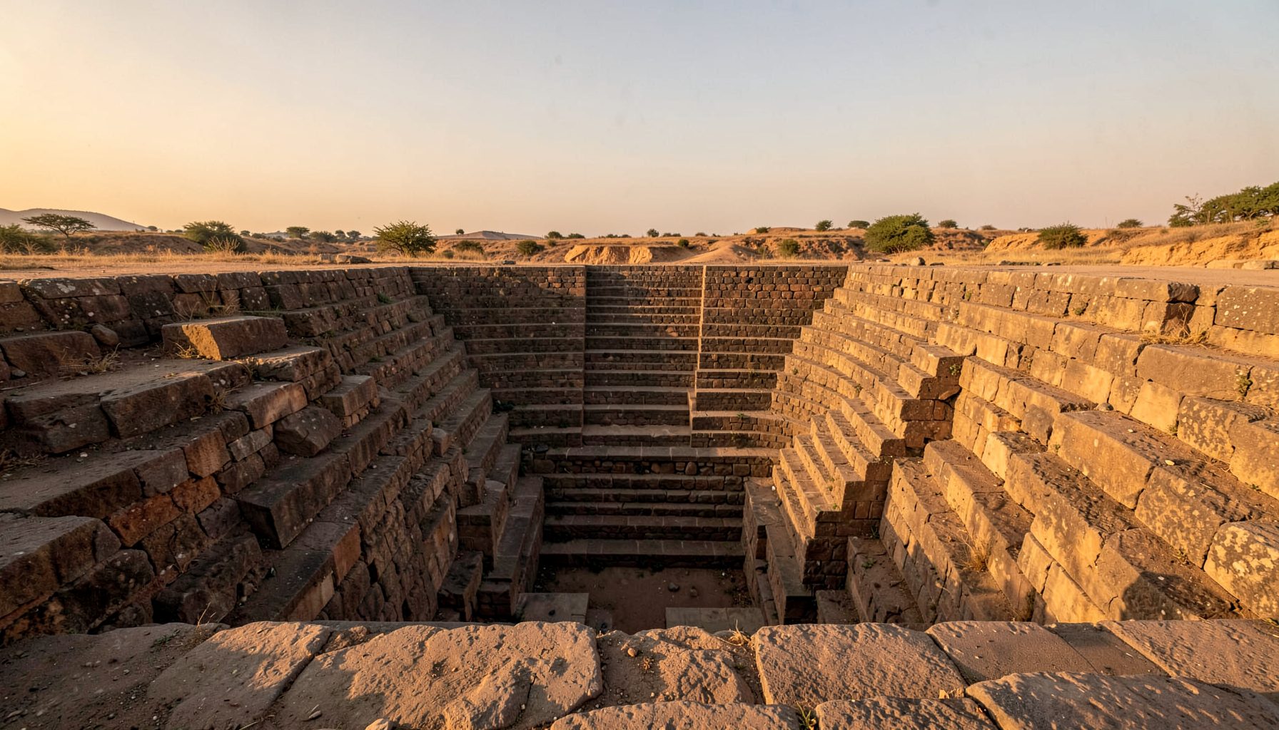
Stepwells are especially legible as water architecture because their depth is exposed through descending flights. Stairs connect street level to a shaft, water court or reservoir; gates, platforms, columns and covered passages make access controlled and sometimes social as well as hydraulic. The form turns a local water source into a shared civic space.
At town scale, these sites often lie on routes between bazaars, temples and residential quarters. Their siting reflects geology, flood risk and walking distance, while upkeep has depended on shared labour, ritual calendars and rules of access. Coastal salinity, silting and falling water tables now complicate both their operation and preservation.
A regional vocabulary of wells
Local terminology changes with distance and language. Vav usually identifies a descending stepwell; kund often denotes a tank or reservoir; baoli, bavdi and barav occur across neighbouring traditions. These labels are not rigid categories. A structure may combine a well shaft, stepped bathing ghat, catch basin and temple court within one hydraulic system.
Three broad forms recur. Shaft wells drop vertically through rock to one or more water-bearing levels. Terraced vavs descend in stages toward broad basins, and gallery or haveli wells enclose the well within roofed rooms and corridors. Some have tanks with little or no built descent, revealing that the essential element may be storage and controlled access rather than monumental stairwork.
Design responds to local material. Dressed limestone permits precise carving and long flights; sandstone and conglomerate encourage compact forms; fractured rock demands thicker retaining walls. Chutes, inlets, spillways and silt traps reveal the wider water cycle. A dry basin can still disclose its original hydrology through outlets, mineral bands, damp stains and sediment.
Carved stories in stone
Architectural carvings turn these utilitarian structures into cultural records. Floral motifs, geometric borders, footprints, deity images and representations of water spirits often connect the source with purity, fertility and protection. Placement matters: a carving in a public corridor or beside a water court could mark devotion, memory or ritual decorum.
Seasonal imagery offers a comparative way to read such programmes. The seasonal stone carvings at St Patrick’s Cathedral in Dublin show how artists can encode weather cycles and the year within masonry. The comparison is methodological rather than functional: a cathedral and a stepwell belong to different institutions, but both can turn observed environmental change into cultural memory.
Oral traditions add another layer. Well names may preserve a saint, ruler, donor, trade route or former hamlet. Festivals, processions and daily queues can reveal a community’s relation to water long after architectural details are lost. Researchers should record competing memories, transliteration choices and silences rather than choosing the tidiest narrative.
Locating the surviving structures
Finding a Saurashtrian stepwell begins with place names rather than a list of famous monuments. Survey sheets, revenue records, old newspapers, temple registers, family papers and historical photographs can reveal tanks later filled or built over. A name recorded as a well may conceal a vav, and an old street alignment may preserve a vanished water route.
Field verification must distinguish a true stepwell from an ordinary shaft, cistern, reservoir or bathing tank. Repeated photography from fixed viewpoints, measured sketches and GPS coordinates make small alterations visible. Repeated visits also distinguish a seasonal pool from a functioning hydraulic system and reveal groundwater, sediment, vegetation and repair patterns.
Permissions, safe access and local sensitivities shape the survey. Open shafts, unstable steps, heat and monsoon downpours require care, while drone imagery should be used only where lawful, safe and appropriate. Newly located or vulnerable sites may need controlled locations so documentation does not accelerate neglect or disturbance. Community-led records can place unrecorded wells in a broader historical network without exposing sensitive locations.
Photography, mapping and material evidence
Photography serves three purposes in this heritage: record, comparison and communication. Close views capture tool marks, carving styles, mineral crusts and repairs. Wider frames show relationships to streets, farms, shrines and tanks, while measured or aerial views clarify terraces and drainage. Each image needs a date, direction, scale and brief caption so it remains evidence rather than atmosphere.
The documentation model of the Indian Stepwells archive demonstrates the value of combining original photography, architectural sketches, drone imagery and field research. Its present emphasis on Maharashtra offers a useful technical comparison, while Saurashtra still requires its own inventories of local forms, water sources and community histories.
Seasonal repeat photography is especially valuable. The same shaft can shift from pooled water to exposed steps, then to damp sediment or vegetation. Paired with water-level notes and interviews, this sequence turns architecture into a hydrological record. It also reveals maintenance responses and changing access in a way that a single visit can miss.
Reading Saurashtra from Australia
For Australian readers, Saurashtra offers a familiar problem in unfamiliar form. Like the rain tanks beside many Adelaide homes, a stepwell stores seasonal water close to where it is needed, but its depth, geology and ritual use create different pressures. Melbourne’s dry summers and periodic water restrictions, together with Sydney’s experience of intense storm runoff followed by dry spells, likewise show that urban water security depends on more than rainfall.
Local markets provide an everyday parallel. At Melbourne’s Queen Victoria Market and Adelaide’s Central Market, reusable bottles and keep-cup habits have become part of Australian café and shopping customs. These habits reduce disposable waste, yet they remain practical responses rather than historic water systems. Saurashtrian vavs show the deeper architecture that can arise when a community designs around water over generations.
Heritage participation is another shared connection. Melbourne’s volunteer walking tours and Sydney’s coastal bush-care groups combine observation, public education and stewardship, much as a stepwell survey can connect residents with an overlooked civic structure. Comparisons with Australian tanks or community practices should remain careful, since their climates, materials, histories and cultural meanings differ from those of Saurashtra.
A field survey checklist
A useful survey records what is visible, what is inferred and what local knowledge can add. The two field streams below should be cross-checked rather than separated, with photographs and measurements supporting every interpretation.
The hydrological pass should capture:
- Water presence, depth, seasonal flow, salinity, contamination risk and access, noting when each observation was made.
- Shaft depth, stair runs, outlets, overflows, silt deposits, retaining walls and visible repair phases.
- Links to roof runoff, streams, wells, tanks, pumps and groundwater, distinguishing observed connections from local interpretations.
- Damp surfaces, salt crusts, algae, sediment and vegetation as indicators of changing water conditions.
The cultural pass should document:
- Names in local scripts and Roman transliteration, preserving spelling variants and changes in neighbourhood identity.
- Carvings, shrines, houses, paths, festivals and everyday water practices as parts of one cultural landscape.
- Oral histories, maintenance customs, present-day use, ownership, access rules and conservation concerns with consent.
- Whether an undocumented site can be published openly or should have its coordinates withheld temporarily.
Together, these observations produce a durable record of water supply, design and social meaning. Secured photographs, sketches and local accounts can reveal patterns across Saurashtra while keeping individual communities at the centre of interpretation and stewardship.
Get in Touch
Have information about a stepwell that is not yet on our map? We would be glad to document it and give you full credit. Whether it is a Barav, Kund, Vihir, or any other form of stepwell, every contribution helps preserve India's water heritage.
Call or message us with details about the location, and we will follow up.
#9372496819
Send a Message
What People Say
"The Maharashtra Stepwells campaign has brought attention to structures that were nearly forgotten. The architectural documentation and drone photography are invaluable resources for researchers and students alike."
"Collaborating with the Indian Stepwells team gave our architecture students hands-on exposure to traditional water-harvesting structures. The presentations were insightful and inspiring."
"I shared details of a stepwell near my village that was not on any map. The team visited, documented it beautifully, and credited me. It felt wonderful to contribute."