 Explore Maharashtra
Stepwells, colonialism and British engineering studies
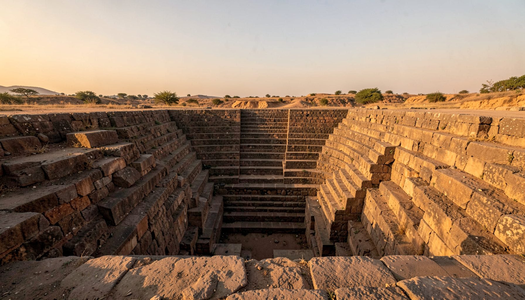
Stepwells are water-conserving structures with deep local histories, and many long predate British rule. During the colonial period, however, engineers studying India’s bawdis, baolis, vavs, kunds and baravas produced surveys, maps, photographs and administrative reports that reshaped how these places were understood. Their records can preserve rare technical detail while reflecting the priorities of imperial government.
Those records belong to a second history layered over older systems of hydraulic engineering. Read alongside oral testimony, inscriptions and present-day use, they reveal what colonial observers noticed, measured or misunderstood. They are especially valuable to researchers mapping Maharashtra’s stepwell heritage, provided the reports are treated as evidence about British administration as well as about the structures themselves.
Engineering knowledge under imperial administration
Many Deccan bawdis were already centuries old when British officers and public works engineers worked across the Bombay Presidency. They encountered water systems serving towns, forts, gardens, livestock and religious communities, often maintained through local rules about drawing water, cleaning and repair. Imperial researchers inherited this practical knowledge, then recast it through civil engineering, sanitation, revenue mapping and archaeology.
Their studies were driven by immediate needs: locating reliable water, maintaining cantonments, improving roads and judging whether old tanks deserved repair. Accounts range from careful condition reports to sweeping claims about “native” practice. Recent Bidar research offers a useful precolonial counterpart, showing how Bahmani engineering can be understood on its own terms rather than as a colonial achievement.
What colonial surveys measured
Colonial surveyors commonly recorded depth, horizontal span, stair geometry, stone type and the height of surrounding walls. Notes on silt, evaporation, groundwater, rainfall and the distance to a river allowed an older water structure to be assessed as infrastructure. Such details may now support conservation, especially where masonry has shifted or access routes have changed.
A measured plan, however, is also an act of selection. Standard drawings can flatten an irregular, multilevel place into a neat profile, while maps may replace local names with administrative labels. Comparing several plans can reveal disagreements between engineers and show which features survived repeated redrawing.
Water supply and public health
Stepwells and older tanks formed part of the water supply around British cantonments and civil stations. Engineers compared their reliability, maintenance costs and yields with bore wells, reservoirs and piped systems. A structure that had served generations could be praised as economical in one report and dismissed as obsolete in another when administrative priorities changed.
Public-health concerns added another filter. Water in open masonry tanks could attract complaints about surface debris, animal use or contamination after heavy rain, encouraging engineers to favour protected wells and pipes. Such judgements could obscure local practices for keeping steps and pools clean. Health campaigns also shifted responsibility for water from local custodians and village users towards municipal authorities, changing both access and accountability.
Photography and the colonial gaze
Photography made stepwell architecture available to officials and audiences far beyond each site. Photographs could record ornament, construction details and changing conditions, yet they often isolated a structure as a picturesque spectacle or disappearing relic. An empty frame could hide queues, water carriers, repair work, festivals and the social rules governing access.
A comparison with Irish heritage landscapes is instructive because architectural remains in Ireland likewise sit within layers of settlement, landholding and later decline. In both settings, the camera tends to privilege what looks stable while ordinary maintenance and contested histories disappear from view. Present-day photography, drone imagery and measured sketches can counter that imbalance when linked to local testimony.
Reading silences in the archive
The archive is often thick with descriptions of stone and thin with details of human work. People who drew water, swept steps, repaired walls, guided visitors or managed seasonal access were frequently recorded by occupation, caste, class or gender rather than by name. Their absence from a report is not proof that their knowledge was unimportant, but it affects how confidently the structure can be interpreted.
A modern rural electrification case study from Spain shows a comparable documentary risk: technical reports can describe communities through voltage, installed capacity and distance from a road. Repeated labels can make a distributed local network appear uniform and newly planned. Colonial stepwell files need the same scrutiny, alongside regional gazetteers, Persian or Marathi records, inscriptions and oral histories.
Field methods for comparative stepwell research
A careful reading separates the structure, the report and the period of use. Useful evidence from plans and reports includes:
- Record dimensions, gradients, materials and repair phases, then compare those details with surviving masonry.
- Note water sources, seasonal yield and nearby settlements that explain why the stepwell was built.
- Identify whether a drawing represents a field survey, an idealised design or a later reconstruction.
- Compare official repair proposals with evidence that local communities continued using the structure.
The same review must extend beyond official papers. Community-led documentation can reveal relationships that a technical file omitted:
- Capture local names, maintenance customs, access rules and memories associated with each water structure.
- Observe seasonal use, water conditions and connections to wells, ponds, canals, shrines, markets and paths.
- Distinguish present-day additions from earlier fabric before assessing suitable conservation treatment.
- Record consent, dates and locations for photography, sketching and any drone survey.
These methods suit Australian heritage customs such as community walking tours, photographic surveys and local historical archives. Readers in Sydney may recognise the interpretive layers within sandstone colonial precincts; Melbourne’s laneways reveal infrastructure hidden behind lively façades, while Queen Victoria Market connects architecture with food exchange and everyday city life. Adelaide’s hot, dry summers give historic water storage and groundwater management immediate local resonance.
Preservation through shared documentation
The Indian Stepwells project sets out its documentation approach, combining original photography, architectural sketches, drone imagery and field research with a current emphasis on Maharashtra. It also invites residents to identify undocumented stepwells, a route that can connect isolated structures to a regional water network without replacing local knowledge with online claims.
For a site such as a Deccan bawdi, the most resilient record joins construction evidence to biographies of use: quarry origins, tool marks, water rights, maintenance cycles, changing groundwater and later interventions. British plans and photographs remain valuable as one historical layer, yet they should not become the starting point for every origin story. A stepwell is protected when precolonial design, local stewardship and colonial observation remain visible together, allowing it to function as a record of environment, labour and community rather than a relic reserved for experts.
Get in Touch
Have information about a stepwell that is not yet on our map? We would be glad to document it and give you full credit. Whether it is a Barav, Kund, Vihir, or any other form of stepwell, every contribution helps preserve India's water heritage.
Call or message us with details about the location, and we will follow up.
#9372496819
Send a Message
What People Say
"The Maharashtra Stepwells campaign has brought attention to structures that were nearly forgotten. The architectural documentation and drone photography are invaluable resources for researchers and students alike."
"Collaborating with the Indian Stepwells team gave our architecture students hands-on exposure to traditional water-harvesting structures. The presentations were insightful and inspiring."
"I shared details of a stepwell near my village that was not on any map. The team visited, documented it beautifully, and credited me. It felt wonderful to contribute."