 Explore Maharashtra
Reconstructing a stepwell from drone imagery
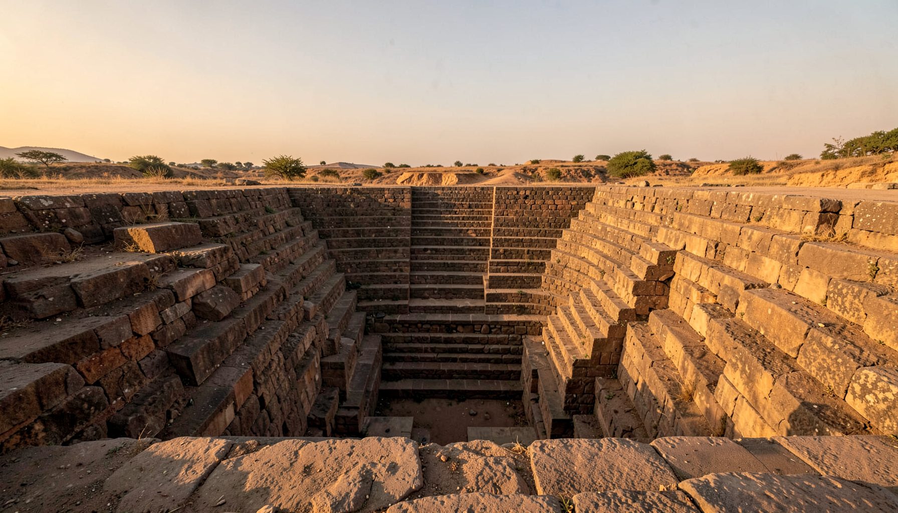
A stepwell is a structure that changes dramatically when seen from above. At ground level, a visitor may notice a weathered entrance, a broken stair flight or a line of carved stone. Drone photography reveals the larger order: terraces, axial alignments, retaining walls, platforms, wells and traces of buildings that have disappeared. Combined with ground photographs and measured drawings, this aerial record can support a convincing digital reconstruction.
Three-dimensional modelling does not mean inventing a perfect monument. It means creating a transparent interpretation of what the evidence can support. A missing pavilion might be represented as a simplified volume, while a surviving landing can be modelled with individual stones and accurate dimensions. The distinction between observed, inferred and speculative elements is essential for heritage work.
For an Australian audience, this approach has practical relevance beyond India. Dry landscapes, water scarcity and remote heritage sites are familiar realities from inland New South Wales to South Australia and Western Australia. A digital model can help people understand how an historic water system worked without requiring every visitor to travel to a rural location.
Why drone imagery matters for stepwell research
A drone survey captures the geometry of a stepwell in a way that conventional photography cannot. Overlapping images taken from multiple heights allow photogrammetry software to calculate common points and build a dense point cloud. That cloud can then become a mesh, an orthophoto, a contour map or a measured base for architectural drawing.
The most valuable results often come from combining viewpoints. Vertical images clarify the plan, oblique images show the depth of steps and walls, and low-level photographs record masonry joints, tool marks and surface damage. Shadow patterns can expose shallow depressions, blocked stairways and changes in wall height. A drone is therefore a measuring instrument as much as a camera.
Flight planning needs care. Strong sun can create harsh contrast, while loose dust and intense heat may affect equipment and batteries. In Australia, operators also need to consider CASA rules, no-fly zones, nearby roads and the permissions of landowners or councils. Similar preparation is necessary in Maharashtra, where a remote-looking site may still sit close to homes, farms, temples or active roads.
Building a reliable image record
A reconstruction begins before the first flight. Researchers should establish the site boundary, identify safe take-off points and photograph fixed reference markers. Ground control points, measured with survey equipment or a reliable GNSS receiver, give the model a spatial framework. Without them, a photogrammetric model may look detailed while remaining inaccurate in scale or orientation.
Image overlap is equally important. A regular flight grid can capture the main plan, followed by circular or angled passes around deep walls. Narrow staircases and shaded chambers often need separate close-range photography. Every part of the structure should appear in several images, with enough visual texture for the software to match one photograph to another.
A field notebook adds information that photographs cannot preserve. It can record stone types, repairs, vegetation, water staining, blocked passages and local names. Interviews with nearby residents may identify seasonal water behaviour or buried features, although oral evidence should be documented separately from measured evidence. The Indian Stepwells research project demonstrates the value of combining photography, field observation and public heritage education.
Turning photographs into a 3D model
Photogrammetry software first aligns the images by locating shared visual features. It then generates a sparse point cloud, followed by a denser cloud and a polygon mesh. The mesh can be textured with the original photographs, producing a visually rich model of the surviving structure. Scale and orientation are corrected using ground control points and known measurements taken on site.
The raw output is rarely ready for publication. Vegetation, people, birds, moving shadows and passing vehicles can produce errors. Water surfaces are especially difficult because they reflect light rather than presenting stable texture. Broken masonry may also be smoothed into a misleading continuous wall. Cleaning the point cloud and checking key dimensions against field measurements are necessary parts of the process.
A good workflow keeps several versions of the model. One high-resolution archive file preserves research detail, while lighter versions can be used in a browser, exhibition screen or virtual-reality viewer. The texture should be stored separately where possible, and the project should retain original photographs, processing settings, coordinate information and dates. These records make later corrections possible when new evidence emerges.
Interpreting missing architecture
The central challenge is deciding what should be reconstructed. Surviving geometry provides the strongest evidence: a stair width may indicate the dimensions of a missing flight, while sockets in a wall may suggest the former position of beams. Repeated proportions in nearby structures can provide useful comparisons, but they should not automatically be treated as proof.
A digital model can communicate uncertainty through colour, opacity or surface treatment. Existing stone may appear with a photographic texture, inferred elements with a neutral material, and hypothetical additions with a translucent or lightly shaded finish. A simple legend helps visitors understand the difference. This is more honest than presenting every reconstructed column and cornice as certain.
Regional comparisons can sharpen interpretation. The Bijapur waterworks study offers a useful reminder that stepwells formed part of broader systems of storage, access and civic planning. A model should therefore show relationships between the well, stairs, retaining structures, catchment areas and surrounding settlement rather than treating the monument as an isolated decorative object.
Presenting the model to Australian audiences
A digital reconstruction becomes more useful when it answers practical questions. Where did rainwater enter? How did people reach the water as the level fell? Which surfaces were public, restricted or ceremonial? A short animated sequence can show changing water levels across a dry season, while a cutaway view can reveal underground chambers and drainage paths.
Australian visitors often respond to clear links with local experience. A stepwell can be compared with the water tanks, dams and seasonal creeks familiar in regional communities, without suggesting that the structures are identical. Interpretation may also refer to water-sensitive design in Melbourne, drought planning around the Murray–Darling Basin or the logistical realities of visiting remote heritage places. Plain language works well: “stairs to the water” is often more effective than unexplained technical terminology.
Online presentation also requires attention to how people browse. A model should load on an ordinary phone, offer captions and avoid relying on fast movement or sound. Interactive heritage platforms can learn from other visual web experiences, including the clear navigation used by an online gaming platform, while keeping the purpose, tone and evidence standards appropriate to cultural documentation.
From research model to public heritage resource
The finished reconstruction can support exhibitions, school lessons, conservation planning and community discussion. A museum screen might allow visitors to compare the current ruins with several reconstruction phases. An architect could use the model to study drainage and structural risk, while a teacher could explain geometry, water management and trade routes through one site.
Public communication needs careful attribution. Photographers, surveyors, local informants, historians and technical specialists should be credited, and permissions for drone imagery should be recorded. Sensitive information may need limits, particularly where a site has religious significance, private ownership or fragile remains. Sharing every coordinate or access route is not always responsible heritage practice.
The model can also connect documented sites with broader conversations about water and climate. Search interest in Australia often moves between heritage travel, practical water knowledge and digital entertainment, which is why clearly separated editorial context matters; even a page discussing Australian casino offers should not blur commercial content with archaeological interpretation. For a heritage website, the strongest result is a carefully sourced visual record that helps people value structures before they disappear.
A drone-based reconstruction is ultimately a layered argument made visible. The aerial survey supplies spatial evidence, fieldwork supplies texture and context, historical comparison supplies interpretation, and the 3D model brings those strands together. When uncertainty remains visible, digital technology can deepen trust rather than replace it.
Get in Touch
Have information about a stepwell that is not yet on our map? We would be glad to document it and give you full credit. Whether it is a Barav, Kund, Vihir, or any other form of stepwell, every contribution helps preserve India's water heritage.
Call or message us with details about the location, and we will follow up.
#9372496819
Send a Message
What People Say
"The Maharashtra Stepwells campaign has brought attention to structures that were nearly forgotten. The architectural documentation and drone photography are invaluable resources for researchers and students alike."
"Collaborating with the Indian Stepwells team gave our architecture students hands-on exposure to traditional water-harvesting structures. The presentations were insightful and inspiring."
"I shared details of a stepwell near my village that was not on any map. The team visited, documented it beautifully, and credited me. It felt wonderful to contribute."