 Explore Maharashtra
Mapping the Stepwells of Nagpur Through Citizen Science
Citizen science is reshaping how communities document fragile cultural landscapes, and few structures are as quietly disappearing as the stepwells of central India. The Indian Stepwells project has turned its lens toward Nagpur, a city better known for its oranges than its water architecture, inviting volunteers from around the world to help catalogue every surviving baoli, kund, and barav in the region. By combining traditional fieldwork with open digital mapping, the initiative aims to create a permanent record of structures that have sustained villages for centuries but now sit forgotten behind housing colonies or beneath encroaching vegetation.
For an Australian reader, the appeal is immediate. Whether you are based in Sydney, Adelaide, or a regional town in Western Australia, the project offers a way to engage with Indian heritage without needing to book a flight to Maharashtra. Many participants are members of the Indian diaspora, retirees with a background in architecture, or university students looking for meaningful remote projects. The work relies on shared photographs, oral histories from Nagpur residents, and location data that can be uploaded from a smartphone. It is heritage work that fits neatly into a weekend arvo, and it contributes to a growing international archive.
The Landscape of Nagpur's Hidden Water Heritage
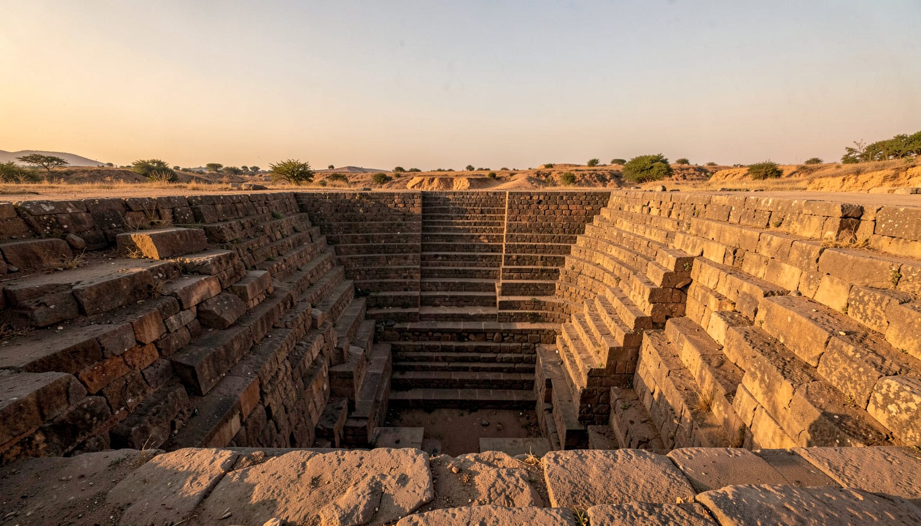
Nagpur sits in the Vidarbha region, a geological bowl of volcanic soil and seasonal rivers that made water harvesting a matter of survival rather than aesthetics. The stepwells here are different from the ornate stepwells of Gujarat or the towering vavs of Rajasthan. They tend to be deeper, narrower, and integrated into the bedrock, with long flights of steps descending to a water table that fluctuates dramatically with the monsoon. Local terms vary from village to village, with some structures called bawdis, others referred to as kunds, and a few simply known by the name of the family who commissioned them three hundred years ago.
Many of these wells were abandoned after piped municipal water reached the districts in the 1970s. Without regular maintenance, silt accumulates, masonry crumbles, and trees take root in the steps. The urgency of documentation is not abstract; it is a race against encroachment, illegal dumping, and the slow grinding of neglect. A survey conducted in early 2024 found that out of 142 known wells in the greater Nagpur district, only 38 were in a condition that could be described as stable. The rest ranged from partially collapsed to completely buried.
Why Nagpur? A Geographer's Perspective
Central India has long been treated as a transit zone between the more celebrated stepwell regions of the west and the temple tank traditions of the south. Nagpur challenges that narrative because it sits on a historical fault line of architectural influence. The Maratha period structures here share engineering features with the stepwells of Madhya Pradesh, particularly the intricate corbelled brackets and the inverted temple tower motifs that mark the entrance pavilions. Yet the Nagpur examples also incorporate local basalt techniques that make them visually distinct.
The region's dry deciduous climate also offers a testing ground for citizen science methods. Unlike the heavily visited stepwells of Adalaj or Abhaneri, the Nagpur structures are dispersed across a hundred kilometre radius, often down unmarked village roads. This dispersion is exactly what makes crowdsourced mapping valuable. No single researcher could cover the ground in a single field season, but a coordinated network of local volunteers, each covering their own tehsil, can build a comprehensive picture in a matter of months.
Tools and Techniques for Field Documentation
The Indian Stepwells project relies on a deliberately low-tech, high-trust methodology. Volunteers are asked to photograph a structure from four fixed angles, record the GPS coordinates with a smartphone, and submit a short audio note describing the current state of the well. A simple datasheet prompts for basic measurements, visible damage, and any inscriptions that might identify the builder or the date of construction. The team in Nagpur reviews every submission, cross-referencing it with revenue records and historical gazetteers before publishing it to the main map.
Drone photography is used selectively, primarily for larger structures where a ground-level view cannot capture the full extent of the damage. International heritage documentation projects have demonstrated that consistent photographic standards are more valuable than expensive equipment. A methodology developed in a completely different context, such as the crowdsourced heritage surveys seen on community-driven platforms, shows how local knowledge combined with open data can produce reliable historical records when the criteria for contribution are clear and the review process is rigorous.
Building a Volunteer Network Across Continents
The most surprising outcome of the project so far has been the willingness of Australian volunteers to participate. There is a large Marathi-speaking community in Melbourne and Sydney, and many second-generation members have a personal connection to villages in the Vidarbha region. Online orientation sessions are held twice a month, typically timed to suit both Indian mornings and Australian evenings. Participants are paired with field volunteers in Nagpur, creating a direct link between the diaspora researcher and the local contributor who can verify access permissions and arrange site visits.
University partnerships have also been crucial. The University of Melbourne's School of Geography has integrated the project into its fieldwork methods course, and similar expressions of interest have come from the Australian National University in Canberra. Students earn academic credit while contributing to a real heritage database, and many continue as volunteers after graduation. The network now includes architects, hydrologists, historians, and amateur photographers, all working from their laptops in Adelaide or Brisbane while feeding data into a shared archive.
From Data Collection to Digital Mapping
Once verified, the data is published to an open-source map that anyone can access. The mapping interface uses OpenStreetMap layers combined with custom icons that distinguish between stepwell types, condition grades, and historical periods. Volunteers can download the raw dataset, which includes over 1,200 photographs and 300 audio recordings, and use it for their own research or teaching. The platform is built to be slow, accessible, and screen-reader friendly, prioritising the experience of users on basic smartphones in rural India over the aesthetic preferences of Western web design.
The digital workflow avoids the temptation to chase every passing online trend. The project team deliberately stays away from short-form video platforms and viral content formats, focusing instead on stable, citable archives. The contrast with the fleeting nature of general internet content is stark. A page listing trending music on YouTube may pull millions of views for a week before vanishing into algorithmic obscurity, but a heritage record needs to remain accessible for decades. This focus on longevity over virality is a conscious choice that shapes every technical decision.
Challenges of Crowdsourced Heritage Work
Crowdsourcing is not without its pitfalls. The most persistent issue is data inconsistency, particularly around measurements. Some volunteers include the full depth of the well, others only measure the visible steps. Standardising these metrics requires constant training and a clear feedback loop. The project has addressed this by creating short video tutorials in Marathi, Hindi, and English, and by appointing regional coordinators who can resolve disputes in the field rather than through email chains.
Funding remains the other major challenge. The project runs on a combination of small grants, personal contributions from the founders, and in-kind support from local printing shops in Nagpur. There is no permanent staff, and the website is maintained by volunteers in their spare time. Sponsorship from Australian heritage foundations, particularly those with an interest in Indo-Pacific cultural exchange, could help sustain the work for another decade, but securing that funding requires demonstrating impact in measurable terms.
Pathways to Preservation and Public Awareness
Documentation is only the first step. The longer term goal is to use the map to advocate for the physical protection of the most endangered sites. The project team works closely with the Nagpur Municipal Corporation and the Maharashtra State Archaeology Department, providing them with the condition reports and location data they need to prioritise restoration. Three wells have already been listed for emergency conservation work after being flagged through the citizen science network.
Public exhibitions are planned for early 2026, with shows scheduled in Nagpur, Pune, and potentially Sydney. A book featuring the best photography from the project is also in preparation. For anyone interested in learning more about the broader mission and the people behind the work, the About page on the Indian Stepwells site outlines the history of the initiative and the ways that new volunteers can get involved. Whether you are a heritage professional, a curious traveller, or simply someone who cares about water architecture, there is a role to play in keeping these structures alive for the next generation.
Field-Ready Guidance for New Volunteers
- Download the project datasheet and familiarise yourself with the four standard photographic angles before your first site visit.
- Carry a printed copy of the local revenue map for the village you intend to survey, as it often marks wells that no longer appear on digital maps.
- Always inform a local contact before entering private property, and never descend into a well that shows signs of recent collapse.
- Record audio notes in a quiet environment, and speak in the local dialect if possible, as the audio is used by researchers who may not speak the language of the original surveyor.
- Submit your data within 48 hours of the site visit, while the details are still fresh, and be prepared to answer follow-up questions from the verification team.
- Share your findings with local schools or community groups in Nagpur if you are visiting in person, as oral history is a vital part of the documentation process.
- Treat every stepwell with respect, removing any litter you find and avoiding the removal of stones, carvings, or other historical fragments.
Get in Touch
Have information about a stepwell that is not yet on our map? We would be glad to document it and give you full credit. Whether it is a Barav, Kund, Vihir, or any other form of stepwell, every contribution helps preserve India's water heritage.
Call or message us with details about the location, and we will follow up.
#9372496819
Send a Message
What People Say
"The Maharashtra Stepwells campaign has brought attention to structures that were nearly forgotten. The architectural documentation and drone photography are invaluable resources for researchers and students alike."
"Collaborating with the Indian Stepwells team gave our architecture students hands-on exposure to traditional water-harvesting structures. The presentations were insightful and inspiring."
"I shared details of a stepwell near my village that was not on any map. The team visited, documented it beautifully, and credited me. It felt wonderful to contribute."