 Explore Maharashtra
Water, work and India's stepwell trade networks
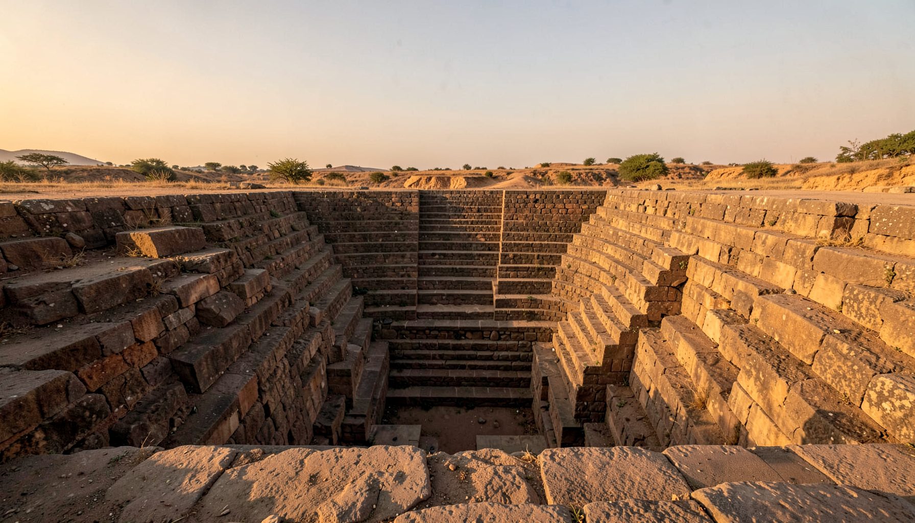
Stepwells facilitated long-distance trade routes by turning seasonal water into dependable support for merchants, pilgrims, animals and settlements. Across arid and semi-arid India, descending wells collected monsoon runoff, protected it from evaporation and contamination, and made water available where journeys paused. Their importance was logistical as well as architectural: reliable water allowed traffic to continue and helped market towns endure.
Local vocabulary reflects geography and function. Vavs, baolis, bawdis, kunds and baravs describe related water works with different shapes and uses. Some hold water in open tanks; others descend underground; a few combine a well with halls, shrines or bathing spaces. Travellers therefore encountered locally adapted provisions for water, rest and ritual rather than one uniform structure.
The strongest links with commerce appear when wells are read alongside roads, caravanserais, markets, temples and settlements rather than as isolated monuments. Their effects could be direct, through service to travellers, or indirect, by sustaining towns where contracts were made. Historical evidence is uneven, so geographic pattern offers a credible framework without treating every well as a trade station.
Water at the edge of the road
Monsoon rainfall was concentrated in a short season, while trade journeys crossed months of dry country. A stepwell gathered runoff and stored it below ground, where soil and masonry reduced heat and evaporation. Descending stairs allowed water to be drawn with less lifting. The result was a dependable reserve at the edge of inhabited terrain.
Reserves clustered along corridors between inland markets and ports through Gujarat, Rajasthan, Madhya Pradesh and Maharashtra. Around Patan, Ahmedabad, Bundi and Chittorgarh, water points served caravans and residents; in the Deccan, wells linked farming districts, pilgrimage centres and coastal trade. Roads shifted as chains of stops, so dependable water reduced detours and animal failure.
Vavs, baolis, bawdis and kunds
An illustrated stepwell glossary distinguishes tanks, wells, stepped reservoirs and underground chambers while showing how builders adapted each form. The differences affected use. Stairs, platforms and passages determined whether people approached water from above, through a court or within a shaded architectural complex.
A kund might be a temple tank, while a barav could denote a deep well or related reservoir. In Maharashtra, kinar and barav traditions could differ from the monumental vav of western India. Builders responded to geology, groundwater and patronage, producing varied forms rather than one design copied between centres.
Built form also shaped movement and meeting. Platforms offered places to wait for a caravan or exchange news; shrines drew worshippers; upper rooms served attendants. Access could vary by season, gender and status, yet these remained social landscapes where travel, trade and ritual overlapped.
Patrons, ports and the cost of thirst
Water works required money, labour and authority. Queens, rulers and wealthy townspeople presented some as acts of piety or public benefit. The fifteenth-century Adalaj vav near Ahmedabad and eleventh-century Rani ki Vav at Patan show how prestigious building could secure a community's place within a wider urban and sacred order. Endowments supported daily water while announcing donor status.
Trade connected these inland communities to coastal emporia and ports. Salt from Rajasthan, cotton and cloth from Gujarat, metalware, grain, indigo and horses travelled through networks of pack and draught animals, while spices and textiles moved between ports and inland markets. A well did not carry those goods itself; it sustained the people, animals and stopping places needed to keep the chain moving.
That distinction keeps the evidence in proportion. Water points reduced the physical cost of thirst, but profits came from linked services: fodder, lodging, guides, guards, packers, translators, money changers and market stalls. A dependable halt could turn a seasonal crossing into a recurring commercial route and make a settlement attractive to itinerant traders.
Pilgrimage, information and everyday exchange
Sacred journeys enlarged the commercial network. Pilgrims needed water at intervals, especially around temple towns, river crossings and desert passages. Wells near places of worship also attracted donors, servants and residents, so regular foot traffic reinforced markets serving festivals and daily needs. Routes carrying reputation, ritual objects and pilgrims could carry commercial information in the same direction.
At a busy water point, people encountered languages, prices and news from distant regions. Brokers learned which caravan was approaching; families exchanged goods; guides learned which roads remained passable after rain. These exchanges could be more valuable than a water purchase. The well became a fixed reference in a mobile world, allowing information to circulate through remembered stops.
Trade history should also include people whose names rarely appear in court chronicles. Women managing household water, porters loading vessels, fodder sellers, masons and shrine attendants sustained the routes. Restrictions on access shaped who could use particular spaces and when, yet communities repeatedly adapted shared water works to social need. Long-distance commerce rested on ordinary maintenance and negotiation as well as monumental architecture.
Lessons from Australian travel country
Australians have their own culture of long-distance movement. In central and northern Australia, articulated trucks are commonly called “road trains”, while roadside fuel-and-food stops are often known as roadhouses. Alice Springs functions as a services hub for routes across the Northern Territory, while Broken Hill and Mildura connect mining, agricultural and freight districts. The comparison is useful because distance creates similar demand for reliable stopping places, though the climates and vehicles differ.
Water shapes inland life much as it did around an Indian vav. Communities such as Alice Springs, Coober Pedy and Broken Hill rely on bores, reservoirs and managed town supplies, while summer heat limits water use and outdoor activity. These systems require monitoring, rules and maintenance. Australian usage of “outback” for remote country also captures the need to plan journeys around scarce services rather than assume every route offers a nearby town.
Heritage work follows a mixed economy of museums, volunteer historical societies, local councils and state heritage programs. Grants, public visits and regional tourism support the care of roads, mines, railways and water infrastructure. An independent publication of Irish travel routes offers a useful comparison: landscapes are experienced through connections rather than isolated landmarks. For Australian heritage audiences, Indian stepwells broaden the familiar story of trade, adaptation and survival in dry landscapes.
Documenting routes before they vanish
Maharashtra's baravs, kinars and smaller kunds are often embedded in village fabric, where tanks, temple precincts and wells can share catchment and patronage. A tank may appear on maps as a water source yet remain absent from records of historic travel. Remote imagery can reveal its setting, while close inspection records masonry, access and signs of current use.
Fieldwork organised through Indian Stepwells combines original photography, architectural sketches, drone views and site research. This layered record can show relationships missed by a single image: a well beside an old road, a landing near a market, or a reservoir connected to settlement drainage. Such details help researchers test whether geography supports a proposed trade connection.
Local knowledge is equally important. Residents may know an undocumented structure by a name absent from official records, or remember when it last held water. Communities can also explain changing groundwater, contamination, access rights and maintenance. Surveys become stronger when they record those living relationships while respecting the people who have cared for the place.
A preservation agenda for route landscapes
Protecting a well in isolation can preserve masonry while losing the reason it mattered. Conservation should include the associated route, catchment, settlement and community memory. Each site requires assessment of water supply, structural condition, cultural use and public access. Interpretation can then explain how architecture sustained movement rather than presenting a mysterious monument detached from commerce.
A practical agenda for documentation and preservation includes:
- Map wells alongside historic roads, caravan camps, markets, ports, temples and settlements.
- Record local names, seasonal water use, maintenance practices and oral histories with informed consent.
- Include nearby communities and present-day custodians in research, monitoring and decisions.
- Assess structural stability and water quality before tourism or infrastructure changes the setting.
- Interpret routes through merchants, porters, pilgrims, animals, workers and elite patrons alike.
- Combine archival research, photography and drone survey with conservation grants and local stewardship.
This approach treats each water work as part of a living system. It preserves the architecture while documenting the exchanges, labour and environmental knowledge that made long-distance travel possible, giving future researchers a fuller account of how networks formed.
Get in Touch
Have information about a stepwell that is not yet on our map? We would be glad to document it and give you full credit. Whether it is a Barav, Kund, Vihir, or any other form of stepwell, every contribution helps preserve India's water heritage.
Call or message us with details about the location, and we will follow up.
#9372496819
Send a Message
What People Say
"The Maharashtra Stepwells campaign has brought attention to structures that were nearly forgotten. The architectural documentation and drone photography are invaluable resources for researchers and students alike."
"Collaborating with the Indian Stepwells team gave our architecture students hands-on exposure to traditional water-harvesting structures. The presentations were insightful and inspiring."
"I shared details of a stepwell near my village that was not on any map. The team visited, documented it beautifully, and credited me. It felt wonderful to contribute."