 Explore Maharashtra
Why Stepwells Were Built Outside City Walls
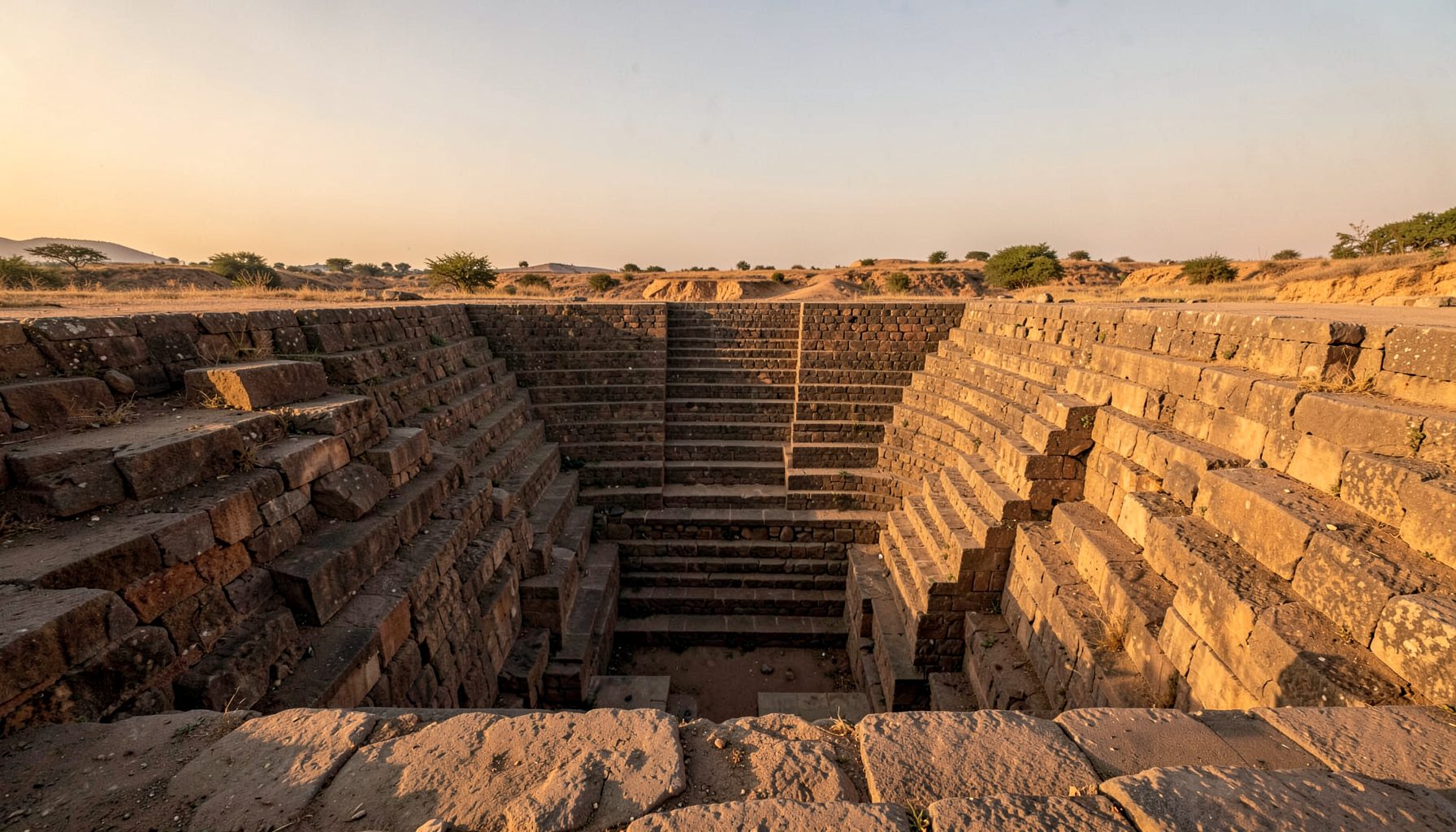
Across western and central India, stepwells were positioned where people, animals and travellers could reach water without entering a settlement. Their location was practical, social and economic. A baoli, bawdi, vav, kund or barav often served a wider landscape than the town enclosed by its walls.
The phrase “outside the city” can be misleading because many historic settlements expanded around older water structures. A stepwell that once stood beyond a fortified boundary may now sit inside a busy neighbourhood, beside a road, or beneath layers of modern construction. Its original setting is often visible only through maps, land patterns and surviving approaches.
For readers in Australia, the idea has a familiar parallel. A town reservoir, stock route waterhole or public rainwater tank may be placed where a whole community can access it, rather than inside one private property. Indian stepwells developed from the same broad principle, but expressed it through monumental architecture, descending galleries and carefully managed groundwater.
Water Beyond The Fortifications
City walls protected a settlement, but they also marked its limits. Houses, markets, workshops and palaces competed for space inside the boundary, while a stepwell required a substantial footprint, open approaches and room for animals to gather. Building beyond the wall allowed patrons to create a public water source without displacing valuable urban land.
The position also reduced pressure on the city’s internal wells. During dry months, residents could collect water at the edge of the settlement, while farmers, herders and passing caravans used the same facility. In this sense, the stepwell was part of a regional water network rather than a private urban amenity. Its users could include people who had no reason to pass through a city gate.
A Landmark On The Road
Many stepwells stood along routes connecting market towns, pilgrimage centres and agricultural districts. Travellers needed dependable water, shade and a place to rest, particularly across the dry landscapes of Gujarat, Rajasthan, Madhya Pradesh and parts of Maharashtra. A large descent into the earth could provide cooler conditions than the exposed road and a memorable landmark for navigation.
Roadside placement also gave a donor’s public work a wide audience. Merchants, rulers, religious institutions and wealthy families could associate their names with generosity and civic responsibility. The structure’s entrance might face a road, while its deeper chambers offered relief from heat. This combination of utility, visibility and prestige helped explain why some stepwells were built beyond formal town boundaries.
Groundwater And Seasonal Change
A stepwell was designed around fluctuating groundwater rather than a fixed water level. Its stairs allowed people to follow the retreating surface during the dry season, while underground corridors and pavilions created shade. Locating the structure near a suitable aquifer mattered more than keeping it close to a palace or bazaar.
The surrounding land could also collect runoff from slopes, fields and seasonal streams. Engineers and builders studied the terrain before choosing a site, creating retaining walls, filtration zones and catchment arrangements suited to local geology. In parts of Maharashtra, baravs were integrated with village landscapes and temple precincts, reflecting the relationship between monsoon rainfall, basalt terrain and groundwater storage. The architecture was therefore a response to place, not simply an ornamental choice.
Public Access And Social Boundaries
A stepwell outside a walled town could function as a shared threshold. People arriving from different directions met at the water source before passing through the gate, making the structure a social and commercial point. Nearby stalls, shrines, resting platforms and animal areas could develop around it.
Access was never perfectly equal. Caste, gender, occupation and religious practice shaped who could draw water, at what time and from which part of the structure. Some stepwells were associated with temples or elite patrons, while others had a more openly civic purpose. Their location beyond the walls did not erase social hierarchies; it made the rules governing access visible within a shared public setting.
This complexity is important when documenting heritage today. A photograph of carved pillars can show craftsmanship, but field research must also record local memories, changing names and community attitudes. The Indian Stepwells archive brings together photography, sketches and site-based research that help connect architectural detail with wider histories of use.
Defence, Risk And Urban Cleanliness
Water inside a fortified settlement could become vulnerable during conflict. Crowded internal wells were easier to contaminate, block or control, especially when a city faced siege or sudden population pressure. An external stepwell did not guarantee safety, yet multiple water points made the wider settlement less dependent on a single source behind the walls.
Distance from dense housing could also help protect water quality. Household waste, animal activity and craft industries created pollution risks in compact urban areas. A stepwell placed on the edge of town could maintain a cleaner catchment, provided its steps, platforms and drainage were managed. This did not make it untouched or pristine: public water structures required rules, repairs and regular cleaning.
Australian cities illustrate a modern version of this separation. Sydney’s reservoirs and Melbourne’s protected catchments are managed away from many everyday urban activities, while Perth’s water planning responds to groundwater pressure and a drying climate. Australians are also accustomed to using rainwater tanks, checking seasonal restrictions and treating water infrastructure as a shared civic responsibility.
The Edge As A Cultural Space
The boundary outside a city was rarely empty. It could contain cremation grounds, shrines, gardens, farmland, caravan routes and seasonal gathering places. A stepwell fitted into this transitional landscape, offering a place where practical needs overlapped with ritual movement. Descending into the earth could carry symbolic meanings connected with fertility, renewal and the life-giving force of water.
Some stepwells became destinations in their own right. Their columns, balconies, carved panels and cool chambers attracted pilgrims and visitors as well as people collecting water. The structure’s architectural drama helped transform an infrastructure project into a civic monument. Comparable processes occur when historic bridges, cemeteries or industrial sites become cultural attractions long after their original function has changed. The discussion of how communities recover older meanings around material heritage can be seen in this account of the Celtic revival.
Reading The Landscape Today
Modern roads, housing estates and commercial development often conceal the former relationship between a stepwell and a city gate. A structure that appears isolated may once have stood beside a busy approach road. Conversely, a stepwell now surrounded by houses may have been located in open fields or on the edge of a village when it was constructed.
Researchers can reconstruct these changes through cadastral maps, oral histories, satellite imagery, inscriptions and comparisons with other wells in the region. Drone photography reveals old alignments, drainage channels and embankments that are difficult to see from ground level. Community reports are equally valuable because residents may know local names or neglected structures that do not appear on official lists. Practical guidance on documenting a site and publishing its story is available through this resource for creating a heritage blog.
Preservation Beyond The Monument
Protecting a stepwell means preserving more than masonry. The surrounding approach, catchment, vegetation, views and relationship with settlement patterns all contribute to its meaning. Fencing a structure without maintaining drainage may save its steps while damaging the hydrology that made the site useful. Conservation therefore needs architectural care, water management and local participation.
This is especially relevant in Maharashtra, where many baravs remain less recognised than the celebrated vavs of Gujarat or the grand baolis of Rajasthan. Documentation can support nominations, educational programs, exhibitions and responsible heritage tourism. A regional survey such as the Maharashtra documentation campaign helps bring attention to sites that may be known locally but absent from wider heritage records.
Australian heritage practice offers useful comparisons. State-based laws, such as the Heritage Act 2017 in New South Wales and the Heritage Act 2017 in Victoria, provide frameworks for registering and managing significant places, while the federal Environment Protection and Biodiversity Conservation Act 1999 can apply to matters of national environmental significance. Yet legal listing alone cannot maintain a water structure. Long-term care depends on accurate records, realistic funding, sensitive visitor access and the involvement of communities who continue to give the site meaning.
Get in Touch
Have information about a stepwell that is not yet on our map? We would be glad to document it and give you full credit. Whether it is a Barav, Kund, Vihir, or any other form of stepwell, every contribution helps preserve India's water heritage.
Call or message us with details about the location, and we will follow up.
#9372496819
Send a Message
What People Say
"The Maharashtra Stepwells campaign has brought attention to structures that were nearly forgotten. The architectural documentation and drone photography are invaluable resources for researchers and students alike."
"Collaborating with the Indian Stepwells team gave our architecture students hands-on exposure to traditional water-harvesting structures. The presentations were insightful and inspiring."
"I shared details of a stepwell near my village that was not on any map. The team visited, documented it beautifully, and credited me. It felt wonderful to contribute."