 Explore Maharashtra
The stepwells of the Thar Desert: Engineering a mirage
In western Rajasthan, the Thar Desert is often presented as an expanse of dunes, thorn scrub and relentless heat. Its historic water architecture tells another story. Built into the dry landscape, stepwells gathered seasonal runoff and groundwater into accessible reserves, creating a carefully engineered mirage: the convincing appearance of abundance where the sky promises almost none.
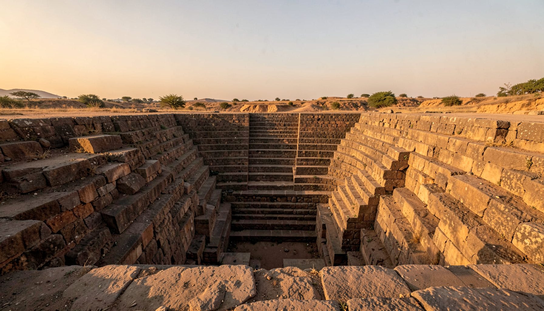
These structures belong to a broad family found across the Indian subcontinent, known by names such as bawdi, baoli, vav and kund. In Rajasthan, many deep wells around Jaisalmer, Bikaner, Barmer and Jodhpur became meeting places, water sources and sacred precincts. Their architecture joins practical hydrology to a theatrical descent from sunlit streets into cool, shadowed galleries.
That combination of engineering and cultural memory is why Indian Stepwells matters to researchers, photographers and curious visitors. Alongside its growing focus on Maharashtra, the site documents historic water systems through original photography, architectural sketches, drone imagery and field research. Its wider desert water heritage also extends the story beyond celebrated monuments to community-held knowledge that rarely reaches formal archives.
Groundwater, dunes and seasonal scarcity
The desert receives a small, erratic monsoon supply, while temperatures can climb beyond 45°C. A stepwell was not a hole filled with unlimited water. Sources varied: some systems received runoff, others intercepted seepage through permeable sand or connected with a local aquifer. Their depth and shade slowed evaporation, while stepped access made a fluctuating resource usable during dry months.
Water management extended beyond individual structures. Nadis, or earthen channels, directed flows, while small check dams called johads aided recharge; silt traps protected well chambers from sediment. Later bore wells and canal irrigation changed the balance. As groundwater extraction increased, some historic systems were left above a falling water table or filled with sediment. Conservation therefore requires an environmental history, not just an architectural portrait: where the water came from, how it moved and what now intercepts it.
Architecture that reveals the hidden water
Entering a stepwell is a measured transition from heat to darkness. Broad flights descend beside pillared galleries, passing shrines, brackets, perforated screens and openings that admit slashes of light. Vaulted chambers and close-set columns create stable temperatures and a strong sense of enclosure. The descending line of steps also makes the water visible from above, turning a hidden source into a civic stage.
Local sandstone, lime mortar and rubble cores allowed builders to work with the ground rather than merely occupy it. At Pabuji ki Dhani near Jaisalmer, a long sequence of flights leads down toward a shaded water court; wells around Jaisalmer and Bikaner reveal variations in carved pillars, niches and screened passages. Measured sketches and carefully timed photographs can expose these relationships more clearly than a quick view, showing how daylight, circulation and water were composed as one system.
More than a reservoir
A stepwell was social infrastructure before it became a photograph. Families drew water, animals were watered, travellers rested, and communities met within its shaded precincts. Worship often reinforced these practical roles, linking water with fertility and protection. Accounts from different cities also associate wells with queens, officials, saints or charitable foundations, giving each structure a civic identity.
Traditional maintenance depended on neighbourhood knowledge, including cleaning, repair and management of access. The loss of those systems can be as damaging as cracked stone. Residents may know a well’s seasonal behaviour, local names or vanished paths that archival plans omit. Any serious record should combine built evidence with lived testimony, while ensuring that contributors control how their stories are credited and shared.
A Thar perspective from Australia
Australian readers have a useful vantage point on water scarcity. In Alice Springs, summer temperatures regularly pass 40°C, and rainwater tanks, bores and careful household allocation are familiar parts of dry-country life. The regional parallel is not exact, but it shows how a hot climate shapes everyday habits, public discussion and the design of shared infrastructure.
Sydney and Adelaide sharpen the contrast. Sydney households in bushfire-prone catchments use rainwater tanks under rebate schemes, while conservation messaging links personal saving to catchment health. Adelaide experiences hot, dry summers and intense winter storms; its older buildings and gardens have long relied on cisterns, shaded courtyards and systems that capture a brief deluge for later use. Melbourne’s variable seasons add another lesson: a reliable design must respond to a changing annual rhythm.
Local markets make the subject tangible. At Fremantle Markets and smaller growers’ markets around Perth, shoppers meet producers who understand dry summers, irrigation limits and the value of every litre. The familiarity of Western Australian fruit and vegetables creates an opening for discussing the hidden labour of water behind food and heritage. It also offers a reason to support documentation near Indian communities rather than treating the desert as an abstract picturesque setting.
Australian planning culture also attaches strongly to sport and betting. Melbourne and Sydney pubs display football, racing and casino promotions, while online campaigns target regular customers. A page explaining blackjack dealer rules illustrates the value of stated procedures when chance enters a room. Stepwell research needs comparable discipline: dates, measurements and reconstructed features should never be presented with the confidence of direct observation.
Separating evidence from digital noise
Search results increasingly mix heritage travel with commercial material: a visitor may encounter an online casino deposit guide before a conservation report. The pairing is a useful reminder that prominence is not authority. A heritage page should disclose its sources, distinguish photographs from archival evidence and mark interpretation as interpretation, rather than borrowing the confidence of polished promotion.
For stepwells, that means recording each visit’s location, season and condition; retaining original images; citing historical maps and published surveys; and explaining whether a drawn arch was observed, photographed or inferred. Community testimony should receive the same care, with consent and attribution. Clear methods turn visual appeal into knowledge, allowing readers to assess a site rather than simply admire it.
A field practice built on respect
Documentation works best when it joins close observation to local participation. A field team can measure levels, trace channels, sketch elevations and compare seasonal change, but it cannot infer every use or meaning from masonry alone. Interviews with residents, temple caretakers, water managers and former users can reveal routes, names and maintenance practices that photographs miss. These conversations should be collaborative rather than extractive, with credit, consent and shared control of images.
Preservation also needs an active future. A visually repaired well with no functioning catchment or community connection is a monument, not a living water system. Monitoring water quality, silt, structural movement and groundwater requires long-term partnerships, careful permissions and realistic maintenance plans.
- Establish precise locations and environmental context, including drainage, sediment and groundwater conditions.
- Photograph with consistent framing and scale, keep original files, and record dates, permissions and weather.
- Pair measured sketches with drone imagery, clearly identifying later repairs and features hidden below ground.
- Mark each claim as observed, reported, archival or inferred so readers can judge its reliability.
- Credit oral histories and community-held knowledge, returning findings in accessible formats.
- Connect documentation to practical stewardship, including maintenance, water-quality checks and seasonal monitoring.
The enduring achievement of a Thar stepwell was never the creation of an optical illusion. It was the construction of a durable relationship between people, architecture and a finite aquifer. Preserving that relationship requires both a sharp eye for evidence and sustained attention to place.
Get in Touch
Have information about a stepwell that is not yet on our map? We would be glad to document it and give you full credit. Whether it is a Barav, Kund, Vihir, or any other form of stepwell, every contribution helps preserve India's water heritage.
Call or message us with details about the location, and we will follow up.
#9372496819
Send a Message
What People Say
"The Maharashtra Stepwells campaign has brought attention to structures that were nearly forgotten. The architectural documentation and drone photography are invaluable resources for researchers and students alike."
"Collaborating with the Indian Stepwells team gave our architecture students hands-on exposure to traditional water-harvesting structures. The presentations were insightful and inspiring."
"I shared details of a stepwell near my village that was not on any map. The team visited, documented it beautifully, and credited me. It felt wonderful to contribute."