 Explore Maharashtra
The Stepwells of the Sahyadri Hills: hidden in plain sight
In the Sahyadri Hills, rainwater has long shaped both the landscape and its architecture. Seasonal downpours run over steep slopes, gather silt and feed the fractured basalt and alluvial aquifers below. Stepwells were built to hold that water through the long dry months. Their architecture can look sculptural and almost ceremonial, yet it grew from an intensely practical concern: how to capture a seasonal flow and keep it available for a community.
Yet these places are easily missed. A baoli may sit below a village street; a bawdi may open behind a house; elsewhere, a vav, kund or barav may occupy an ordinary compound. From the road, their presence can be as understated as a flight of steps disappearing into shadow. That hidden quality is not an argument for mystery. It reflects how closely the waterworks were woven into daily life, close enough to be used, maintained and remembered by the people living beside them.
Monsoon water and Sahyadri stone
The terminology shifts with region and language. A bawdi in Rajasthan, a baoli in the Deccan and a vav in Gujarat can belong to related water-harvesting traditions without sharing identical plans. Some remain simple shaft wells with a landing; others descend through broad flights into a reservoir, with colonnades, corridors and rooms arranged around the void. Local names often describe a well, tank, pool or cistern, placing function before monumentality.
The Sahyadri setting gives particular force to that relationship. Steep escarpments channel rain rapidly, while seasonal streams cut into slopes and carry sediment towards the plains. A well dug at the wrong elevation could remain dry; excessive excavation could weaken adjoining ground. Builders responded with terraces, retaining walls, stone steps and carefully positioned openings to collect water, limit erosion and make it accessible. The result is both architecture and hydraulic engineering, though it should never be reduced to a technical diagram.
Panchakki in Nashik offers a useful example of a baoli tied to movement and work, traditionally used to water horses and palanquins. Its present stillness contrasts with that practical past. Around it, Nashik has changed, yet the descent still regulates light, temperature and sound. Such details reward a slower visit: notice where daylight reaches, how the stone is worn at the water’s edge, and how modern roads sit against much older levels of ground.
Reading the underground landscape
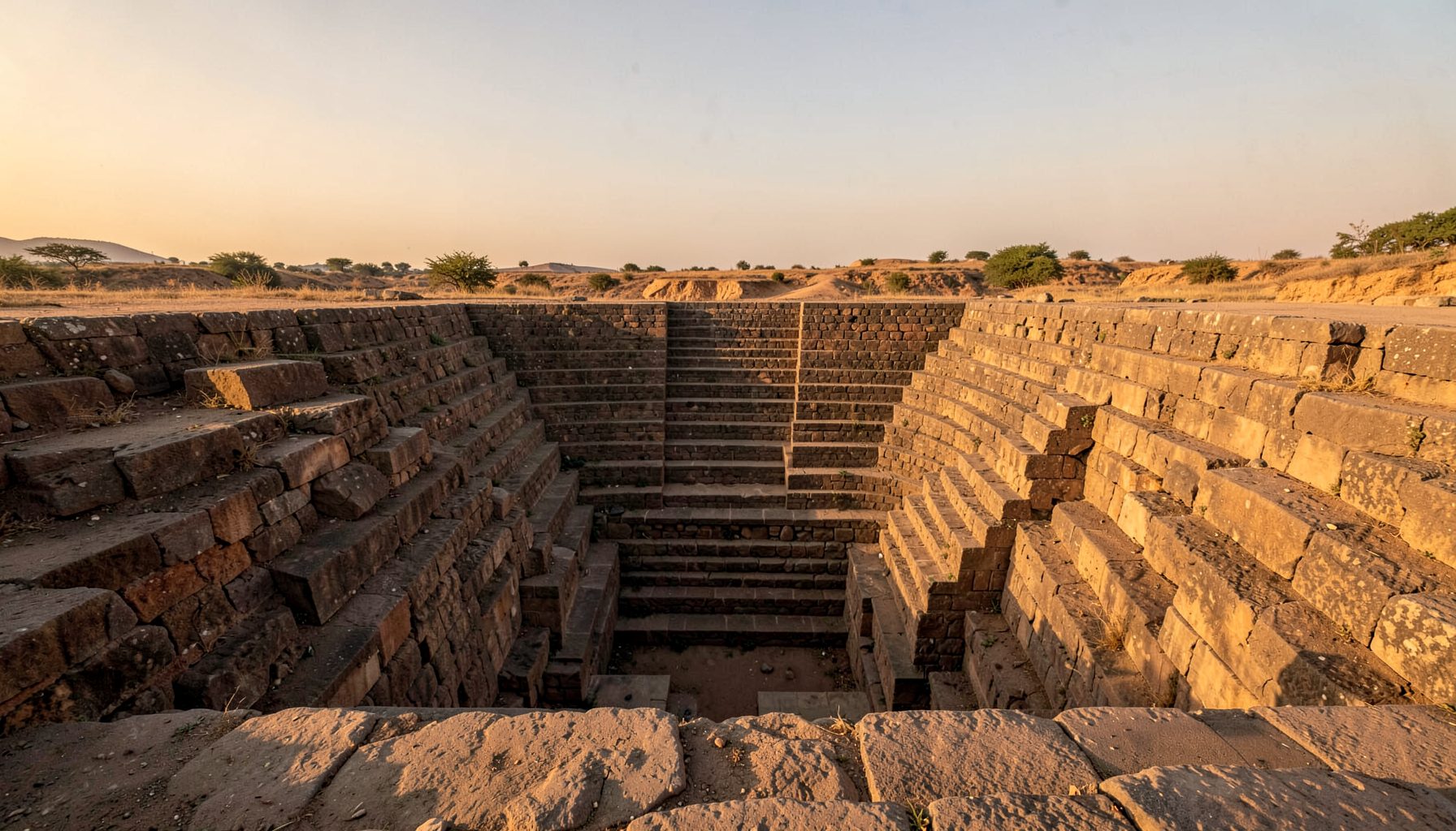
For a first-time visitor, the descent can feel like entering a cutaway drawing. Steps create a measured transition from bright exterior to cool enclosure. The eye moves from parapet to landing, from landing to reservoir, while patches of sky narrow above. Water may occupy only part of the deepest space, leaving mineral lines and sediment to describe former levels. Stone also keeps a record of touch: rounded edges on frequent treads, sharper edges on rarely used ledges.
Different levels perform different roles. The upper court handles arrival and circulation; intermediate landings mark changes in height; lower platforms bring people close to the water. Niches may have practical or devotional purposes. A roof or covered gallery can make the approach cool without mechanical air-conditioning. Seen from above, a plan may look symmetrical; from within, it becomes an accumulation of thresholds, shadows and changing views.
Photography makes this legible, but only if the frame retains context. Wide views explain the relationship between a stepwell and its settlement; close studies of masonry, mineral staining and worn edges reveal use. Drone imagery adds another reading, showing how a structure meets paths, fields or roofs. Sketching remains valuable because it records relationships that a single photograph can hide. A compelling record may combine all three: an overhead outline, a human-scale view and a measured detail.
A field checklist for Australian visitors
The site’s research background sets out an independent approach to this heritage, combining field research, original photography, architectural sketches and drone imagery. That combination suits a subject whose meaning lies in relationships. A plan can show the reservoir, but not the wear made by generations of feet; a photograph can show atmosphere, but not the direction of the slope. Each kind of record checks the assumptions built into the others.
For many Australian visitors, the seasonal contrast is immediate. Adelaide’s dry summers and Perth’s waterwise gardens provide a familiar reference for conserving water, while Melbourne’s laneways offer another kind of lesson in discovering a space that does not announce itself. Such comparisons can sharpen attention to the stepwell’s setting without turning it into a curiosity from elsewhere.
- Start with the water system, tracing where runoff enters the site and where the reservoir drains.
- Photograph the threshold, not just the deepest view; the entrance explains how the stepwell joined the settlement.
- Record scale with familiar details, such as steps, doorways and hand-height changes in masonry.
- Ask local residents what the site is called and what they remember about its water use.
- Check access, permissions and local guidance before entering, particularly where water levels or masonry are uncertain.
Memory beneath the ground
A stepwell stores water, but its deeper archive is social. Names change, wells silt up, families maintain sections, and communities adapt old structures to new needs. Such details rarely appear on a monument sign. They emerge through repeated visits and patient conversation, which is why field recording works best when it includes the people who live around a site rather than treating them merely as sources of background information.
Subterranean heritage has parallels elsewhere. In Dublin’s St Patrick’s Cathedral, the Guinness family crypt shows how an underground chamber can preserve the history of a family, its craft and patronage. The architectural context is entirely different, yet both spaces reveal the character of their communities through what people chose to place below ground. A Sahyadri stepwell records a shared resource and ordinary routines; a family crypt can carry the weight of lineage and status.
Australian audiences may recognise this shift from grand architecture towards layered stories. In Sydney and Hobart, heritage interpretation often involves local councils, historical societies, museums and property owners. Across Australian heritage circles, “social value” is a familiar term used alongside fabric and setting. Exhibitions, publications and commissioned surveys create routes for images and research to circulate, with consent and attribution determining whether those relationships hold. A striking image can open a conversation, while a careful record keeps the community in view and gives exhibitions a credible foundation.
Preservation through shared stewardship
Preservation has to hold two truths at once: the structures are vulnerable to water, salt, biological growth, silt, groundwater extraction and nearby development, yet their age and irregular repairs are also evidence. Removing every trace of disrepair can erase the record of how a place adapted. The first task is therefore observation, rather than cosmetic repair, and the people closest to a site should help define what counts as significant.
The Indian Stepwells Maharashtra campaign turns that principle into a public research effort, pairing site visits with imagery and community knowledge. Its invitation to share information about undocumented stepwells is especially important. A structure known locally by an old name, or remembered as a place for washing or collecting water, may be absent from official records. Such testimony can open the way to careful survey, proper consent and conservation planning.
- Establish a baseline with dated photographs, measured drawings and notes on access and condition.
- Map the relationship between the reservoir, slopes, streets, fields and nearby buildings.
- Record local names and oral histories with informed consent and clear attribution.
- Prioritise safety and structural stability before restoring appearance or visitor access.
- Keep photography, exhibitions and fundraising connected to long-term community stewardship.
For a heritage structure often tucked away behind an ordinary frontage, careful documentation can be the first act of protection. It identifies what is present, establishes its relationships and gives conservation decisions something firmer than an impression. The reward is a record that belongs to the place as much as it does to the screen.
Get in Touch
Have information about a stepwell that is not yet on our map? We would be glad to document it and give you full credit. Whether it is a Barav, Kund, Vihir, or any other form of stepwell, every contribution helps preserve India's water heritage.
Call or message us with details about the location, and we will follow up.
#9372496819
Send a Message
What People Say
"The Maharashtra Stepwells campaign has brought attention to structures that were nearly forgotten. The architectural documentation and drone photography are invaluable resources for researchers and students alike."
"Collaborating with the Indian Stepwells team gave our architecture students hands-on exposure to traditional water-harvesting structures. The presentations were insightful and inspiring."
"I shared details of a stepwell near my village that was not on any map. The team visited, documented it beautifully, and credited me. It felt wonderful to contribute."