 Explore Maharashtra
Water architecture across the Narmada basin
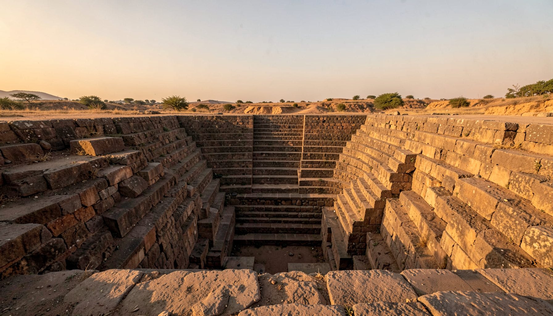
The Stepwells of the Narmada Valley: A Preliminary Survey is a working field study of the region’s historic water-conservation structures. It follows the Narmada through its upper, middle and lower landscapes, asking how masonry wells, descending flights and reservoir chambers were adapted to local geology, climate and settlement. The aim is not to impose a single origin story, but to create a verifiable record of structures often known only through village memory or scattered archival references.
The survey treats the river as a corridor of connected communities rather than a neat boundary between Madhya Pradesh, Gujarat and Maharashtra. It brings together site photography, architectural sketches, seasonal observation and oral testimony, while distinguishing a stepwell from a kund or ordinary tank where possible. As preliminary work, its inventories remain open to revision; that qualification is essential when access, ownership and culturally sensitive knowledge shape what can be documented.
A basin shaped by water and stone
The Narmada drains a broad and diverse catchment before reaching the Gulf of Khambhat. Its valley links sandstone and alluvial landscapes in Madhya Pradesh with the lower plains of Gujarat and adjoining Maharashtra. Rainfall is strongly seasonal, evaporation is high, and settlements have long depended on groundwater as well as river water. A stepwell is therefore more than an ornamental stairway; it is a piece of hydraulic engineering embedded within a wider water system.
Names change with distance and language. Vavs in Madhya Pradesh often appear as deep, narrow shafts with long flights; bawdis or baolis in Gujarat may have broader terraces, pillared corridors and multiple access levels. Kunds and baravs belong to related water-management traditions but need separate descriptions. A preliminary survey should record local terminology before deciding which English category best fits a structure, because functional similarities do not erase differences in date, design or use.
The working area follows the valley and selected tributaries, including settlements absent from standard tourism maps. Early observations suggest that sites cluster around former routes and settlements rather than occurring evenly, while their condition varies with groundwater, later repairs and present use. Architecture also records labour: quarrying, transporting stone, shaping steps, maintaining channels and managing water were collective tasks that a photograph of the staircase alone cannot reveal.
Building a verifiable site record
Each location needs a consistent record: coordinates, orientation, dimensions, present water level and the date and weather conditions of the visit. Photographs should move from general setting to approach, stair geometry and small construction details. A measured sketch can clarify changes in level, wall thickness and circulation more effectively than a wide view alone, while a drone image may show the relationship between the well, streets and surrounding fields.
Condition assessment should be equally precise. Surveyors can note erosion, blocked outlets, salt deposits, vegetation, settlement and incompatible repairs without making structural diagnoses too quickly. The status of water should be recorded separately from the value of the monument: a dry shaft may still be architecturally important, while a wet well may require advice before entry. Permissions, safety conditions and local restrictions remain essential.
For public presentation, the format developed by Indian Stepwells offers a useful model: original photography, architectural sketches, drone imagery and field research presented with concise notes that separate direct observation from interpretation. A standard template also allows entries from different districts to be compared. The strongest records will retain alternative spellings of place names, mark uncertain readings and show how the available evidence changed with each field visit.
Reading masonry, water and memory
A stepwell invites interpretation through sequence. The threshold, descending stair, intermediate landing, lower chamber and final water source create a progressive change in light, sound and temperature. Niches, carved figures, inscriptions and offering spaces can indicate uses that are not obvious from the engineering alone. These elements should be documented as features with context, rather than assigned a meaning merely because they resemble motifs found elsewhere.
Comparative cultural study can sharpen this caution. The discussion of Victorian grave symbolism shows how an upward-pointing hand could communicate grief, hope and belief in an afterlife in a very different setting. That parallel does not supply a code for Indian monuments, but it demonstrates why symbols should be interpreted with their own religious and social traditions, not treated as universal decoration.
Community testimony is part of the evidence, not an illustration added after architectural study. Former users and descendants may know alternative names, seasonal water behaviour, vanished shrines or paths now hidden by construction. Interviews should record disagreement and uncertainty as well as consensus. With consent and attribution, this knowledge can correct maps, reveal recent changes and identify practical priorities for conservation.
An Australian lens on field research
For Australian readers, water stewardship has familiar forms. Households in Melbourne and Adelaide often manage rain-water tanks, and people in Sydney, Brisbane and other cities routinely check water restrictions, refill bottles and watch summer forecasts. Indian groceries in neighbourhood shopping strips and the multicultural stalls at Adelaide Central Market create everyday connections to the cultures represented by these structures. Heritage photography can enter those familiar spaces through exhibitions and community events.
Heritage law in Australia is divided among states and local councils. The Victorian Heritage Act 2017, NSW Heritage Act 1977 and municipal overlays can each affect what may be changed around a historic site. Aboriginal heritage protections and Traditional Owner protocols may add further legal and ethical requirements. Field researchers should therefore identify the relevant jurisdiction, consult custodians early and distinguish a site’s architectural significance from its living cultural value.
The following checklist keeps the survey approachable while protecting both evidence and participants. The first group records the physical and hydraulic setting:
- Position, orientation, access route, dimensions, local names and any mapped heritage references.
- Stair flights, landings, chambers, outlets, niches, wall construction and changing floor levels.
- Water depth or dryness by season, with adjacent uses, drainage, salinity, erosion and structural disturbance.
- Wide, detail and measured images, including scale markers and drone views only where lawful and safe.
A second group places each structure within its present social and legal setting:
- Oral histories, maintenance practices, former uses, ritual associations and memories of flooding or drought.
- Ownership, access rights, community concerns and the priorities of people who care for the place.
- Planning status, relevant state or local legislation, environmental conditions and consultation requirements.
- Consent for names and photographs, agreed attribution, privacy safeguards and copies retained by contributors.
From survey records to shared stewardship
Documentation is only the first stage. Population growth, groundwater change, road building, siltation and tourism can alter a stepwell’s setting before formal listing is considered. A survey should therefore note pressures visible in the present while avoiding assumptions about cause. Conservation plans can then combine structural evidence with community priorities such as safe access, ritual continuity, groundwater protection or improved interpretation.
The site’s Maharashtra campaign shows how a regional campaign can turn scattered information into a public research programme. The Narmada survey can use a similar model by coordinating district teams, local historians, photographers, hydrologists and municipal officers. Shared templates and open captions would make records searchable without publishing sensitive coordinates or claims that have not been checked.
Future seasons should revisit sites as water levels, vegetation and conservation work change. Photographic baselines, corrected plans and attributed testimonies will allow later researchers to identify drift rather than mistake it for historical form. A preliminary survey becomes most valuable when it remains revisable and shared: a public account of how water was found, stored and honoured across the Narmada Valley.
Get in Touch
Have information about a stepwell that is not yet on our map? We would be glad to document it and give you full credit. Whether it is a Barav, Kund, Vihir, or any other form of stepwell, every contribution helps preserve India's water heritage.
Call or message us with details about the location, and we will follow up.
#9372496819
Send a Message
What People Say
"The Maharashtra Stepwells campaign has brought attention to structures that were nearly forgotten. The architectural documentation and drone photography are invaluable resources for researchers and students alike."
"Collaborating with the Indian Stepwells team gave our architecture students hands-on exposure to traditional water-harvesting structures. The presentations were insightful and inspiring."
"I shared details of a stepwell near my village that was not on any map. The team visited, documented it beautifully, and credited me. It felt wonderful to contribute."