 Explore Maharashtra
The stepwells of the Mahi River region: a photographic archive
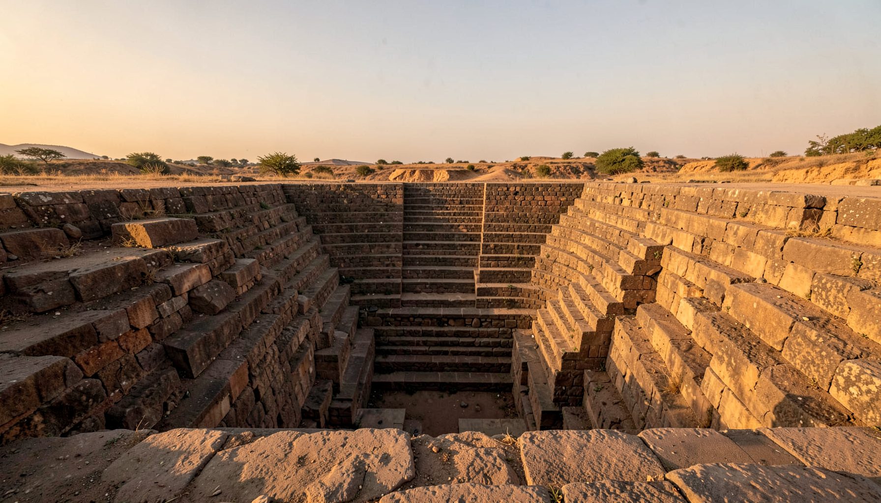
Along the Mahi River basin, water has always been negotiated between monsoon rain, dry soil and the settlements that depend on it. Stepwells turn that negotiation into architecture: descending flights reach shadowed reservoirs, carved galleries frame changing light, and narrow channels direct water into shared tanks. Known locally as bawdis, baolis, vavs, kunds and baravs, these structures became civic places as well as water sources, joining utility, devotion and public life.
This photographic archive follows that complexity across western India, with Kuteshwar near Kheda as a familiar anchor and village-scale structures supplying a wider geographical frame. Original ground-level photographs, measured sketches and carefully used aerial views work together to show how builders fitted stone architecture into terrain. The result is a record of interconnected systems: recharge, storage, access, maintenance and memory.
Water shaped the Mahi basin
The basin receives strongly seasonal rain, yet much of the landscape can remain dry for long stretches. A stepwell concentrates the resource rather than treating every household or field as an isolated consumer. Runoff enters through channels, passes down stepped terraces and collects in a deeper tank, where evaporation is slower and sediment can settle.
These structures also regulate the relationship between surface water and groundwater. Their shafts, porous masonry and carefully graded floors can encourage percolation, although their real performance depends on local geology, upkeep and the condition of neighbouring channels. A photograph records appearance; field notes record how that system actually functioned.
Local vocabulary preserves distinctions that a single English label can blur. A vav may be a deep stepped well, a baoli a reservoir reached by stairs, and a kund or barav may name a tank, well or broader waterwork depending on the district. The archive records these names with place and date, allowing architecture to remain attached to local speech.
Reading stone, water and depth
A stepwell is read vertically as well as horizontally. Descending stairs establish a measured relationship with the sky, while landings reveal how the structure was divided for circulation and gathering. Pillars, brackets, niches and worn steps reveal craft and use over time. Wide-angle frames can hold the whole shaft, but smaller details matter just as much.
The photographic method therefore mixes scales. Low viewpoints emphasise the temperature and darkness below ground; raking light picks out carved edges; and a figure placed carefully out of view gives scale without turning the image into a posed portrait. Contact sheets retain subtle changes in masonry that a single polished frame can hide.
Aerial imagery adds another layer rather than replacing the human view. It reveals roof plans, approach paths and the relationship between a well and the river, field or settlement around it. Because drone use in India can vary by site and circumstance, every image is tied to notes explaining altitude, direction and conditions.
From Kuteshwar to village wells
At Kuteshwar, beside the Mahi near Kheda, the river connection and the stepwell’s own vertical world can be understood together. The lower galleries sit close to flowing water, yet the approach remains a sequence of landings and shadowed passages. Photographs taken at different times show how light, water level and movement alter the building’s apparent character.
Beyond such landmarks, the basin’s smaller wells reveal how water systems served villages and dispersed settlements. A modest bawdi may connect to a neighbourhood tank, a field channel or a seasonal stream through a network that does not appear on many tourist maps. These modest structures are vulnerable because local use can be mistaken for abandonment.
The wider Indian Stepwells project has built an independent, visually led record of these structures, and its current attention to Maharashtra offers a useful comparison with the western Indian material. The Indian Stepwells project combines original photography, architectural drawing and field research while also welcoming reports of undocumented wells from local communities.
A rigorous way to photograph the inaccessible
An archive of difficult places needs method as much as imagery. Fieldwork records access, orientation, material condition and the relationship between a visible monument and later repairs. Sketches clarify plans and construction sequences that photographs cannot fully reveal. Repeated visits also distinguish durable design from recent repairs or accumulated debris.
A parallel with an early Christian Dublin souterrain burial is useful for a different reason: both underground structures become legible only when access is careful and movement is respectful. The Dublin example shows why context matters when recording a hidden or altered place. Neither site should become an abstract specimen; photographs remain tied to routes, objects and community memory.
Drone imagery can clarify form, but it must follow local restrictions and avoid treating a living sacred landscape as an empty geometric object. Where permission is uncertain, ground-based and remote images can carry the record. Oral histories from residents add information that may not appear in masonry: former water levels, festival routes, repairs and changing groundwater use.
The archive in Australian hands
For Australian viewers, the photographs can sit comfortably within familiar public culture. Melbourne’s laneway galleries and community photography walks offer a close parallel. The produce stalls and long aisles of Queen Victoria Market supply a comparable mix of colour, repetition and working detail, while Sydney’s harbour rain and busy Fish Market add another locally familiar relationship between weather, water and crowded space.
The archive’s visual record can be read through two related sets of observations. The first records the built environment:
- Stepped access corridors, carved galleries and the changing play of daylight.
- River terraces, village tanks, channels and seasonal water conditions.
- Masonry details revealing workmanship, repair and long use.
- Aerial relationships between each well, its settlement and surrounding land.
The second focuses on relationships and change. Together, these images support inquiries into form, environment, stewardship and the changing value of a shared resource:
- Connections between rainwater capture, groundwater recharge and everyday access.
- Social rooms, passages and thresholds built into water architecture.
- Conservation needs expressed through cracks, erosion, sediment and encroachment.
- Community knowledge that may identify hidden channels or vanished structures.
A tablet is also useful for organising contact sheets, captions and location notes while travelling between Melbourne, Sydney and other collection points. Indian Stepwells provides a broader Australian iPad guide for readers arriving through mobile search, although its subject sits apart from the heritage material itself.
Keeping the record alive
Preservation begins with accurate knowledge. If a structure is mapped only as a tourist attraction, its drainage channels, local material sources and maintenance traditions may be overlooked. A photograph can show a blocked outlet, but interviews with residents and masons can explain why it matters. Documentation therefore supports conservation and informed stewardship.
A durable digital record should keep original files, captions, sketches, coordinates and permission details together rather than merely circulate a compressed gallery image. Versioned records can show how access, weather and restoration alter a site over time. They also give researchers a defensible base for comparing photographs made years apart.
The Mahi archive’s lasting value lies in this layered evidence. It records a regional water vocabulary, the ingenuity of stone and the social life gathered around wells while preserving distinctions between places that share similar forms but carry different histories. Seen together, the images make a compelling case for treating every stepwell as part of a living cultural landscape rather than an isolated monument.
Get in Touch
Have information about a stepwell that is not yet on our map? We would be glad to document it and give you full credit. Whether it is a Barav, Kund, Vihir, or any other form of stepwell, every contribution helps preserve India's water heritage.
Call or message us with details about the location, and we will follow up.
#9372496819
Send a Message
What People Say
"The Maharashtra Stepwells campaign has brought attention to structures that were nearly forgotten. The architectural documentation and drone photography are invaluable resources for researchers and students alike."
"Collaborating with the Indian Stepwells team gave our architecture students hands-on exposure to traditional water-harvesting structures. The presentations were insightful and inspiring."
"I shared details of a stepwell near my village that was not on any map. The team visited, documented it beautifully, and credited me. It felt wonderful to contribute."