 Explore Maharashtra
The Lone Stepwell of Lohagad: A Watered Fort in the Western Ghats
Rising abruptly above the mist-soaked valleys near Lonavala, Lohagad Fort holds a quiet surprise: a multi-tiered stepwell tucked into its hillside, far from the plains where such water monuments are usually found. The structure is rare enough to be considered singular among the fortified strongholds of the Sahyadri range. For travellers familiar with the sandstone gorges of Australia's Blue Mountains, the prospect of tracing an underground water system inside a Maratha-era citadel offers a comparable sense of layered discovery.
This case study examines the Lohagad stepwell as both an architectural specimen and a piece of living heritage. It also considers how field researchers working between Mumbai, Pune, Sydney, and Melbourne might document such remote sites, applying the methodical approach championed by Australia ICOMOS and the Burra Charter to underground water heritage far outside their home landscapes.
Lohagad's geographic and historical setting
Lohagad perches at roughly 1,033 metres in the Pune district of Maharashtra, guarding the Bor ghat pass that once linked the Deccan plateau to the coastal Konkan. The fort's commanding position made it a prized stronghold across centuries, passing from the Satavahanas through the Chalukyas, the Bahmani sultans, the Nizam Shahis, and finally the Marathas under Chhatrapati Shivaji Maharaj. Local guides near Lonavala still trace the old mule tracks once used by soldiers hauling supplies and water up the slopes.
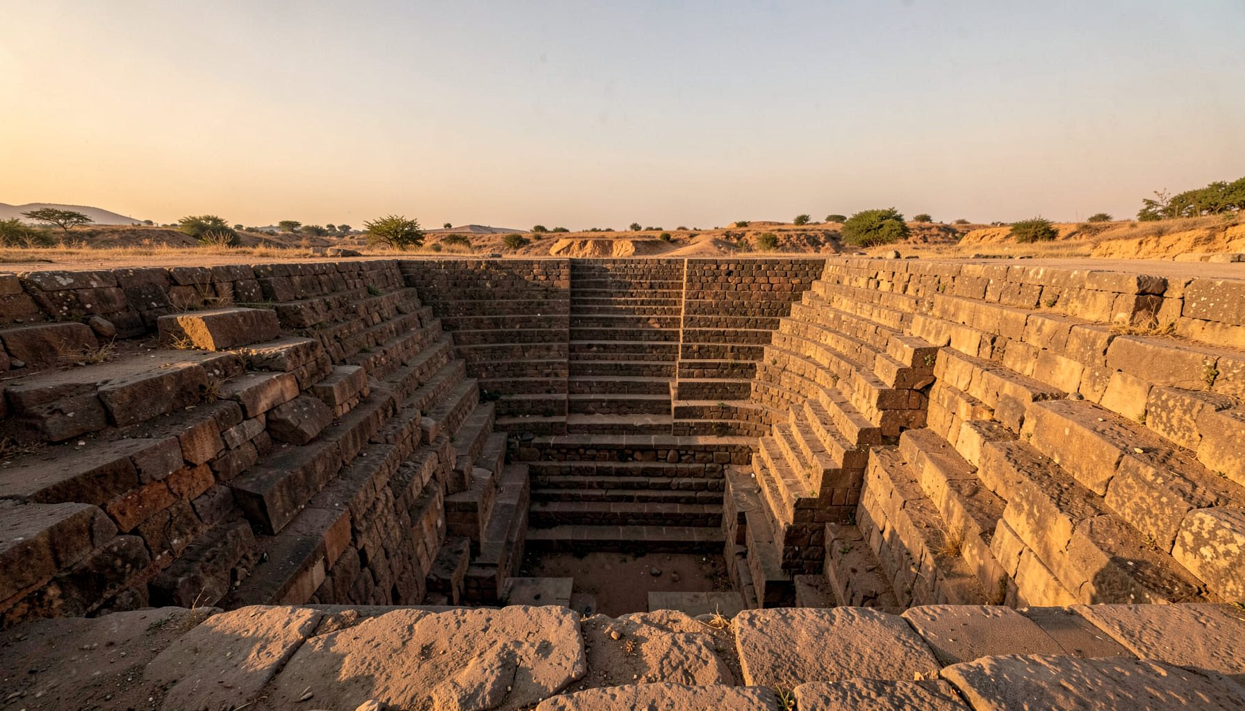
The stepwell, referred to in modern field notes as Vincho Bavdi, lies on the southern flank of the fortification, just inside one of the ruined gateways. Its position is deliberate: close enough to the inner bailey to serve soldiers in a siege, yet screened from direct line of sight from competing hilltops. Visitors approaching from the villages below cross terraced fields before the gradient steepens into stone-paved stairways cut into basalt.
Engineering a water source on a hilltop
Building a multi-storey stepwell on elevated terrain demands a different logic from the broad-plain vavs of Gujarat or the deep urban baolis of Delhi. Lohagad's catchments drew on exposed basalt outcrops that shed monsoon deluges into cut channels, funnelling runoff into an underground tank carved directly into the rock, with a stepped shaft descending through successive landings to a perennial water level.
The compact, partly shaft-and-chamber form reflects the limited plateau at the top of the hill, where every square metre competes with gun positions, granaries, and sleeping quarters. Field surveys by Indian Stepwells have measured the descent at roughly forty steps across multiple flights, with small side alcoves that may once have stored pots or weapons. The same instinct that placed the source where rain falls fastest informs rock-cut cisterns on remote Australian pastoral stations, where engineers solved similar problems using only locally available stone.
Architectural features and visual documentation
The visible architecture is austere but considered. Square-section pillars frame the landings, their capitals cut in a simple style common to early Maratha work. The walls show tool marks from the original dig, partly dressed where visitors have touched them and untouched where lichen now preserves the original chisel pattern. A few carved niches may have held oil lamps during the dry months.
Documentation combines close-range photography, drone overviews, and measured architectural sketches. The site's restricted footprint makes hand-drawn plans as useful as photogrammetry, and on-site sketches often capture flow lines that no drone can resolve from above. A small drone flight above the southern gateway shows how the stepwell's roof sits just below the fort's main parade ground, a placement that helps it collect both direct rainfall and runoff swept from the courtyard.
Water security in a military fortress
Stepwells in plains served temples, caravanserais, and town quarters. A stepwell inside a fort must answer a different set of demands. The Lohagad source provided year-round water to a garrison that might otherwise depend on risky supply lines during the monsoon, when neighbouring hilltops were visible but cut off by rushing streams.
Siege records from the Maratha period note that Lohagad fell less often by storm than by starvation and thirst, indicating that commanders understood the strategic importance of protected water. The stepwell formed part of a wider network that included rock-cut cisterns elsewhere on the ridge, but its walkable descent made it the preferred daily source. This reliance on a single, well-defended water point is comparable in spirit to centralised water-supply arrangements in arid regions, where a single well or tank underwrites survival across vast distances.
A comparative reading among stepwell traditions
The Indian Stepwells archive documents bawdis, baolis, vavs, kunds, and baravs across the subcontinent, and the comparative collection frames Lohagad as an outlier. Most documented examples sit within active settlements or beside pilgrimage routes. Step wells carved into hill forts appear in fragments at a handful of Deccan sites, yet few match the depth, preservation, and accessibility of the Lohagad example.
The closest architectural cousins are the partly buried tanks of the Karnataka Deccan and the rock-cut water features at Rajgad and Raigad, yet none presents the full stepped descent of a true stepwell in working order. Lohagad therefore serves as a useful reference object for studying how stepwell builders adapted a familiar typology to unfamiliar terrain, a question that resonates in Australia, where engineers continually re-adapt European water typologies to dry-climate realities from Kalgoorlie to Cairns.
Field research methods and the photographic record
The research workflow developed for Lohagad prioritises minimum disturbance and maximum repeatability. Each visit begins with photographic registration under consistent lighting, followed by a sketch survey that records column positions, step dimensions, and any modern intrusions such as plastic waste or cemented repairs. Drone imagery covers the immediate precinct to record surface drainage.
Measurements are entered into a standardised template so future researchers can extend the record without ambiguity. The project's main contact channel offers a direct route for communities near Lonavala and other districts to flag undocumented structures. Through similar methods, partner projects such as the Tazkra heritage portal have applied a shared-template approach to water heritage across borders, and a growing collection of sketches, photographs, and drone passes allows a single fort stepwell to be studied months or years apart with minimal loss of reference data between visits.
Heritage value and preservation challenges
The principal pressure on Lohagad's stepwell comes from the same forces affecting many Indian heritage places: weekend tourism from Mumbai and Pune, along with informal repairs that erode original fabric. Visitors enter the structure in growing numbers, and the soft stone of the landings shows wear patterns that were not present a decade ago. Rubbish accumulates in the lower chambers each post-monsoon season.
Preservation planning can draw on precedents established under Australia's National Heritage List and the fabric-first philosophy embedded in the Burra Charter, which emphasises stabilisation over restoration, reversibility of interventions, and ongoing community involvement. A modest programme of visitor-path marking, paired with awareness sessions in nearby schools, would reduce inadvertent damage without restricting reasonable access. For anyone interested in contributing observations, photographs, or local knowledge about undocumented stepwells in Maharashtra, the team welcomes submissions through the site's contact page.
Practical guidance for researchers and travellers
A handful of habits make field visits far more productive, whether the site is two hours from Pune or a long flight from Sydney.
- Travel in the cooler dry months, arriving before mid-morning so harsh overhead light does not flatten the underground depth.
- Carry a small sketchbook and a hand-held light; measured drawings reveal information that photography can miss in dim interiors.
- Coordinate with local guides, as certain fort gates close during heavy monsoon rains.
- Record any recent graffiti or damage immediately, with date and GPS, so conservators can prioritise repair work.
- Cross-check notes with existing documentation before publishing, as the same structure has been named differently across historical records.
- Share unpublished material openly so the wider stepwell community can benefit from fresh measurements and images.
Get in Touch
Have information about a stepwell that is not yet on our map? We would be glad to document it and give you full credit. Whether it is a Barav, Kund, Vihir, or any other form of stepwell, every contribution helps preserve India's water heritage.
Call or message us with details about the location, and we will follow up.
#9372496819
Send a Message
What People Say
"The Maharashtra Stepwells campaign has brought attention to structures that were nearly forgotten. The architectural documentation and drone photography are invaluable resources for researchers and students alike."
"Collaborating with the Indian Stepwells team gave our architecture students hands-on exposure to traditional water-harvesting structures. The presentations were insightful and inspiring."
"I shared details of a stepwell near my village that was not on any map. The team visited, documented it beautifully, and credited me. It felt wonderful to contribute."