 Explore Maharashtra
The forgotten stepwells of the Kathiawar Peninsula
Across the Kathiawar Peninsula in western Gujarat, water architecture survives in places that rarely appear on standard tourist itineraries. The region’s vavs, vavdis, kunds and rock-cut wells were built for practical use, religious observance and community life. Some stand beside busy roads or temple precincts; others are hidden behind houses, swallowed by vegetation or reduced to a name in local memory.
These structures deserve attention beyond their visual appeal. They record how Saurashtra’s communities responded to unreliable monsoon rainfall, saline ground conditions, drought and long, hot summers. For Australian readers familiar with water restrictions, rainwater tanks and seasonal fire risk, the stepwell is an especially powerful example of infrastructure shaped by climate, culture and collective responsibility.
A peninsula shaped by uncertain water
Kathiawar, also called Saurashtra, projects into the Arabian Sea and includes cities such as Rajkot, Jamnagar, Junagadh, Bhavnagar, Porbandar and Amreli. Rainfall varies significantly across the peninsula, and the short monsoon season has always required careful storage. A well that reached a dependable aquifer could support a settlement long after surface ponds had dried.
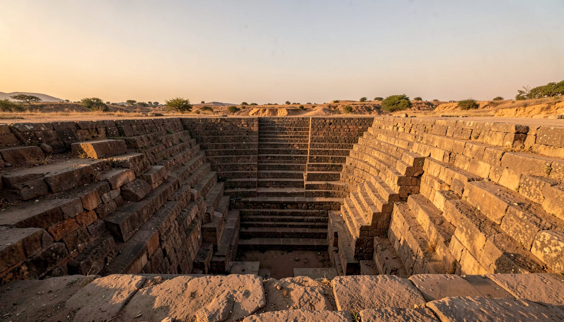
Unlike a simple circular well, a stepwell allowed people to descend gradually as the water level changed. Broad flights of stairs, landings, retaining walls and shaded galleries made the structure accessible to women collecting water, travellers, animals and religious visitors. The descent also reduced the physical strain of drawing water from depth, particularly during the dry season.
Stone choice and construction methods changed from place to place. Local sandstone, limestone and other durable materials were shaped into steps, pillars, niches and retaining walls. In coastal districts, salt-laden air and groundwater could accelerate decay, while inland sites faced windblown dust, vegetation and the pressure of expanding roads and buildings.
Rock-cut wells and urban memory
Junagadh contains some of the peninsula’s most distinctive water structures. Within the historic Uparkot fort, the Adi Kadi Vav and Navghan Kuvo are cut into living rock rather than assembled as monumental masonry galleries. Their narrow, dramatic descents show a different response to geology: instead of building outward with elaborately carved columns, workers penetrated the plateau to reach water below.
The Adi Kadi Vav is associated with a long flight of steps carved into the rock, while Navghan Kuvo is reached through a deep passage. Their restrained surfaces can seem less decorative than celebrated Gujarati vavs, yet the engineering is just as revealing. The work required planning, labour and a detailed understanding of the plateau’s structure, with access designed for a population that depended on water within a fortified settlement.
Other wells across Saurashtra are more difficult to identify. A small vav may be absorbed into a village courtyard, fenced off near a shrine or obscured by later concrete repairs. Oral histories, cadastral records, old maps and conversations with residents can be as important as architectural inspection. A name such as vavdi, juna kuva or matano vav may preserve a clue even when the original structure has been altered.
The social life of a vav
A stepwell was rarely an isolated utility. Its shaded platforms offered a place to rest, meet, exchange news and pause during a journey. In many parts of India, women’s daily water work created strong social connections around wells and tanks, while merchants, pilgrims and local rulers contributed to their construction or maintenance.
Carved images and small shrines sometimes connect a water structure with Hindu devotional traditions, goddess worship or local protective deities. Yet the meaning of a vav cannot be reduced to ornament. Its most important heritage may lie in repeated acts: cleaning the steps, repairing a parapet, drawing water, lighting a lamp or teaching a child the story of the site.
This social dimension is relevant in Australian cities where public water infrastructure is often hidden underground or enclosed behind treatment facilities. People in Melbourne may check seasonal water rules before washing cars or watering gardens, while households in Brisbane and Perth commonly think about tank storage, drought and sudden heavy rain. A stepwell makes those invisible systems spatial and communal.
Why many sites have been overlooked
Modern water supply has changed the role of traditional wells. Bore pumps, pipelines, overhead tanks and municipal taps provide water more conveniently in many settlements, leaving old stepwells without a daily function. Once people stop descending, vegetation takes root in the stairways, rubbish accumulates and repairs become harder to justify.
Urban growth creates a second pressure. A vav beside a widening road can be treated as an obstruction, while a well inside a redeveloped property may disappear beneath paving or construction. Tourism also produces uneven attention: a grand, well-photographed monument receives visitors and funding, while a modest village structure with little decoration remains absent from official narratives.
Heritage protection is further complicated by ownership and jurisdiction. A site may fall under a temple trust, a local municipality, a private landholder or a state department. In Australia, comparable questions arise through state heritage registers, local planning schemes and instruments such as Victoria’s Heritage Act 2017. Listing can provide recognition and controls, but it does not automatically guarantee maintenance, interpretation or community use.
Recording what remains
Good documentation begins with more than a dramatic photograph. Researchers can record a site’s location, orientation, dimensions, construction materials, water depth, access condition and relationship to nearby roads, temples or houses. Drone imagery can reveal buried alignments and landscape connections, while measured drawings show how steps, landings and retaining walls fit together.
Photography should include details that help future researchers understand change: patched masonry, blocked entrances, inscriptions, drainage channels, tool marks and traces of plaster. A clear record of present condition is particularly valuable when a structure is vulnerable to monsoon flooding, road expansion or redevelopment. Comparing images over time can distinguish natural weathering from deliberate alteration.
Fieldwork in Maharashtra offers useful methods for this kind of investigation, from combining architectural sketches with interviews to mapping sites that are absent from popular heritage lists. The Maharashtra campaign reflects an approach that treats documentation as a public record rather than a hunt for picturesque ruins. Similar work in Kathiawar could connect local knowledge with systematic surveys across districts.
From local knowledge to shared heritage
Residents are often the first people to recognise a forgotten well. An older shopkeeper may know when its water last flowed; a farmer may remember a path that once led to the steps; a priest may hold a story about a benefactor or festival. Such accounts should be recorded carefully, compared with physical evidence and credited respectfully rather than treated as decorative folklore.
Digital archives can help connect scattered information, especially when a site has no signboard or formal listing. Location data, historic photographs, sketches and recorded interviews allow researchers to compare structures across the peninsula. People who have found an undocumented vav or baoli can use the contact page to share information for future heritage research.
The Australian audience has its own reason to care about these places. Australia’s heritage laws, including the Aboriginal and Torres Strait Islander Heritage Protection Act 1984, recognise that cultural landscapes carry knowledge that cannot be separated from place. Stepwells likewise belong to a wider landscape of routes, settlements, customs and water practices, rather than existing as isolated stone objects.
A neglected vav does not become irrelevant when its water is no longer drawn. Its steps still describe past climate adaptation, labour, belief and civic organisation. Across Kathiawar, careful documentation can preserve those layered meanings before repair, redevelopment or neglect removes the evidence.
Get in Touch
Have information about a stepwell that is not yet on our map? We would be glad to document it and give you full credit. Whether it is a Barav, Kund, Vihir, or any other form of stepwell, every contribution helps preserve India's water heritage.
Call or message us with details about the location, and we will follow up.
#9372496819
Send a Message
What People Say
"The Maharashtra Stepwells campaign has brought attention to structures that were nearly forgotten. The architectural documentation and drone photography are invaluable resources for researchers and students alike."
"Collaborating with the Indian Stepwells team gave our architecture students hands-on exposure to traditional water-harvesting structures. The presentations were insightful and inspiring."
"I shared details of a stepwell near my village that was not on any map. The team visited, documented it beautifully, and credited me. It felt wonderful to contribute."